File:Deutsch-Niederländischer Sprachraum (nach Werner König).png
Jump to navigation
Jump to search
Size of this preview: 760 × 600 pixels. Other resolutions: 304 × 240 pixels | 608 × 480 pixels | 973 × 768 pixels | 1,280 × 1,010 pixels | 2,123 × 1,676 pixels.
Original file (2,123 × 1,676 pixels, file size: 2.01 MB, MIME type: image/png)
Captions
Captions
Add a one-line explanation of what this file represents
Summary
[edit].png&action=edit§ion=1)
| Description |
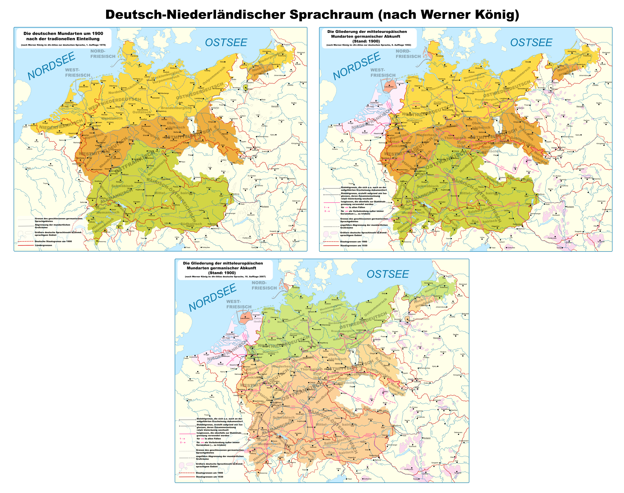
Deutsch: Beschreibung = Darstellung des deutsch-niederländischen Sprachraums, wie er vom Germanisten Werner König definiert und im dtv-Atlas zur deutschen Sprache oder im dtv-Atlas Deutsche Sprache veröffentlicht wurde. Karte 1 entstammt der 1. Auflage (1978), Karte 2 der 9. Auflage (1992) und Karte 3 der 16. Auflage (2007). |
| Date | |
| Source | Own work |
| Author | Hardcore-Mike |
| Permission (Reusing this file) |
cc-by-sa-3.0 |
Licensing
[edit].png&action=edit§ion=2)
I, the copyright holder of this work, hereby publish it under the following licenses:

|
Permission is granted to copy, distribute and/or modify this document under the terms of the GNU Free Documentation License, Version 1.2 or any later version published by the Free Software Foundation; with no Invariant Sections, no Front-Cover Texts, and no Back-Cover Texts. A copy of the license is included in the section entitled GNU Free Documentation License. |
This file is licensed under the Creative Commons Attribution 3.0 Unported license.
- You are free:
- to share – to copy, distribute and transmit the work
- to remix – to adapt the work
- Under the following conditions:
- attribution – You must give appropriate credit, provide a link to the license, and indicate if changes were made. You may do so in any reasonable manner, but not in any way that suggests the licensor endorses you or your use.
You may select the license of your choice.
File history
Click on a date/time to view the file as it appeared at that time.
.png&dir=prev)
.png&offset=20240602020644)
.png&offset=&limit=20)
.png&offset=&limit=50)
.png&offset=&limit=100)
.png&offset=&limit=250)
.png&offset=&limit=500)
| Date/Time | Thumbnail | Dimensions | User | Comment | |
|---|---|---|---|---|---|
| current | 16:15, 7 June 2024 | | 2,123 × 1,676 (2.01 MB) | MicBy67 (talk | contribs) | Sprachinsel Budweis farblich hervorgehoben, hatte ich vergessen. |
| 20:37, 6 June 2024 |  | 2,123 × 1,676 (2.01 MB) | MicBy67 (talk | contribs) | Sprachinsel Kulmsee ("Schwäbisch") wieder beschriftet. | |
| 20:28, 6 June 2024 |  | 2,123 × 1,676 (2.01 MB) | MicBy67 (talk | contribs) | Elbostfälisch in Karte von 1992 und 2007 nachgetragen. | |
| 19:49, 6 June 2024 |  | 2,123 × 1,676 (2 MB) | MicBy67 (talk | contribs) | Überflüssige Beschriftung ("Schwäbisch" bei Kulmsee herausgenommen. | |
| 19:36, 6 June 2024 |  | 2,123 × 1,676 (2 MB) | MicBy67 (talk | contribs) | Letzter Schliff, vor allem deutsche Nordgrenze von 1937 nachgetragen. | |
| 19:20, 6 June 2024 |  | 2,123 × 1,676 (2 MB) | MicBy67 (talk | contribs) | Fertigstellung. JETZT dürfte ich nichts mehr vergessen haben. | |
| 18:58, 6 June 2024 |  | 2,123 × 1,676 (1.91 MB) | MicBy67 (talk | contribs) | Einen Tacken größer und Legendenberichtigung bei den Karten 1992 und 2007. | |
| 17:55, 6 June 2024 |  | 2,040 × 1,580 (1.84 MB) | MicBy67 (talk | contribs) | Etwas größer und versehentlich in der Vorgängerkarte ausgeblendete Dialektbezeichnungen wieder eingefügt. | |
| 19:03, 4 June 2024 |  | 1,519 × 1,173 (1.05 MB) | MicBy67 (talk | contribs) | Fehlende Isoglosse eingezeichnet, alles etwas größer | |
| 02:06, 2 June 2024 |  | 1,123 × 794 (588 KB) | MicBy67 (talk | contribs) | Collage aus den bekannten drei König-Karten |
You cannot overwrite this file.
File usage on Commons
The following 7 pages use this file:
- User:Chumwa/OgreBot/Travel and communication maps/2016 August 1-10
- User:Chumwa/OgreBot/Travel and communication maps/2016 July 11-20
- User:Chumwa/OgreBot/Travel and communication maps/2016 May 21-31
- User:Chumwa/OgreBot/Travel and communication maps/2018 March 1-10
- User:Chumwa/OgreBot/Travel and communication maps/2024 June 1-10
- User:Magog the Ogre/Multilingual legend/2024 June 1-5
- User:Magog the Ogre/Multilingual legend/2024 June 6-10
File usage on other wikis
The following other wikis use this file:
- Usage on de.wikipedia.org
- Usage on de.wiktionary.org
- Usage on nds.wikipedia.org
Metadata
.png&oldid=881933622)
Categories:
- Linguistic maps of West Germanic languages
- Dialect maps of the Dutch language
- Linguistic maps of Low Franconian
- Linguistic maps of the Dutch language in Germany
- Linguistic maps of western Central Europe
- Linguistic maps of the Netherlands
- German-language maps showing history of Europe
- Locator maps of Germany in Europe
- German dialects
- Files by MicBy67