File:Deserted trench during World War I (4688509266).jpg
Jump to navigation
Jump to search

Size of this preview: 774 × 600 pixels. Other resolutions: 310 × 240 pixels | 619 × 480 pixels | 1,000 × 775 pixels.
Original file (1,000 × 775 pixels, file size: 111 KB, MIME type: image/jpeg)
Captions
Captions
Add a one-line explanation of what this file represents
Summary
[edit].jpg&action=edit§ion=1)
| Description |
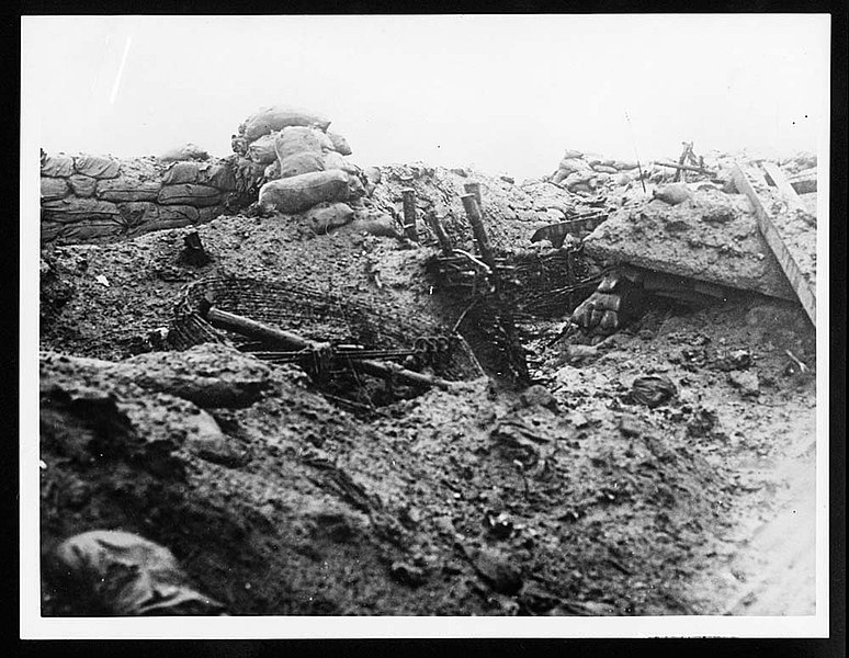
English: A deserted and muddy trench. In the background there is a fence which is constructed using large posts with interwoven branches running horizontally. This would have been used as a support to prevent collapse of the trench. Sandbags lie at the top of the trench, to absorb enemy bullets. There is a roll of barbed wire and various mud-covered items lying on the ground. World War I necessitated the development of a system of trench warfare. Soldiers employed a variety of weapons from Howitzers to bayonet guns to attack and defend in trench warfare. Tanks were not altogether suitable but photo-reconnaissance proved very helpful. Commanders could look at images taken from planes of the enemy's trench system and plan advances based on that. |
| Date | |
| Source | https://www.flickr.com/photos/nlscotland/4688509266/ |
| Author | National Library of Scotland |
| Permission (Reusing this file) |
At the time of upload, the image license was automatically confirmed using the Flickr API. For more information see Flickr API detail. |
| Flickr sets |
|
| Flickr tags |
|
| Camera location | | View this and other nearby images on: OpenStreetMap |
|---|
.jpg¶ms=046.710670_N_0001.718189_E_globe:Earth_type:camera__&language=en)
Licensing
[edit].jpg&action=edit§ion=2)
This image was taken from Flickr's The Commons. The uploading organization may have various reasons for determining that no known copyright restrictions exist, such as:
More information can be found at https://flickr.com/commons/usage/. Please add additional copyright tags to this image if more specific information about copyright status can be determined. See Commons:Licensing for more information. |
| This image was originally posted to Flickr by National Library of Scotland at https://flickr.com/photos/14456531@N07/4688509266. It was reviewed on 16 November 2016 by FlickreviewR and was confirmed to be licensed under the terms of the No known copyright restrictions. |
File history
Click on a date/time to view the file as it appeared at that time.
| Date/Time | Thumbnail | Dimensions | User | Comment | |
|---|---|---|---|---|---|
| current | 11:59, 8 January 2022 | | 1,000 × 775 (111 KB) | Ich (talk | contribs) | https://deriv.nls.uk/dcn30/35.30.jpg |
| 12:13, 16 November 2016 |  | 600 × 465 (50 KB) | Fæ (talk | contribs) | National Library of Scotland, Set 72157624150609895, ID 4688509266, Original title Deserted trench during World War I |
You cannot overwrite this file.
File usage on Commons
There are no pages that use this file.
.jpg&oldid=899138946)