File:Descripción costa de Veracruz. 1707.jpg
Jump to navigation
Jump to search

Size of this preview: 800 × 570 pixels. Other resolutions: 320 × 228 pixels | 640 × 456 pixels | 1,024 × 729 pixels | 1,280 × 912 pixels | 2,495 × 1,777 pixels.
Original file (2,495 × 1,777 pixels, file size: 739 KB, MIME type: image/jpeg)
Captions
Captions
Add a one-line explanation of what this file represents
Summary
[edit]
| Description |
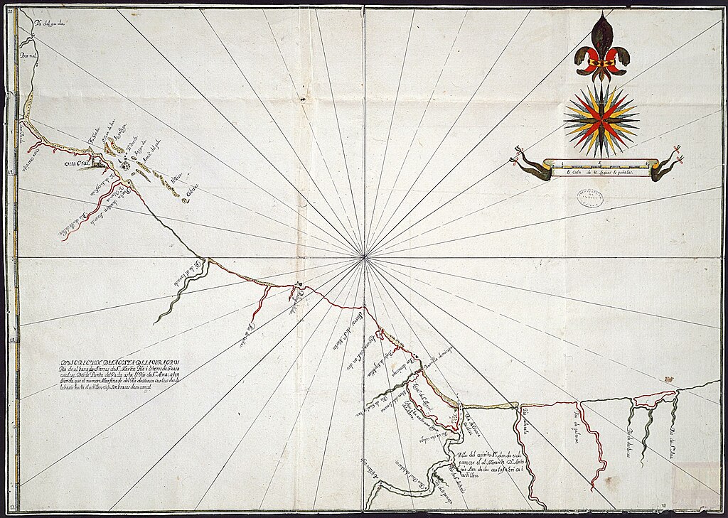
Español: Presenta la costa occidental del Seno Mexicano desde Punta Delgada al río de Santa Ana. Indica la ciudad de Veracruz de forma convencional e islas costeras frente a la ciudad. Señala el lugar del astillero viejo y el lugar donde se propone la fabricación del nuevo.
Costa sombreada en rojo y verde. Hidrografía. Toponimia costera. Arenales. Sondeo en brazas. Por Real Cédula de 8 de febrero de 1705 se mandó al virrey Francisco Fernández de la Cueva, duque de Alburquerque, que se hiciese un reconocimiento de la barra, río y montes de Coatzacoalcos e isla de Sacrificios para estudiar la conveniencia de construir un astillero. Tanto el primer como el segundo reconocimiento de la zona. Se mandaron dos expediciones: la primera compuesta por pilotos y carpinteros de la flota de Diego Fernández de Santillán; la segunda, a la que pertenecen los mapas, por el almirante Antonio de Landeche, gobernador de la Armada de Barlovento, que llevó consigo a Diego de Figueroa, capitán de la maestranza de dicha Armada, al piloto Bartolomé Agustín y a maestros carpinteros y calafate. |
| Date | |
| Source | ES.41091.AGI//MP-MEXICO,573 |
| Author | ©MCD. Archivos Estatales (España) |
Licensing
[edit]
This file is licensed under the Creative Commons Attribution-Share Alike 4.0 International license.
- You are free:
- to share – to copy, distribute and transmit the work
- to remix – to adapt the work
- Under the following conditions:
- attribution – You must give appropriate credit, provide a link to the license, and indicate if changes were made. You may do so in any reasonable manner, but not in any way that suggests the licensor endorses you or your use.
- share alike – If you remix, transform, or build upon the material, you must distribute your contributions under the same or compatible license as the original.

|
This media file is uncategorized.
Please help improve this media file by adding it to one or more categories, so it may be associated with related media files (how?), and so that it can be more easily found.
Please notify the uploader with {{subst:Please link images|File:Descripción costa de Veracruz. 1707.jpg}} ~~~~ |
File history
Click on a date/time to view the file as it appeared at that time.
| Date/Time | Thumbnail | Dimensions | User | Comment | |
|---|---|---|---|---|---|
| current | 08:40, 3 April 2023 | | 2,495 × 1,777 (739 KB) | Fotosub (talk | contribs) | Uploaded a work by ©MCD. Archivos Estatales (España) from ES.41091.AGI//MP-MEXICO,573 with UploadWizard |
You cannot overwrite this file.
File usage on Commons
There are no pages that use this file.
File usage on other wikis
The following other wikis use this file:
- Usage on es.wikipedia.org