File:Descriçom do terreo de Pena Froufe (1649, cópia de 1849).jpg
Jump to navigation
Jump to search

Size of this preview: 780 × 600 pixels. Other resolutions: 312 × 240 pixels | 625 × 480 pixels | 999 × 768 pixels | 1,223 × 940 pixels.
Original file (1,223 × 940 pixels, file size: 1.37 MB, MIME type: image/jpeg)
Captions
Captions
Add a one-line explanation of what this file represents
Summary
[edit].jpg&action=edit§ion=1)
| Description |
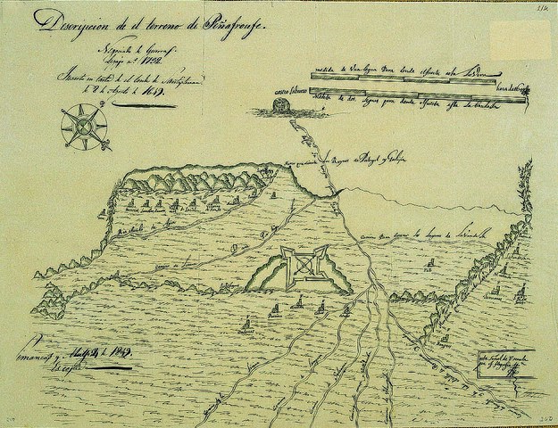
Galego: Mapa dos arredores do forte do Teso ou de Penafroufe, titulado Descripción del terreno de Peñafroufe e copiado en 1849 dun orixinal do ano 1649. Notas manuscritas do plano orixinal: Castro Laborero; Medida de una legua para dende el fuerte asta lovera; Hera de 1649; Medida de dos leguas para dende el fuerte asta Labandela; Camino de Castro Laboreyro para (…); Marco que divide los Reynos de Portugal y Galiçia; Parte del Rio Minho; Camino para socorrer los lugares de Lavandela; Padrende; Labandela; Pojo; M. redondo; Taurianes; S. Pedro das torres; Montaña que cubre asta Lavandelas; Bangeses; Esta señal de F señala que es feligresia; Camino de bangeses y de todo el Valle de Peñafroufe y Leirado; Camino de Vilmasida; Camino de orençe y Villanueba; Camino de Selanova; Camino de Lompaça; Camino de la Limia; (…); Calvos; Corvella; Pereira; Cadones; Las hoynas; Camino de Lovera para Portugal; Riachuelo de Agua; Geas; Torneras; Lamolar; Savares; Valdemir; Lacal; Villarino de San Jes; Senderio; Parada; La plaza. Pódese salientar o Marco que divide los Reynos de Portugal y Galiçia, que proba a realidade política do reino galego.[1] |
| Date | 1649; 1849 |
| Source | http://culturagalega.gal/imaxes/docs/planosgaliciaSXVI_XVII.zip |
| Author | José Aparici y García (copista) |
| Other versions |
 |
Licensing
[edit].jpg&action=edit§ion=2)
|
This is a faithful photographic reproduction of a two-dimensional, public domain work of art. The work of art itself is in the public domain for the following reason:
The official position taken by the Wikimedia Foundation is that "faithful reproductions of two-dimensional public domain works of art are public domain".
This photographic reproduction is therefore also considered to be in the public domain in the United States. In other jurisdictions, re-use of this content may be restricted; see Reuse of PD-Art photographs for details. | ||||
File history
Click on a date/time to view the file as it appeared at that time.
| Date/Time | Thumbnail | Dimensions | User | Comment | |
|---|---|---|---|---|---|
| current | 19:20, 23 July 2022 | | 1,223 × 940 (1.37 MB) | One2 (talk | contribs) | Uploaded a work by José Aparici y García (copista) from http://culturagalega.gal/imaxes/docs/planosgaliciaSXVI_XVII.zip with UploadWizard |
You cannot overwrite this file.
File usage on Commons
The following page uses this file:
File usage on other wikis
The following other wikis use this file:
- Usage on gl.wikipedia.org
Metadata
.jpg&oldid=738757472)
Categories:
- 1649 in Galicia (Spain)
- Penafroufe fort
- Bangueses, Verea
- Castro Laboreiro
- Old maps of the province of Ourense
- Cadós, Bande
- Calvos, Bande
- Corvelle, Bande
- Monte Redondo, Padrenda
- Padrenda, Padrenda
- San Pedro da Torre, Padrenda
- San Xes de Vilariño, Lobeira
- Kingdom of Galicia (Iberian Peninsula)
- 1849 in Galicia (Spain)