File:Derrota que hicieron los dos navios de SM. Castilla y Europa devajo del mando del Gefe de Esquadra, el Señor Dn. Franco. de Orosco, desde la Ensenada de Maldonado asta el puerto de la Consepción de LOC 90682598.jpg
Jump to navigation
Jump to search

Size of this preview: 727 × 600 pixels. Other resolutions: 291 × 240 pixels | 582 × 480 pixels | 931 × 768 pixels | 1,241 × 1,024 pixels | 2,482 × 2,048 pixels | 7,596 × 6,269 pixels.
Original file (7,596 × 6,269 pixels, file size: 5.48 MB, MIME type: image/jpeg)
Captions
Captions
Add a one-line explanation of what this file represents
Summary
[edit]| Description |
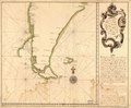
English: Shows the route followed by the Spanish warships Castilla and Europa under the command of Don Francisco de Orosco in their voyage from Rio de la Plata to Concepción de Chile via Cape Horn in 1748. Depths shown by soundings. Watermarks: IV; and, Strasburg fleur-de-lis. Black, brown, and red inks and watercolor. Mounted on cloth backing. LC Luso-Hispanic World, 103 Available also through the Library of Congress Web site as a raster image. Annotated in black ink: N. 4 [indecipherable]. Maggs number annotated in pencil in lower right corner: 27. Printed label describing the map mounted on verso. Includes note. Vault |
||
| Title | Derrota que hicieron los dos navios de SM. Castilla y Europa devajo del mando del Gefe de Esquadra, el Señor Dn. Franco. de Orosco, desde la Ensenada de Maldonado asta el puerto de la Consepción de Chile el año de 1748 | ||
| Shelf ID | G5351.S1 1760 .C5 | ||
| Date | |||
| Source | https://www.loc.gov/item/90682598/ | ||
| Author | Cierto, Andres; Cumplido, Francisco; Aranda, Juachin De.; Real Escuela De Navegación (Cádiz, Spain) | ||
| Permission (Reusing this file) |
|
||
| Other versions |
|
||
| Location | Atlantic Coast · Argentina · Chile · Pacific Coast | ||
| Part of | American Memory · Catalog · Geography And Map Division · Cultural Landscapes | ||
| Subject | Maps, Manuscript · Maps · Early Works To 1800 · Atlantic Coast (Argentina) · Chile · Atlantic Coast · Argentina · Pacific Coast (Chile) · Pacific Coast · History |

Licensing
[edit]
|
This is a faithful photographic reproduction of a two-dimensional, public domain work of art. The work of art itself is in the public domain for the following reason:
The official position taken by the Wikimedia Foundation is that "faithful reproductions of two-dimensional public domain works of art are public domain".
This photographic reproduction is therefore also considered to be in the public domain in the United States. In other jurisdictions, re-use of this content may be restricted; see Reuse of PD-Art photographs for details. | ||||
File history
Click on a date/time to view the file as it appeared at that time.
| Date/Time | Thumbnail | Dimensions | User | Comment | |
|---|---|---|---|---|---|
| current | 15:22, 17 May 2018 | | 7,596 × 6,269 (5.48 MB) | Fæ (talk | contribs) | LOC Maps https://www.loc.gov/item/90682598/ #10260 |
You cannot overwrite this file.
File usage on Commons
The following page uses this file: