File:Derbent heritage map.png
Original file (895 × 745 pixels, file size: 642 KB, MIME type: image/png)
Captions
Captions
Summary
[edit]
| Description |
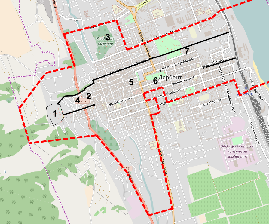
Русский: Красная линия - територия в. н. ЮНЕСКО
Черная линия - дербентская стена 1 - крепость Нарын-кала 2 - Джума-мечеть 3 - кладбище Кырхляр 4 - старинная восточная баня 5 - Церковь Святого Всеспасителя (армянская) 6 - синагога Келе-Нумаз 7 - дербентский маякEnglish: Red line - UNESCO heritage area
Black line - the city fortress 1 - Fortress Naryn-Kala 2 - Juma Mosque 3 - Kyrhlar graveyard 4 - old eastern bath 5 - Armenian Saint Sargis Church 6 - Kele-Numaz Synagogue 7 - Derbent LighthouseČeština: Červená linka - část města pod ochranou UNESCO
Černá linka - městské hradby 1 - pevnost Naryn-kala 2 - mešita Džuma 3 - hřbitov Kyrchljar 4 - stará východní lázeň 5 - arménský chrám Svatého Spasitele 6 - synagoga Kele-Numaz 7 - maják |
| Date | |
| Source | © Contributors OpenStreetMap, edited by Trasprd |
| Author | Trasprd |
| Camera location | | View this and other nearby images on: OpenStreetMap |
|---|
Licensing
[edit]
- You are free:
- to share – to copy, distribute and transmit the work
- to remix – to adapt the work
- Under the following conditions:
- attribution – You must give appropriate credit, provide a link to the license, and indicate if changes were made. You may do so in any reasonable manner, but not in any way that suggests the licensor endorses you or your use.
- share alike – If you remix, transform, or build upon the material, you must distribute your contributions under the same or compatible license as the original.
File history
Click on a date/time to view the file as it appeared at that time.
| Date/Time | Thumbnail | Dimensions | User | Comment | |
|---|---|---|---|---|---|
| current | 08:12, 6 November 2016 | | 895 × 745 (642 KB) | Trasprd (talk | contribs) | User created page with UploadWizard |
You cannot overwrite this file.
File usage on Commons
There are no pages that use this file.
File usage on other wikis
The following other wikis use this file:
- Usage on cs.wikipedia.org