File:Demolishing Cyrville Station.jpg
![File:Demolishing Cyrville Station.jpg](https://upload.wikimedia.org/wikipedia/commons/thumb/8/80/Demolishing_Cyrville_Station.jpg/800px-Demolishing_Cyrville_Station.jpg?20150830035803)
Original file (3,264 × 2,448 pixels, file size: 3.14 MB, MIME type: image/jpeg)
Captions
Captions
Summary
[edit]DescriptionDemolishing Cyrville Station.jpg |
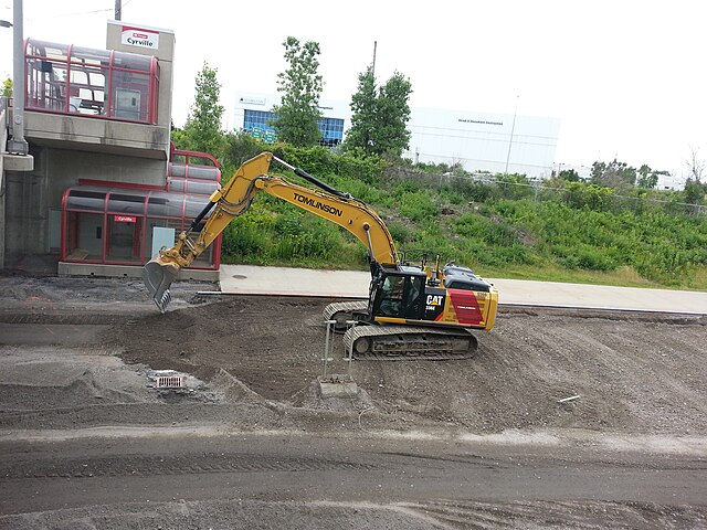
English: Demolition work at the Cyrville Transitway station in Ottawa. To make way for light rail lines, OC-Transpo infrastructure is being demolished. Here the paved road surface is being removed. Only part of the concrete platform, which ran the full length of the station remains. The portion under the overpass has been removed. Viewed from the Western side of the Cyrville road overpass looking South. Français : Travaux de démolition de la station Cyrville du Transitway, dans l`est d'Ottawa. Afin de permettre l'installation d'un nouveau système de transport par rail, une partie des installations du Transitway (voie rapide pour autobus) est démolie. On les travaux d'enlèvement de l'asphalte sont en cours. Les cables électriques souterrains ont déjà été retirés de la portion centrale. |
Date | |
Source | Own work |
Author | Denis Vermeirre |
Camera location | 45° 25′ 21.12″ N, 75° 37′ 23.83″ W ![]() | View this and other nearby images on: OpenStreetMap | ![]() |
---|
Licensing
[edit]![w:en:Creative Commons](https://upload.wikimedia.org/wikipedia/commons/thumb/7/79/CC_some_rights_reserved.svg/90px-CC_some_rights_reserved.svg.png)
![attribution](https://upload.wikimedia.org/wikipedia/commons/thumb/1/11/Cc-by_new_white.svg/24px-Cc-by_new_white.svg.png)
![share alike](https://upload.wikimedia.org/wikipedia/commons/thumb/d/df/Cc-sa_white.svg/24px-Cc-sa_white.svg.png)
- You are free:
- to share – to copy, distribute and transmit the work
- to remix – to adapt the work
- Under the following conditions:
- attribution – You must give appropriate credit, provide a link to the license, and indicate if changes were made. You may do so in any reasonable manner, but not in any way that suggests the licensor endorses you or your use.
- share alike – If you remix, transform, or build upon the material, you must distribute your contributions under the same or compatible license as the original.
File history
Click on a date/time to view the file as it appeared at that time.
Date/Time | Thumbnail | Dimensions | User | Comment | |
---|---|---|---|---|---|
current | 03:58, 30 August 2015 | ![]() | 3,264 × 2,448 (3.14 MB) | Dvermeirre (talk | contribs) | User created page with UploadWizard |
You cannot overwrite this file.
File usage on Commons
The following page uses this file:
Metadata
This file contains additional information such as Exif metadata which may have been added by the digital camera, scanner, or software program used to create or digitize it. If the file has been modified from its original state, some details such as the timestamp may not fully reflect those of the original file. The timestamp is only as accurate as the clock in the camera, and it may be completely wrong.
Camera manufacturer | SAMSUNG |
---|---|
Camera model | SGH-T999V |
Exposure time | 1/373 sec (0.0026809651474531) |
F-number | f/2.6 |
ISO speed rating | 80 |
Date and time of data generation | 12:47, 17 July 2015 |
Lens focal length | 3.7 mm |
User comments | ŒÃuxV4xV4xV4xV4`bAèÿÿxüN„ýýCALZDFE02Cur.ZDFI02CML018001001509FD0901090109010D010D010D090Dï'ë&TUNAÐŒ]]ôk©T–öUÿÿ¶sÓÿÿúJ“áÿÿ'
\Rÿÿ} FLFLSVN#
®ÐŒ\]]\ a Z
?…|þš 8JKJK #ò+šv¢ÂB…Œ]xó‹«ôk©T–öUÿÿ¶sÓÿÿúJ“áÿÿ' \Rÿÿ} JKJK™ ‘€ ’™ ’™ ’™ ’™ ’™ ’™ ’™ ’™ ’™ ’™ ’™ ’™ ‘pp`1"’™ !"!" ’™ ’™ ’™ ’™ ’™ ’™ ’™ ‘@"P3€ !""!" !"!"’™ ‘’™ ’™ ’™ ’™ `P3P3p!""!""!"""""’™ ’™ ’™ ‘‘P3P3Bw2w2w"w"w"""@" € ‘‘‘ppbR2w2w2w!" !"1"1" ‘‘€ ‘pBw2wRR2w2w2w2w2w2w2w‘‘‘‘`2w2w2wR2w2w2w2w2w2w2w‘‘‘P3`P3P3Q3A"@"`Q3A"A"A"Bw‘`P3‘P3`P3P3Q3‘p`````P3P3P3P3P3P3P3Q3Q3‘P3P3P3P3``P3P3P3`P3P3`P3P3P3P3P3P3P3P3`‘‘P3P3P3P3P3P3P3`P3P3P3P3```P3P3P3P3P3P3P3P3P3P3P3P3P3``‘‘‘P3P3P3P3P3P3P3P3P3P3```‘``P3P3P3P3P3P3P3P3P3````JKJKŽûðÿÖ (Ä¡xßþÿÚ¾?়ÅþÿU¤Ñ󪫂󓫂󓫂󓫬,o ýAFAF^º$Ó]î¼öî&Í6Ô,íÔED¶{ ¶Ò‚˜ôO˜@'ººØ Ø¡öB5ö&§ÆÀ ¹ôZ' ÊU*“sù#- ù-<ò"€ò-œëÐë*¶íù$Ðù.¥±ùùùùùùùùAFAFøZDùAFAFäÞ°ô€ X ¤xR¼)Þ)Þss\&ºÆ³6nLLNPRTΊFß›WðÞ¼šý&24ƒ yƒ y |
Latitude | 45° 25′ 21.12″ N |
Longitude | 75° 37′ 23.83″ W |
Altitude | 0 meters above sea level |
Width | 3,264 px |
Height | 2,448 px |
Orientation | Normal |
Horizontal resolution | 72 dpi |
Vertical resolution | 72 dpi |
Software used | T999VVLUFNH2 |
File change date and time | 12:47, 17 July 2015 |
Y and C positioning | Centered |
Exposure Program | Aperture priority |
Exif version | 2.2 |
Date and time of digitizing | 12:47, 17 July 2015 |
Meaning of each component |
|
APEX shutter speed | 8.546875 |
APEX aperture | 2.76 |
APEX brightness | 6.76171875 |
APEX exposure bias | 0 |
Maximum land aperture | 2.76 APEX (f/2.6) |
Metering mode | Center weighted average |
Light source | Unknown |
Flash | Flash did not fire |
Supported Flashpix version | 1 |
Color space | sRGB |
Sensing method | One-chip color area sensor |
Scene type | 49 |
Exposure mode | Auto exposure |
White balance | Auto white balance |
Scene capture type | Standard |
Unique image ID | ZDFI02 |
GPS time (atomic clock) | 16:46 |
GPS date | 17 July 2015 |
GPS tag version | 0.0.2.2 |