File:Demak Sultanate conquests and expeditions (id).svg
Jump to navigation
Jump to search

Size of this PNG preview of this SVG file: 800 × 328 pixels. Other resolutions: 320 × 131 pixels | 640 × 262 pixels | 1,024 × 420 pixels | 1,280 × 525 pixels | 2,560 × 1,049 pixels | 1,327 × 544 pixels.
Original file (SVG file, nominally 1,327 × 544 pixels, file size: 307 KB)
Captions
Captions
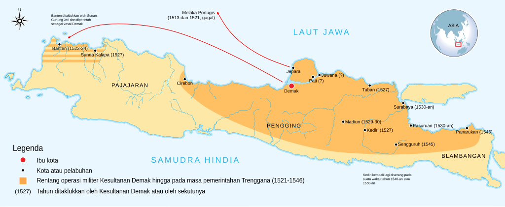
Range of Demak Sultanate's military operation
Summary
[edit].svg&action=edit§ion=1)
| Description |
Bahasa Indonesia: Rentang operasi militer yang dilakukan Kesultanan Demak hingga masa pemerintahan Trenggana yang berkisar antara 1518-1546 |
| Date | |
| Source |
Information and visualization is based on:
This file was derived from: |
| Author | This file: Adhiansyah Ancha. Derived maps: Gunawan Kartapranata |
| Other versions |
 |
| SVG development |
Licensing
[edit].svg&action=edit§ion=2)
This file is licensed under the Creative Commons Attribution-Share Alike 3.0 Unported license.
- You are free:
- to share – to copy, distribute and transmit the work
- to remix – to adapt the work
- Under the following conditions:
- attribution – You must give appropriate credit, provide a link to the license, and indicate if changes were made. You may do so in any reasonable manner, but not in any way that suggests the licensor endorses you or your use.
- share alike – If you remix, transform, or build upon the material, you must distribute your contributions under the same or compatible license as the original.
File history
Click on a date/time to view the file as it appeared at that time.
| Date/Time | Thumbnail | Dimensions | User | Comment | |
|---|---|---|---|---|---|
| current | 06:57, 26 June 2021 | 1,327 × 544 (307 KB) | AnsyahF (talk | contribs) | Some corrections | |
| 02:16, 25 June 2021 | 1,327 × 544 (305 KB) | AnsyahF (talk | contribs) | Recreate map and new improvements | ||
| 23:35, 14 June 2021 | 1,478 × 544 (320 KB) | AnsyahF (talk | contribs) | Tried to fix fonts position | ||
| 13:39, 14 June 2021 | 1,478 × 544 (325 KB) | AnsyahF (talk | contribs) | Fonts fixed and added some information | ||
| 13:01, 14 June 2021 | 1,478 × 544 (322 KB) | AnsyahF (talk | contribs) | Uploaded a work by This file: Adhiansyah Ancha. Derived map: Gunawan Kartapranata from # Information and visualization based on: ## {{Cite book|last=Ricklefs|first=Merle Calvin|date=1993|url=https://books.google.co.id/books?id=gkldDwAAQBAJ&newbks=1&newbks_redir=0&dq=demak+conquest+madiun&hl=id&source=gbs_navlinks_s|title=A History of Modern Indonesia since c-1300|publisher=Macmillan International Higher Education|isbn=978-1-349-22700-6|pages=37|language=en|u... |
You cannot overwrite this file.
File usage on Commons
The following 3 pages use this file:
.svg&redirect=no)
File usage on other wikis
The following other wikis use this file:
- Usage on en.wikipedia.org
- Usage on id.wikipedia.org
- Usage on min.wikipedia.org
- Usage on su.wikipedia.org
.svg&oldid=715425151)