File:Delta pylon near Nyalka HU 2016.jpg
From Wikimedia Commons, the free media repository
Jump to navigation
Jump to search
Size of this preview: 450 × 600 pixels. Other resolutions: 180 × 240 pixels | 360 × 480 pixels | 576 × 768 pixels | 768 × 1,024 pixels | 1,536 × 2,048 pixels | 2,838 × 3,784 pixels.
Original file (2,838 × 3,784 pixels, file size: 5.66 MB, MIME type: image/jpeg)
File information
Structured data
Captions
DescriptionDelta pylon near Nyalka HU 2016.jpg |
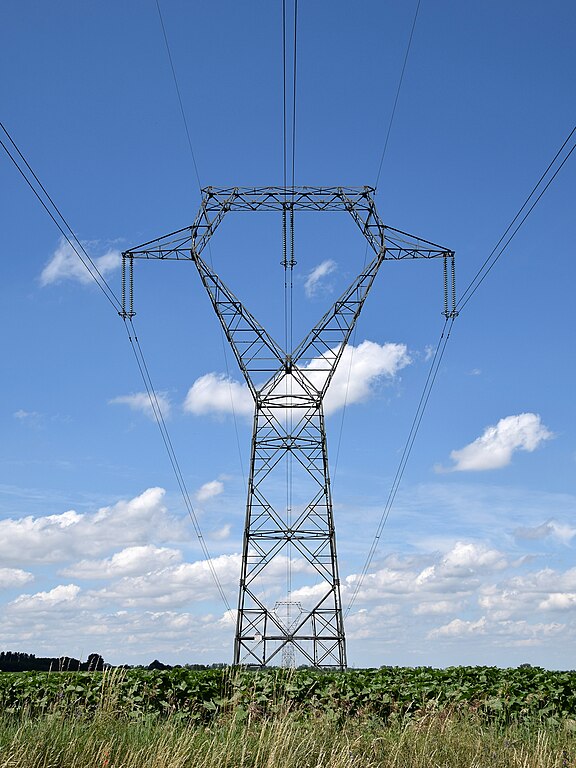
English: Delta pylon (400 kV) alongside street Rakoczi Ut, near Nyalka, Hungary.
These pylons have a V-shaped top carrying the traverses. Delta pylons (nearly) always have one phase-wire running through the enclosed hole on top of the pylon. Note the rather long strings with 26 insulator discs.
Nederlands: Deltamast (400 kV) langs de landweg Rakoczi Ut, nabij Nyalka, Hongarije.
Een deltamast heeft één mast die in tweeën splitst. Daarboven bevinden zich een aantal traversen, die in het mastlichaam een omsloten opening vormen waar een fasedraad doorheen loopt. De fasedraden hangen aan een keten van 26 isolatorschijven. |
||
Date | |||
Source | Delta Pylon | ||
Author | Luc.T | ||
Permission (Reusing this file) |
This file is licensed under the Creative Commons Attribution 2.0 Generic license. Attribution: Luc.T
|
Camera location | 47° 32′ 46.77″ N, 17° 49′ 01.76″ E | View this and other nearby images on: OpenStreetMap | 47.546325; 17.817156 |
---|
File history
Click on a date/time to view the file as it appeared at that time.
Date/Time | Thumbnail | Dimensions | User | Comment | |
---|---|---|---|---|---|
current | 16:22, 1 October 2017 | 2,838 × 3,784 (5.66 MB) | Te750iv (talk | contribs) | {{Information |Description={{en|1=Delta pylon alongside street Rakoczi Ut, near Nyalka, Hungary. These pylons have a V-shaped top carrying the traverses. Delta pylons (nearly) always have one phase-wire running through the enclosed hole on top of the p... |
You cannot overwrite this file.
File usage on Commons
There are no pages that use this file.
File usage on other wikis
The following other wikis use this file:
- Usage on fi.wikipedia.org
Metadata
This file contains additional information such as Exif metadata which may have been added by the digital camera, scanner, or software program used to create or digitize it. If the file has been modified from its original state, some details such as the timestamp may not fully reflect those of the original file. The timestamp is only as accurate as the clock in the camera, and it may be completely wrong.
Camera manufacturer | NIKON CORPORATION |
---|---|
Camera model | NIKON D3300 |
Exposure time | 1/500 sec (0.002) |
F-number | f/10 |
ISO speed rating | 200 |
Date and time of data generation | 13:27, 21 June 2016 |
Lens focal length | 26 mm |
Latitude | 47° 32′ 46.77″ N |
Longitude | 17° 49′ 1.76″ E |
Altitude | 166.93 meters above sea level |
City shown | Nyalka |
Orientation | Normal |
Horizontal resolution | 300 dpi |
Vertical resolution | 300 dpi |
Software used | Ver.1.01 |
File change date and time | 13:27, 21 June 2016 |
Y and C positioning | Centered |
Exposure Program | Aperture priority |
Exif version | 2.3 |
Date and time of digitizing | 13:27, 21 June 2016 |
Meaning of each component |
|
Image compression mode | 4 |
APEX exposure bias | 0 |
Maximum land aperture | 3.9 APEX (f/3.86) |
Metering mode | Pattern |
Light source | Fine weather |
Flash | Flash did not fire |
DateTime subseconds | 10 |
DateTimeOriginal subseconds | 10 |
DateTimeDigitized subseconds | 10 |
Supported Flashpix version | 1 |
Color space | sRGB |
Sensing method | One-chip color area sensor |
File source | Digital still camera |
Scene type | A directly photographed image |
Custom image processing | Normal process |
Exposure mode | Auto exposure |
White balance | Manual white balance |
Digital zoom ratio | 1 |
Focal length in 35 mm film | 39 mm |
Scene capture type | Standard |
Scene control | None |
Contrast | Normal |
Saturation | Normal |
Sharpness | Hard |
Subject distance range | Unknown |
GPS time (atomic clock) | 11:27 |
Geodetic survey data used | WGS-84 |
GPS date | 21 June 2016 |
GPS tag version | 0.0.2.2 |
Keywords |
|
IIM version | 4 |
Sublocation of city shown | Kisstanya |
Province or state shown | Győr-Moson-Sopron |
Code for country shown | HUN |
Country shown | Hungary |