File:Dellach Sappl Matzelsdorf Openstreetmap.png
From Wikimedia Commons, the free media repository
Jump to navigation
Jump to search

Size of this preview: 462 × 600 pixels. Other resolutions: 185 × 240 pixels | 370 × 480 pixels | 744 × 966 pixels.
Original file (744 × 966 pixels, file size: 444 KB, MIME type: image/png)
File information
Structured data
Captions
Captions
Add a one-line explanation of what this file represents
Summary
[edit]| DescriptionDellach Sappl Matzelsdorf Openstreetmap.png |
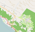
Deutsch: Diese (noch nicht ganz vollständige) Karte des offen Kartenerstellungsprojekts OpenStreetMap zeigt die Ortschaften Görtschach, Sappl, Matzelsdorf, Dellach, Starfach und den Millstätter See. Diese Karte entstammt dem offenen OpenStreetMap Projekt, erstellt von der Community. Diese Karte kann unvollständig sein oder Fehler enthalten. Verlasse dich in Navigationsfragen nicht alleine darauf. English: This map was created from OpenStreetMap project data, collected by the community. This map may be incomplete, and may contain errors. Don't rely solely on it for navigation. Español: Este mapa fue creado con los datos del proyecto OpenStreetMap, obtenidos por la comunidad. Este mapa puede estar incompleto, y puede contener errores. No se fíe solamente en él para las navegaciones. Français : Cette carte a été créée à partir des données du projet OpenStreetMap. Cette carte est peut-être incomplète et peut contenir des erreurs. Ne vous fiez pas uniquement à elle pour vos déplacements. Italiano: Questa mappa è stata creata con dati raccolti dal progetto OpenStreetMap. La mappa potrebbe essere incompleta e contenere errori. Non affidarsi esclusivamente ad essa per la navigazione. |
| Date | see file history |
| Source | www.openstreetmap.org |
| Author | OpenStreetMap contributors |
| Permission (Reusing this file) |
All OpenStreetMap data and maps are Creative Commons "CC-BY-SA 2.0" licensed This file is licensed under the Creative Commons Attribution-Share Alike 2.0 Generic license.
|
| Camera location | 46° 47′ 31.92″ N, 13° 37′ 16.56″ E | View this and other nearby images on: OpenStreetMap |
|---|
File history
Click on a date/time to view the file as it appeared at that time.
| Date/Time | Thumbnail | Dimensions | User | Comment | |
|---|---|---|---|---|---|
| current | 21:44, 2 November 2018 |  | 744 × 966 (444 KB) | Joadl (talk | contribs) | Etwas breiter, damit Starfach mit dabei ist. |
| 22:13, 14 September 2018 |  | 683 × 815 (369 KB) | Joadl (talk | contribs) | Aktueller Screen von Openstreetmap. | |
| 20:10, 5 May 2012 |  | 755 × 692 (239 KB) | Joadl (talk | contribs) | openstreetmap Release 5 May 2012 | |
| 22:14, 9 February 2011 |  | 414 × 453 (49 KB) | Joadl (talk | contribs) | {{Information |Description= {{de|Diese (noch nicht ganz vollständige) Karte des offen Kartenerstellungsprojekts OpenStreetMap zeigt die Ortschaften Obermillstatt, Lammersdorf, Grantsch, Görtschach, Sappl, Dellach, Pesenthein und den Millstätter See. -- |
You cannot overwrite this file.
File usage on Commons
The following page uses this file:
- File:Sappl Openstreetmap 110209.png (file redirect)
File usage on other wikis
The following other wikis use this file:
- Usage on de.wikipedia.org
Metadata
This file contains additional information such as Exif metadata which may have been added by the digital camera, scanner, or software program used to create or digitize it. If the file has been modified from its original state, some details such as the timestamp may not fully reflect those of the original file. The timestamp is only as accurate as the clock in the camera, and it may be completely wrong.
| Horizontal resolution | 37.79 dpc |
|---|---|
| Vertical resolution | 37.79 dpc |