File:Delaware LOC 2017593558.jpg
Jump to navigation
Jump to search

Size of this preview: 495 × 599 pixels. Other resolutions: 198 × 240 pixels | 397 × 480 pixels | 635 × 768 pixels | 846 × 1,024 pixels | 1,692 × 2,048 pixels | 4,056 × 4,908 pixels.
Original file (4,056 × 4,908 pixels, file size: 2.26 MB, MIME type: image/jpeg)
Captions
Captions
Add a one-line explanation of what this file represents
Summary
[edit]| Description |
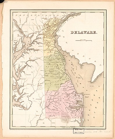
English: General content map of the State of Delaware showing minor civil division names and boundaries/names of the hundreds (townships). Hand colored to distinguish the counties. Prime meridian: Washington D.C.--"Longitude east from Washington". Map sheet removed from T.G. Bradford's 1838 atlas of the United States. "Entered according to Act of Congress in the year 1838 by T.G. Bradford in the Clerks Office of the District Court of Massachusetts." Laminated and mounted on cloth backing. Accompanied by reduced-scale photocopy of the atlas title page: An illustrated atlas, geographical, statistical, and historical, of the United States and the adjacent countries / by T.G. Bradford. 12 x 10 cm. Available also through the Library of Congress Web site as a raster image. 2 copies |
||
| Title | Delaware | ||
| Shelf ID | G3830 1838 .B7 G3830 1838 .B7 Copy 2 | ||
| Date | |||
| Source | https://www.loc.gov/item/2017593558/ | ||
| Author | Bradford, T. G. (Thomas Gamaliel); Lucas, Fielding; Boynton, George W.; E.S. Grant & Co. | ||
| Permission (Reusing this file) |
|
||
| Other versions |
|
||
| Location | United States · Delaware · Delaware. | ||
| Part of | American Memory · General Maps · Catalog · Geography And Map Division | ||
| Subject | United States · Maps · Delaware · Administrative And Political Divisions |


Licensing
[edit]
|
This is a faithful photographic reproduction of a two-dimensional, public domain work of art. The work of art itself is in the public domain for the following reason:
The official position taken by the Wikimedia Foundation is that "faithful reproductions of two-dimensional public domain works of art are public domain".
This photographic reproduction is therefore also considered to be in the public domain in the United States. In other jurisdictions, re-use of this content may be restricted; see Reuse of PD-Art photographs for details. | ||||
File history
Click on a date/time to view the file as it appeared at that time.
| Date/Time | Thumbnail | Dimensions | User | Comment | |
|---|---|---|---|---|---|
| current | 03:15, 6 June 2018 | | 4,056 × 4,908 (2.26 MB) | Fæ (talk | contribs) | LOC Maps https://www.loc.gov/item/2017593558/ #21391 |
You cannot overwrite this file.
File usage on Commons
The following page uses this file: