File:Deforestation at São Felix de Balsas no MATOPIBA (Maranhão - Tocantins - Piauí - Bahia).jpg
Jump to navigation
Jump to search
Size of this preview: 800 × 453 pixels. Other resolutions: 320 × 181 pixels | 640 × 362 pixels | 1,024 × 580 pixels | 1,280 × 725 pixels | 3,415 × 1,933 pixels.
Original file (3,415 × 1,933 pixels, file size: 4.02 MB, MIME type: image/jpeg)
Captions
Captions
Add a one-line explanation of what this file represents
Summary
[edit].jpg&action=edit§ion=1)
| Description |
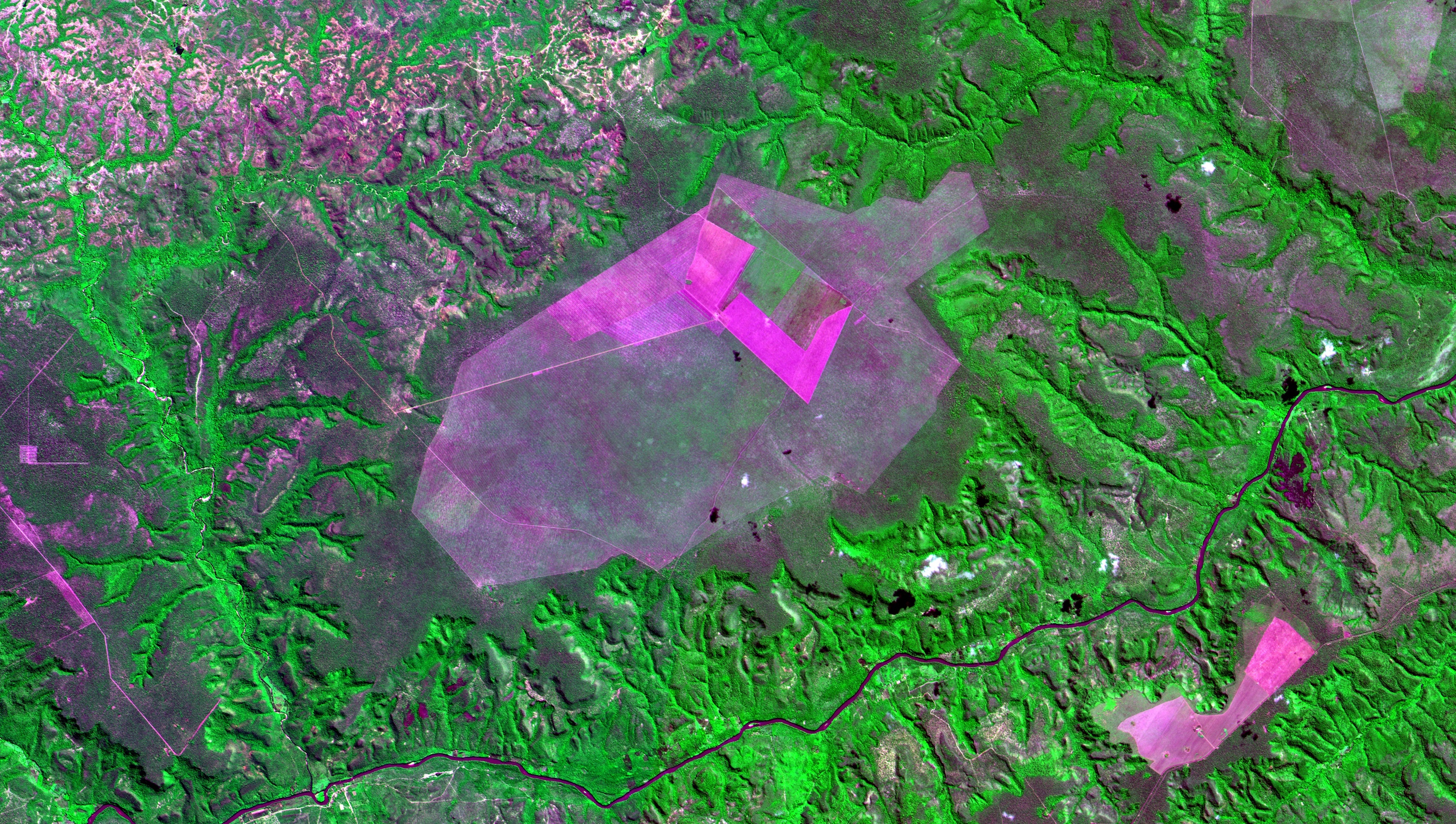
English: Desmatamento recente no cerrado em São Felix de Balsas no MATOPIBA (Maranhão - Tocantins - Piauí - Bahia), detectado pelo alerta Deter Cerrado do INPE em 25/05/2018 e aqui imageado em 03/06/2018. Em rosa solo exposto. Em roxo claro esverdeado, desmatamento recente. Em verde limão vegetação dos vales ao redor da chapada / Recent savanna deforestation at São Felix de Balsas, MATOPIBA region (Maranhão - Tocantins - Piauí - Bahia), detected by INPE´s Deter Cerrado Alert at 2018/25/05 and here imaged at 2018/03/06. Exposed soil in pink. Recent deforestation in greenish rosy purple. Plateau surrounding valleys vegetation in dayglo green.
+info 1) Programa "Meio Ambiente por Inteiro" da TV Justiça "A Devastação do Cerrado" / TV Program 2) Projeto Monitoramento Cerrado 3) Mapa interativo / Map
Imagem / Image CBERS4 PAN10m São Felix de Balsas, Maranhão Coordenadas do centro da imagem / Image center: 7°25'33.4"S 45°02'17.8"W Data / Date: 03-06-2018 / 2018-03-06 RGB 342 (falsa cor / false color) Cena / Scene: 157 / 108 Autor / Author: Oton Barros (DSR/OBT/INPE) Imagem em HD / HD Image Visite-nos / Visit us: www.dsr.inpe.br |
| Date | |
| Source | https://www.flickr.com/photos/153282474@N02/46092454461/ |
| Author | Coordenação-Geral de Observação da Terra/INPE |
Licensing
[edit].jpg&action=edit§ion=2)
This file is licensed under the Creative Commons Attribution-Share Alike 2.0 Generic license.
- You are free:
- to share – to copy, distribute and transmit the work
- to remix – to adapt the work
- Under the following conditions:
- attribution – You must give appropriate credit, provide a link to the license, and indicate if changes were made. You may do so in any reasonable manner, but not in any way that suggests the licensor endorses you or your use.
- share alike – If you remix, transform, or build upon the material, you must distribute your contributions under the same or compatible license as the original.
| This image was originally posted to Flickr by Coordenação-Geral de Observação da Terra/INPE at https://flickr.com/photos/153282474@N02/46092454461. It was reviewed on 9 April 2020 by FlickreviewR 2 and was confirmed to be licensed under the terms of the cc-by-sa-2.0. |
File history
Click on a date/time to view the file as it appeared at that time.
| Date/Time | Thumbnail | Dimensions | User | Comment | |
|---|---|---|---|---|---|
| current | 10:14, 9 April 2020 | | 3,415 × 1,933 (4.02 MB) | Jo-Jo Eumerus (talk | contribs) | Uploaded a work by Coordenação-Geral de Observação da Terra/INPE from https://www.flickr.com/photos/153282474@N02/46092454461/ with UploadWizard |
You cannot overwrite this file.
File usage on Commons
The following page uses this file:
_(46092454461).jpg&redirect=no)
.jpg&oldid=859248133)