File:Deep Impact IR-spectrometer.jpg
From Wikimedia Commons, the free media repository
Jump to navigation
Jump to search

Size of this preview: 800 × 540 pixels. Other resolutions: 320 × 216 pixels | 640 × 432 pixels | 1,024 × 691 pixels | 1,280 × 864 pixels | 3,000 × 2,025 pixels.
Original file (3,000 × 2,025 pixels, file size: 387 KB, MIME type: image/jpeg)
File information
Structured data
Captions
Captions
Add a one-line explanation of what this file represents
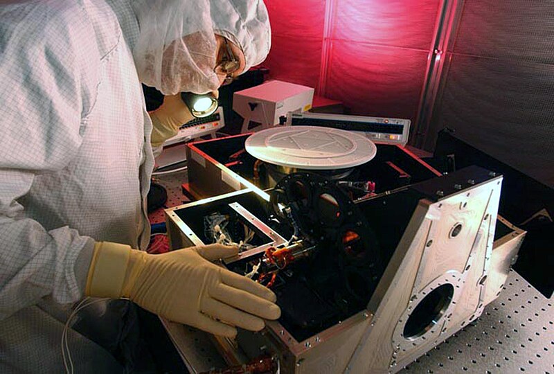
| DescriptionDeep Impact IR-spectrometer.jpg | At Ball Aerospace in Boulder, Colo., the infrared (IR) spectrometer for the Deep Impact flyby spacecraft is inspected in the instrument assembly area in the Fisher Assembly building clean room. Deep Impact will probe beneath the surface of Comet Tempel 1 on July 4, 2005, when the comet is 83 million miles from Earth, and reveal the secrets of its interior. After releasing a 3- by 3-foot projectile to crash onto the surface, Deep Impact’s flyby spacecraft will collect pictures and data of how the crater forms, measuring the crater’s depth and diameter, as well as the composition of the interior of the crater and any material thrown out, and determining the changes in natural outgassing produced by the impact. The spectrometer is part of the High Resolution Instrument in the spacecraft. This imager will be aimed at the ejected matter as the crater forms, and an infrared "fingerprint" of the material from inside of the comet's nucleus will be taken. It will send the data back to Earth through the antennas of the Deep Space Network. Deep Impact is a NASA Discovery mission. Launch of Deep Impact is scheduled for Jan. 12 from Launch Pad 17-B, Cape Canaveral Air Force Station, Fla. |
| Date |
before 10 January 2005 date QS:P,+2005-01-10T00:00:00Z/7,P1326,+2005-01-10T00:00:00Z/11 |
| Source | |
| Author | NASA |
This image or video was catalogued by Kennedy Space Center of the United States National Aeronautics and Space Administration (NASA) under Photo ID: KSC-05PD-0113 and Alternate ID: 05pd0113. This tag does not indicate the copyright status of the attached work. A normal copyright tag is still required. See Commons:Licensing. Other languages:
العربية ∙ беларуская (тарашкевіца) ∙ български ∙ català ∙ čeština ∙ dansk ∙ Deutsch ∙ English ∙ español ∙ فارسی ∙ français ∙ galego ∙ magyar ∙ հայերեն ∙ Bahasa Indonesia ∙ italiano ∙ 日本語 ∙ македонски ∙ മലയാളം ∙ Nederlands ∙ polski ∙ português ∙ русский ∙ sicilianu ∙ slovenščina ∙ Türkçe ∙ українська ∙ 简体中文 ∙ 繁體中文 ∙ +/− |
| Camera location | 34° 12′ 02.72″ N, 118° 10′ 19.41″ W | View this and other nearby images on: OpenStreetMap |
|---|
| Public domainPublic domainfalsefalse |
| This file is in the public domain in the United States because it was solely created by NASA. NASA copyright policy states that "NASA material is not protected by copyright unless noted". (See Template:PD-USGov, NASA copyright policy page or JPL Image Use Policy.) |  | |
 |
Warnings:
|
File history
Click on a date/time to view the file as it appeared at that time.
| Date/Time | Thumbnail | Dimensions | User | Comment | |
|---|---|---|---|---|---|
| current | 22:11, 9 July 2005 |  | 3,000 × 2,025 (387 KB) | Bricktop (talk | contribs) |
You cannot overwrite this file.
File usage on Commons
The following 2 pages use this file:
File usage on other wikis
The following other wikis use this file:
- Usage on de.wikipedia.org
- Usage on www.wikidata.org