File:Decker Fire in Chaffee County, Colorado (MODIS 2019-10-05).jpg
Original file (2,127 × 1,810 pixels, file size: 1.25 MB, MIME type: image/jpeg)
Captions
Captions
Summary
[edit].jpg&action=edit§ion=1)
| Description |
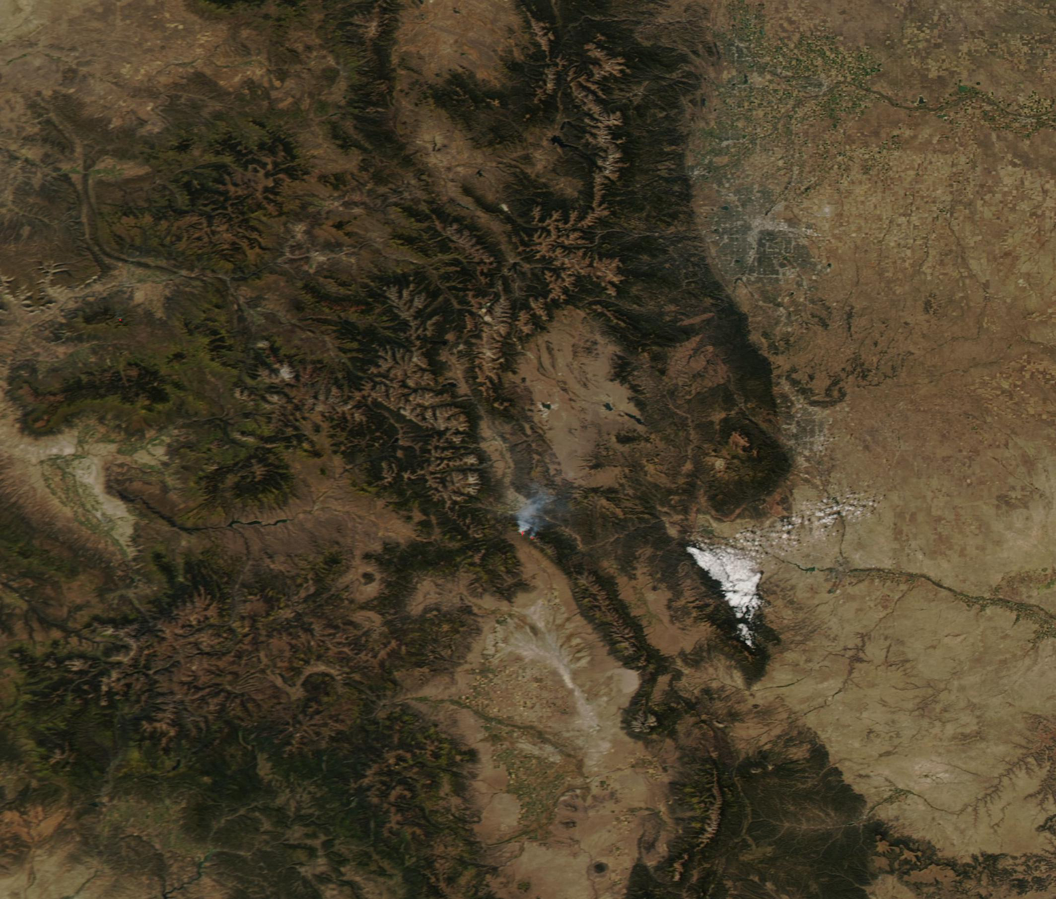
English: On September 8, 2019, a lightning strike ignited timber, litter and understory in the Sangre de Cristo Wilderness only 2 miles south of the town of Salida, Colorado. The fire smoldered at a relatively low level until the early days of October, when strong winds kicked up. Extremely low humidity and gusting winds fed rapid spread, causing the rapid mid-night evacuation of more than 100 families due to concerns of possible approach of the flames.
On October 4, 2019, Inciweb Incident Information System reported that the Decker fire had expanded to 5,824 acres and remains roughly 2 miles south of Salida. It is burning in moderate stocked mixed conifer with timber litter and light to moderate dead and downed trees. The stand has standing dead mixed with live conifer as well as dead and down pinion stands. The stands are over-mature and will burn actively through the crowns with higher winds and topography. The expanding fire has been described as active, with uphill runs, group torching and flanking. The fire spread has been primarily slope driven in the last 24 hours. The fire remains at only 5 percent contained, with 458 total personnel working the fire. The estimated containment date is projected to be December 20. While incoming high pressure on the night of October 3 brought some small amount of moisture, slowing spread, October 4 saw near-critical fire weather conditions in the region. Red Flag warning conditions are expected on October 5. The Moderate Resolution Imaging Spectroradiometer (MODIS) on board NASA’s Terra satellite acquired a true-color image of the Decker fire on October 3, 2019. Red hot spots mark areas where the thermal bands on the instrument detected high temperatures. When combined with typical smoke, as in this image, such hot spots mark actively burning fire. The smoke rises from the fire and is blowing to the northeast. |
||
| Date | 5 October 2019 (upload date) | ||
| Source |
Decker Fire in Chaffee County, Colorado (direct link)
|
||
| Author | MODIS Land Rapid Response Team, NASA GSFC |
| This media is a product of the Terra mission Credit and attribution belongs to the mission team, if not already specified in the "author" row |
Licensing
[edit].jpg&action=edit§ion=2)
| This file is in the public domain in the United States because it was solely created by NASA. NASA copyright policy states that "NASA material is not protected by copyright unless noted". (See Template:PD-USGov, NASA copyright policy page or JPL Image Use Policy.) | ||
 |
Warnings:
|
File history
Click on a date/time to view the file as it appeared at that time.
| Date/Time | Thumbnail | Dimensions | User | Comment | |
|---|---|---|---|---|---|
| current | 03:00, 17 February 2024 | | 2,127 × 1,810 (1.25 MB) | OptimusPrimeBot (talk | contribs) | #Spacemedia - Upload of http://modis.gsfc.nasa.gov/gallery/images/image10052019_250m.jpg via Commons:Spacemedia |
You cannot overwrite this file.
File usage on Commons
There are no pages that use this file.
.jpg&oldid=852714041)