File:Debitage (FindID 978129).jpg

Original file (2,974 × 3,772 pixels, file size: 3.44 MB, MIME type: image/jpeg)
Captions
Captions
Summary
[edit].jpg&action=edit§ion=1)
| Debitage | |||
|---|---|---|---|
| Photographer |
The Portable Antiquities Scheme, Megan Gard, 2019-11-04 13:21:05 |
||
| Title |
Debitage |
||
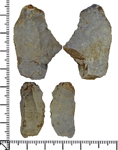
| Description |
English: One secondary and one tertiary flint waste flakes. Both are of opaque mid grey to beige flint with a low-gloss patina. A] The striking platform and bulb of percussion are missing. There is a hinge fracture at the distal end on the ventral face. It retains a small area of abraded cortex at the distal end on the dorsal face. A fault in the flint has caused the ventral face to fracture irregularly. There is some post-depositional edge damage. |
||
| Depicted place | (County of findspot) Dorset | ||
| Date | between 4000 BC and 1600 BC | ||
| Accession number |
FindIdentifier: 978129 |
||
| Credit line |
|
||
| Source |
https://finds.org.uk/database/ajax/download/id/1079478 Catalog: https://finds.org.uk/database/images/image/id/1079478/recordtype/artefacts archive copy at the Wayback Machine Artefact: https://finds.org.uk/database/artefacts/record/id/978129 |
||
| Permission (Reusing this file) |
Attribution License | ||
| Object location | | View this and other nearby images on: OpenStreetMap |
|---|
.jpg¶ms=050.820800_N_-002.272170_E_globe:Earth_class:object_type:object__&language=en)
Licensing
[edit].jpg&action=edit§ion=2)
- You are free:
- to share – to copy, distribute and transmit the work
- to remix – to adapt the work
- Under the following conditions:
- attribution – You must give appropriate credit, provide a link to the license, and indicate if changes were made. You may do so in any reasonable manner, but not in any way that suggests the licensor endorses you or your use.
File history
Click on a date/time to view the file as it appeared at that time.
| Date/Time | Thumbnail | Dimensions | User | Comment | |
|---|---|---|---|---|---|
| current | 13:15, 21 November 2020 | | 2,974 × 3,772 (3.44 MB) | Fæ (talk | contribs) | Portable Antiquities Scheme, DOR, FindID: 978129-1079478, neolithic, page 1158, batch count 4829 |
You cannot overwrite this file.
File usage on Commons
The following page uses this file:
.jpg)
.jpg&oldid=549423370)