File:Deadly landslide in jade mine - Hpakant, Kachin State, Myanmar.jpg
Original file (3,508 × 2,540 pixels, file size: 6.89 MB, MIME type: image/jpeg)
Captions
Captions
Summary
[edit]
| Description |
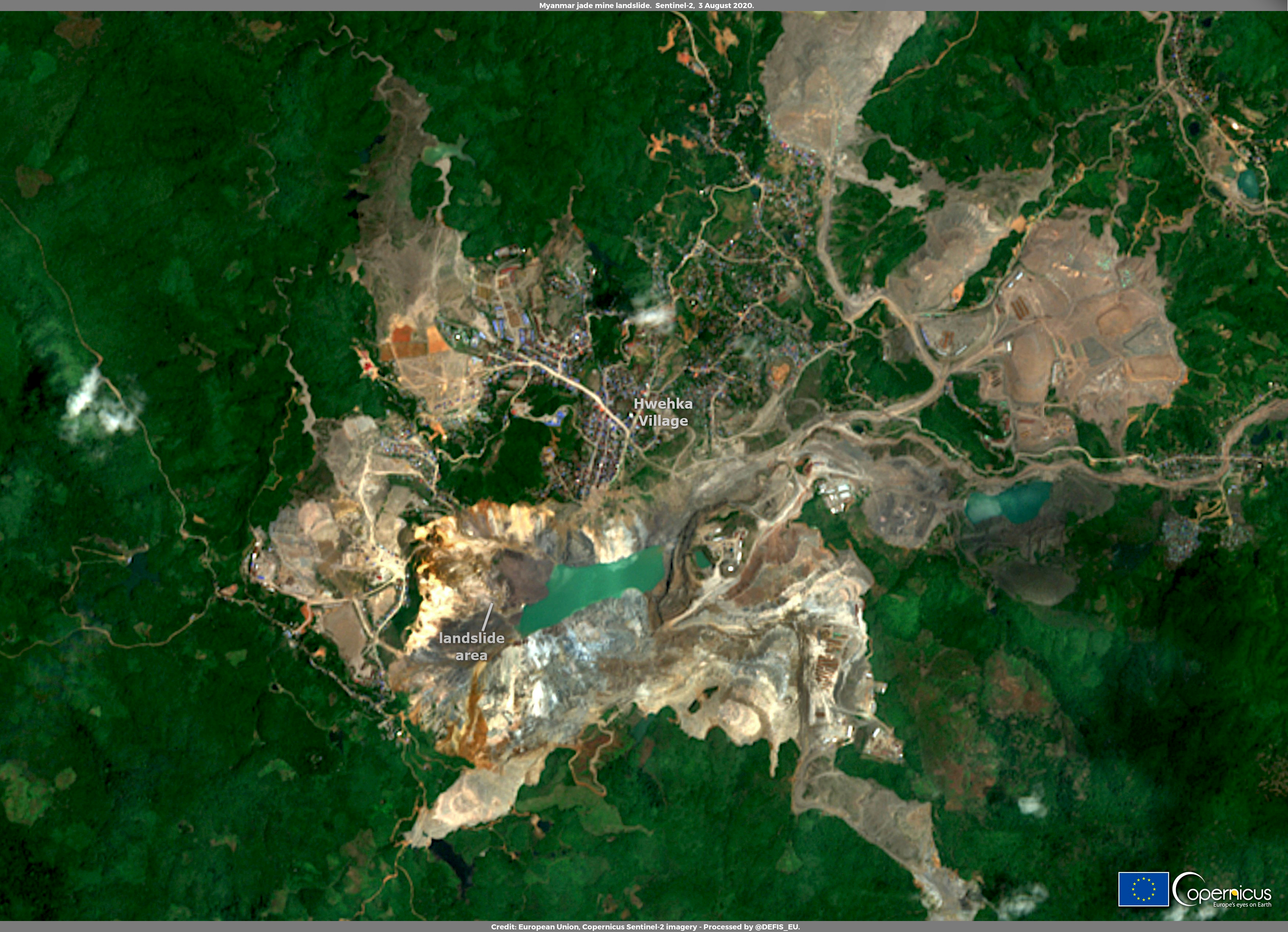
English: On 2 July a massive landslide caused at least 162 fatalities amongst miners that were working in a jade mining site in the state of Kachin, in Myanmar. A landslide triggered by heavy rain sent a wave of mud and rock towards jade pickers working in the pits. Myanmar is the world's largest producer of jade, and even if dangerous landslides occur almost every year during the rainy season in the vast mining sites in Kachin state, last month's landslide was the deadliest on record. This image shows the mine site impacted by the landslide as captured by one of the Copernicus Sentinel-2 satellites on 3 August, when the first cloud free view of the scene since the day of the accident has been acquired. It is clearly visible that the rock and mud from the landslide poured into the lake formed as a consequence of strong rains typical of the monsoon season. The Copernicus Sentinel-2 mission, which is composed of two twin satellites, Sentinel-2A and Sentinel-2B, provides multispectral imagery with 13 different spectral band at a maximum spatial resolution of 10m. These multispectral data allow to implement effective landslide mapping applications with a combined processing of images capturing the area of interest before and after the landslide event. |
| Date | 5 August 2020 (upload date) |
| Source | Deadly landslide in jade mine - Hpakant, Kachin State, Myanmar |
| Author | European Union , Copernicus Sentinel-2 imagery |
Licensing
[edit]

|
This image contains data from a satellite in the Copernicus Programme, such as Sentinel-1, Sentinel-2 or Sentinel-3. Attribution is required when using this image.
Attribution: Contains modified Copernicus Sentinel data 2020
The use of Copernicus Sentinel Data is regulated under EU law (Commission Delegated Regulation (EU) No 1159/2013 and Regulation (EU) No 377/2014). Relevant excerpts:
Free access shall be given to GMES dedicated data [...] made available through GMES dissemination platforms [...].
Access to GMES dedicated data [...] shall be given for the purpose of the following use in so far as it is lawful:
GMES dedicated data [...] may be used worldwide without limitations in time.
GMES dedicated data and GMES service information are provided to users without any express or implied warranty, including as regards quality and suitability for any purpose. |
File history
Click on a date/time to view the file as it appeared at that time.
| Date/Time | Thumbnail | Dimensions | User | Comment | |
|---|---|---|---|---|---|
| current | 15:53, 29 July 2023 | | 3,508 × 2,540 (6.89 MB) | OptimusPrimeBot (talk | contribs) | #Spacemedia - Upload of https://www.copernicus.eu/system/files/2020-08/image_day/Birmania_credit_row.jpg via Commons:Spacemedia |
You cannot overwrite this file.
File usage on Commons
There are no pages that use this file.
File usage on other wikis
The following other wikis use this file:
- Usage on www.wikidata.org