File:Das Grossherzogthum Baden 1832 Friedrich Wilhelm Streit.jpg
Jump to navigation
Jump to search
Size of this preview: 456 × 599 pixels. Other resolutions: 183 × 240 pixels | 365 × 480 pixels | 584 × 768 pixels | 779 × 1,024 pixels | 1,558 × 2,048 pixels | 4,511 × 5,928 pixels.
Original file (4,511 × 5,928 pixels, file size: 17.42 MB, MIME type: image/jpeg)
Captions
Captions
Add a one-line explanation of what this file represents
Summary
[edit]| Description |
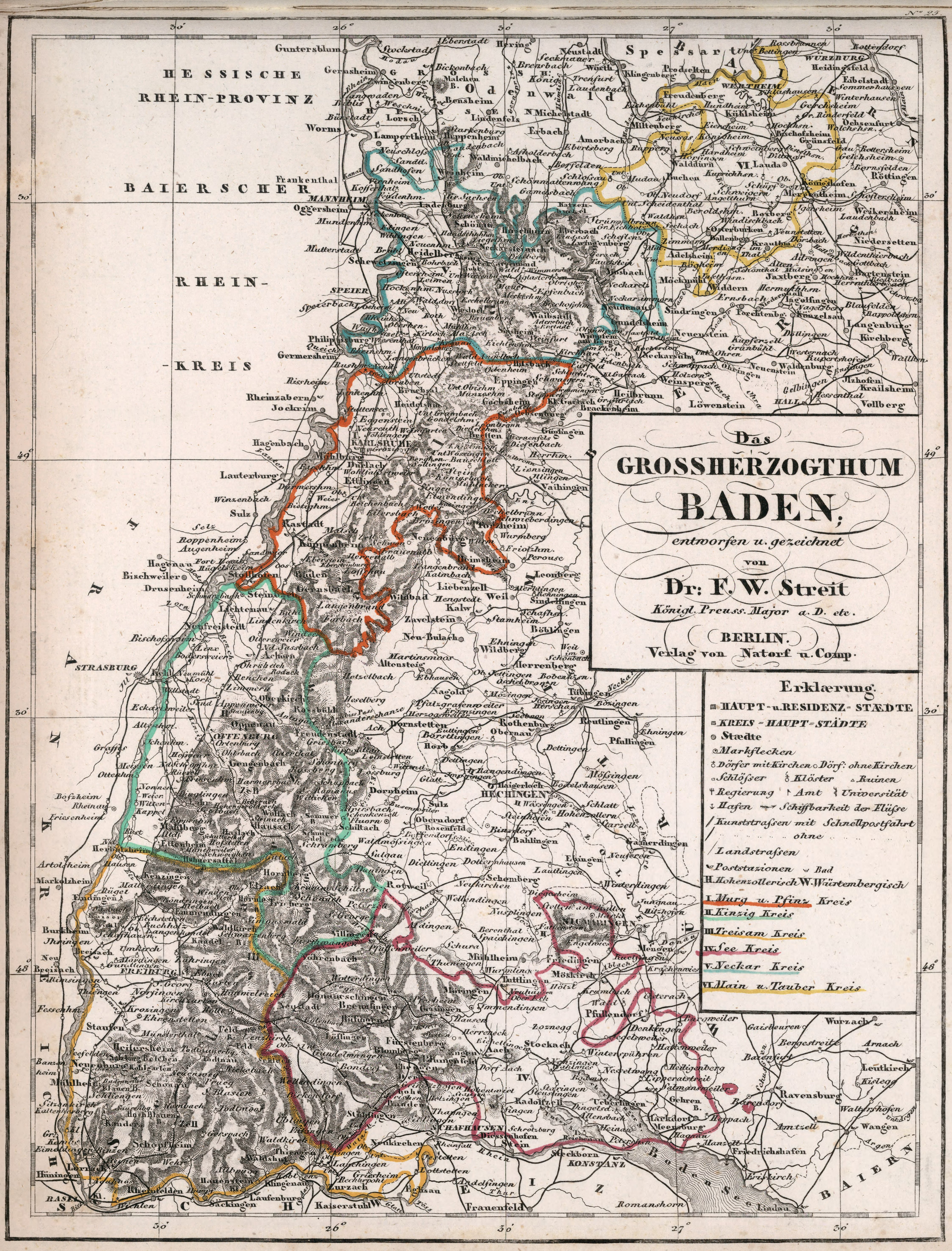
Deutsch: Karte des Großherzogtums Baden mit den vor 1832 gültigen Verwaltungsgrenzen. Eingezeichnet sind die folgenden 6 Kreise (von oben nach unten):
English: Map of the Grand Duchy of Baden, with administrative units before 1832 |
| Date | circa 1830 |
| Source | David Eumsey Map Collection |
| Author | Friedrich Wilhelm Streit, 1772-1839 |
| Other versions |

_Baden_1832_Friedrich_Wilhelm_Streit.jpg)
_Baden_1832_Friedrich_Wilhelm_Streit.jpg)
_Baden_1832_Friedrich_Wilhelm_Streit.jpg)
_Baden_1832_Friedrich_Wilhelm_Streit.jpg)
_Baden_1832_Friedrich_Wilhelm_Streit.jpg)
_Baden_1832_Friedrich_Wilhelm_Streit.jpg)
Licensing
[edit]
|
This work is in the public domain in its country of origin and other countries and areas where the copyright term is the author's life plus 70 years or fewer. This work is in the public domain in the United States because it was published (or registered with the U.S. Copyright Office) before January 1, 1929. | |
| This file has been identified as being free of known restrictions under copyright law, including all related and neighboring rights. | |
File history
Click on a date/time to view the file as it appeared at that time.
| Date/Time | Thumbnail | Dimensions | User | Comment | |
|---|---|---|---|---|---|
| current | 15:47, 15 September 2022 | | 4,511 × 5,928 (17.42 MB) | Kallewirsch (talk | contribs) | Uploaded a work by Friedrich Wilhelm Streit, 1772-1839 from [https://www.davidrumsey.com/luna/servlet/detail/RUMSEY~8~1~314292~90083497:Das-Grossherzogthum-Baden?sort=pub_list_no_initialsort%2Cpub_date%2Cpub_list_no%2Cseries_no# David Eumsey Map Collection] with UploadWizard |
You cannot overwrite this file.
File usage on Commons
The following 7 pages use this file:
- File:Dreisamkreis (1809–1832) Baden 1832 Friedrich Wilhelm Streit.jpg
- File:Kinzigkreis (1809–1832) Baden 1832 Friedrich Wilhelm Streit.jpg
- File:Main- und Tauberkreis (1809–1832) Baden 1832 Friedrich Wilhelm Streit.jpg
- File:Murg- und Pfinzkreis (1819–1832) Baden 1832 Friedrich Wilhelm Streit.jpg
- File:Neckarkreis (1809–1832) Baden 1832 Friedrich Wilhelm Streit.jpg
- File:Neckarkreis Baden 1832 Friedrich Wilhelm Streit.jpg
- File:Seekreis (1809–1832) Baden 1832 Friedrich Wilhelm Streit.jpg