File:Dartmouth College campus - diagram of the Green.svg
Jump to navigation
Jump to search

Size of this PNG preview of this SVG file: 427 × 599 pixels. Other resolutions: 171 × 240 pixels | 342 × 480 pixels | 547 × 768 pixels | 730 × 1,024 pixels | 1,460 × 2,048 pixels | 710 × 996 pixels.
Original file (SVG file, nominally 710 × 996 pixels, file size: 116 KB)
Captions
Captions
Add a one-line explanation of what this file represents
Summary
[edit]
This W3C-unspecified vector image was created with Inkscape .
| Description |
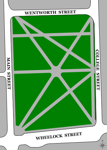
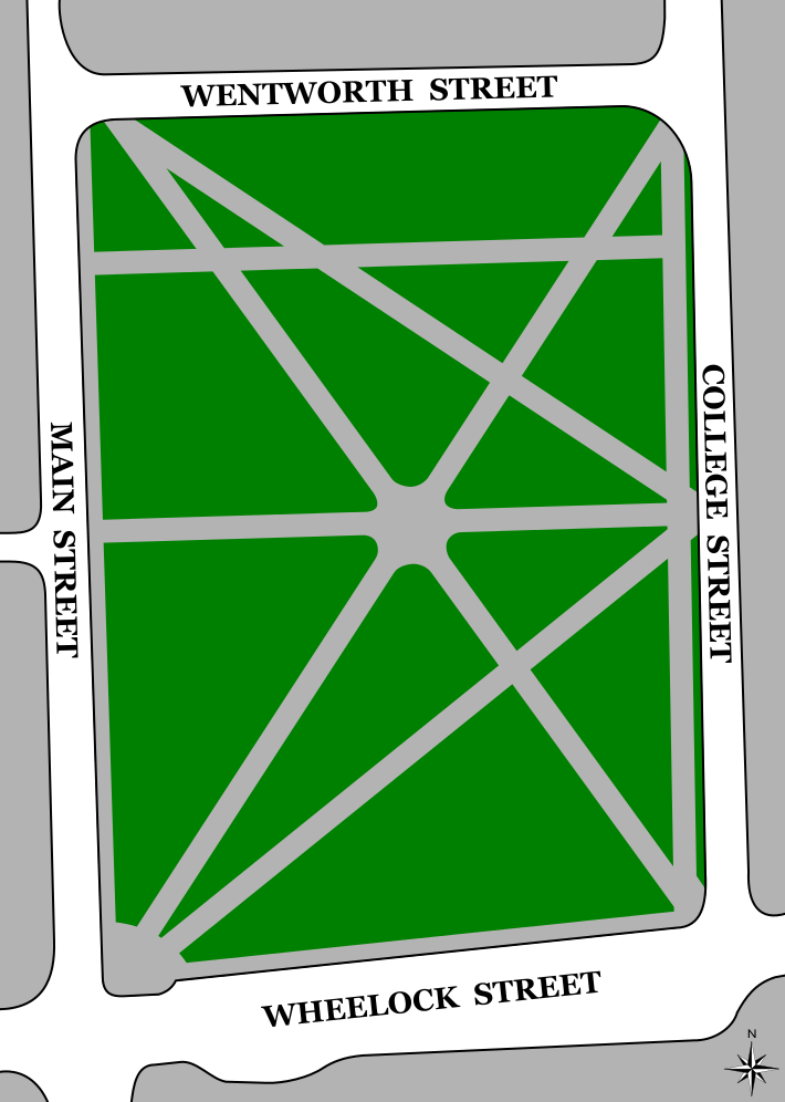
English: A diagram of The Green at Dartmouth College in Hanover, New Hampshire. Based on the school's official map and the Google Earth satellite image of the area, but it is my own composition. The compass rose in the corner was isolated and added from Image:Windrose.svg. |
| Date | November 2, 2007 |
| Source | Own work |
| Author | Kane5187 |
| Other versions | Image:Dartmouth College campus - diagram of the Green.jpg - the original, raster version |
Licensing
[edit]
| This work has been released into the public domain by its author, I, Kane5187. This applies worldwide. In some countries this may not be legally possible; if so: I, Kane5187 grants anyone the right to use this work for any purpose, without any conditions, unless such conditions are required by law. |
File history
Click on a date/time to view the file as it appeared at that time.
| Date/Time | Thumbnail | Dimensions | User | Comment | |
|---|---|---|---|---|---|
| current | 07:42, 25 November 2007 | | 710 × 996 (116 KB) | Kane5187 (talk | contribs) | Fixing NW corner |
| 06:41, 25 November 2007 |  | 710 × 996 (116 KB) | Kane5187 (talk | contribs) | Moving N | |
| 06:40, 25 November 2007 |  | 710 × 996 (116 KB) | Kane5187 (talk | contribs) | Adding a small compass rose | |
| 06:23, 25 November 2007 |  | 710 × 996 (112 KB) | Kane5187 (talk | contribs) | Cleaning up a whole lot, now that I know about Inkscape a bit more | |
| 23:52, 4 November 2007 |  | 1,879 × 2,632 (114 KB) | Kane5187 (talk | contribs) | Forgot to re-thicken the border | |
| 18:28, 3 November 2007 |  | 1,879 × 2,632 (113 KB) | Kane5187 (talk | contribs) | Replacing circle at the center of the Green with a more accurate figure; moving easternmost north-south path over closer to College Street, as more accurate | |
| 19:38, 2 November 2007 |  | 1,879 × 2,632 (112 KB) | Kane5187 (talk | contribs) | recentering circle at the center | |
| 19:24, 2 November 2007 |  | 1,879 × 2,632 (111 KB) | Kane5187 (talk | contribs) | adding Cemetery Lane, which I forgot | |
| 19:12, 2 November 2007 |  | 1,879 × 2,632 (110 KB) | Kane5187 (talk | contribs) | Making the roads not transparent | |
| 18:36, 2 November 2007 |  | 1,879 × 2,632 (110 KB) | Kane5187 (talk | contribs) | straighting an edge |
You cannot overwrite this file.
File usage on Commons
The following page uses this file:
File usage on other wikis
The following other wikis use this file:
- Usage on en.wikipedia.org
- Usage on pt.wikipedia.org