File:Dartford, Fastrack busway shelters - geograph.org.uk - 725165.jpg
Jump to navigation
Jump to search
No higher resolution available.
Dartford,_Fastrack_busway_shelters_-_geograph.org.uk_-_725165.jpg (640 × 480 pixels, file size: 66 KB, MIME type: image/jpeg)
Captions
Captions
Add a one-line explanation of what this file represents
Summary
[edit]
| Description |
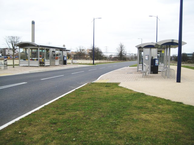
English: Dartford: Fastrack busway shelters See 724887 for information about the busway and a link to the Fastrack site. These shelters are on the dedicated busway route between Joyce Green Lane and the Crossway Boulevard and have been constructed to eventually serve The Bridge development here on the site of the former Joyce Green Hospital. However at the present their swish stainless steelness resides in total isolation from humanity without a building, and therefore passengers, within about 500 metres. One wonders if they will withstand vandalism and the construction site works before they actually serve the purpose for which they were designed... The chimney of 724919 inevitably looms over the scene. |
| Date | |
| Source | From geograph.org.uk |
| Author | Nigel Cox |
| Attribution (required by the license) | Nigel Cox / Dartford: Fastrack busway shelters / |
| Camera location | | View this and other nearby images on: OpenStreetMap |
|---|
_heading:67.00&language=en)
| Object location | | View this and other nearby images on: OpenStreetMap |
|---|
_heading:67.00&language=en)
Licensing
[edit]

|
This image was taken from the Geograph project collection. See this photograph's page on the Geograph website for the photographer's contact details. The copyright on this image is owned by Nigel Cox and is licensed for reuse under the Creative Commons Attribution-ShareAlike 2.0 license.
|
This file is licensed under the Creative Commons Attribution-Share Alike 2.0 Generic license.
Attribution: Nigel Cox
- You are free:
- to share – to copy, distribute and transmit the work
- to remix – to adapt the work
- Under the following conditions:
- attribution – You must give appropriate credit, provide a link to the license, and indicate if changes were made. You may do so in any reasonable manner, but not in any way that suggests the licensor endorses you or your use.
- share alike – If you remix, transform, or build upon the material, you must distribute your contributions under the same or compatible license as the original.
File history
Click on a date/time to view the file as it appeared at that time.
| Date/Time | Thumbnail | Dimensions | User | Comment | |
|---|---|---|---|---|---|
| current | 04:26, 19 February 2011 | | 640 × 480 (66 KB) | GeographBot (talk | contribs) | == {{int:filedesc}} == {{Information |description={{en|1=Dartford: Fastrack busway shelters See 724887 for information about the busway and a link to the Fastrack site. These shelters are on the dedicated busway route between Joyce Green Lane and the |
You cannot overwrite this file.
File usage on Commons
There are no pages that use this file.