File:Darßer Ort Leuchtturm 2013-09-04 29.JPG
Original file (2,112 × 2,816 pixels, file size: 2.8 MB, MIME type: image/jpeg)
Captions
DescriptionDarßer Ort Leuchtturm 2013-09-04 29.JPG |
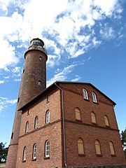
Deutsch: Leuchtturm in Darßer Ort im Landkreis Vorpommern-Rügen, Mecklenburg-Vorpommern, Deutschland
English: Lighthouse in Darßer Ort, district Vorpommern-Rügen, Mecklenburg-Vorpommern, Germany |
Date | |
Source | Self-photographed |
Author | Niteshift |
Permission (Reusing this file) |
I, the copyright holder of this work, hereby publish it under the following license: This file is licensed under the Creative Commons Attribution-Share Alike 3.0 Unported license.
|
Camera location | 54° 28′ 21.5″ N, 12° 30′ 09.47″ E | View this and other nearby images on: OpenStreetMap | 54.472640; 12.502630 |
---|
This image was uploaded as part of Wiki Loves Monuments 2013.
Afrikaans ∙ Alemannisch ∙ العربية ∙ جازايرية ∙ azərbaycanca ∙ Bikol Central ∙ беларуская ∙ беларуская (тарашкевіца) ∙ български ∙ বাংলা ∙ brezhoneg ∙ bosanski ∙ català ∙ čeština ∙ Cymraeg ∙ dansk ∙ Deutsch ∙ Zazaki ∙ Ελληνικά ∙ English ∙ Esperanto ∙ español ∙ eesti ∙ euskara ∙ فارسی ∙ suomi ∙ français ∙ Frysk ∙ Gaeilge ∙ galego ∙ עברית ∙ हिन्दी ∙ hrvatski ∙ magyar ∙ հայերեն ∙ Bahasa Indonesia ∙ Ido ∙ italiano ∙ 日本語 ∙ ქართული ∙ 한국어 ∙ кыргызча ∙ Lëtzebuergesch ∙ latviešu ∙ Malagasy ∙ македонски ∙ മലയാളം ∙ Bahasa Melayu ∙ Malti ∙ norsk bokmål ∙ नेपाली ∙ Nederlands ∙ norsk nynorsk ∙ norsk ∙ polski ∙ português ∙ português do Brasil ∙ română ∙ русский ∙ sicilianu ∙ davvisámegiella ∙ slovenčina ∙ slovenščina ∙ shqip ∙ српски / srpski ∙ svenska ∙ ไทย ∙ Tagalog ∙ Türkçe ∙ українська ∙ اردو ∙ oʻzbekcha / ўзбекча ∙ Yorùbá ∙ 中文 ∙ 中文(中国大陆) ∙ 中文(简体) ∙ 中文(繁體) ∙ 中文(香港) ∙ 中文(臺灣) ∙ +/− |
File history
Click on a date/time to view the file as it appeared at that time.
Date/Time | Thumbnail | Dimensions | User | Comment | |
---|---|---|---|---|---|
current | 20:30, 16 September 2013 | 2,112 × 2,816 (2.8 MB) | Niteshift (talk | contribs) | {{subst:User:Niteshift/MV |deobjekt=Leuchtturm |enobjekt=Lighthouse |Pos=in |enPos=in |Ort=Darßer Ort |Landkreis=Vorpommern-Rügen |Jahr=2013 |Monat=09 |Tag=04 |GPS={{GPS EXIF}} }} Category:Lighthouse Darßer Ort |
You cannot overwrite this file.
File usage on Commons
There are no pages that use this file.
Metadata
This file contains additional information such as Exif metadata which may have been added by the digital camera, scanner, or software program used to create or digitize it. If the file has been modified from its original state, some details such as the timestamp may not fully reflect those of the original file. The timestamp is only as accurate as the clock in the camera, and it may be completely wrong.
Camera manufacturer | Canon |
---|---|
Camera model | Canon PowerShot SX230 HS |
Exposure time | 1/500 sec (0.002) |
F-number | f/4 |
ISO speed rating | 100 |
Date and time of data generation | 15:09, 4 September 2013 |
Lens focal length | 5 mm |
Latitude | 54° 28′ 21.5″ N |
Longitude | 12° 30′ 9.47″ E |
Altitude | 1 meter above sea level |
Horizontal resolution | 180 dpi |
Vertical resolution | 180 dpi |
Software used | Paint.NET v3.5.11 |
File change date and time | 15:09, 4 September 2013 |
Y and C positioning | Co-sited |
Exif version | 2.3 |
Date and time of digitizing | 15:09, 4 September 2013 |
Meaning of each component |
|
Image compression mode | 3 |
APEX shutter speed | 8.96875 |
APEX aperture | 4 |
APEX exposure bias | 0 |
Maximum land aperture | 3.25 APEX (f/3.08) |
Metering mode | Pattern |
Flash | Flash did not fire, compulsory flash suppression |
Supported Flashpix version | 1 |
Color space | sRGB |
Focal plane X resolution | 11,540.983606557 |
Focal plane Y resolution | 11,540.983606557 |
Focal plane resolution unit | inches |
Sensing method | One-chip color area sensor |
File source | Digital still camera |
Custom image processing | Normal process |
Exposure mode | Auto exposure |
White balance | Auto white balance |
Digital zoom ratio | 1 |
Scene capture type | Landscape |
GPS time (atomic clock) | 13:09 |
Geodetic survey data used | WGS-84 |
GPS date | 4 September 2013 |
GPS tag version | 2.2.0.0 |
Structured data
Items portrayed in this file
depicts
4 September 2013
54°28'21.50"N, 12°30'9.47"E
0.002 second
5 millimetre
100
image/jpeg
7d6b3d6d929894c2e4eddcce7cdc9ed61cdcc498
2,934,476 byte
2,816 pixel
2,112 pixel
- CC-BY-SA-3.0
- Self-published work
- Files with coordinates missing SDC location of creation
- Images from Wiki Loves Monuments 2013
- Images from Wiki Loves Monuments 2013 in Germany
- Images from Wiki Loves Monuments missing SDC location of creation
- Files by User:Niteshift
- Images from Wiki Loves Monuments 2013, DE-MV
- Uploaded via Campaign:wlm-de-mv