File:Damage Macon County.JPG
Jump to navigation
Jump to search

No higher resolution available.
Damage_Macon_County.JPG (640 × 480 pixels, file size: 95 KB, MIME type: image/jpeg)
Captions
Captions
Add a one-line explanation of what this file represents
Summary
[edit]
| Description |
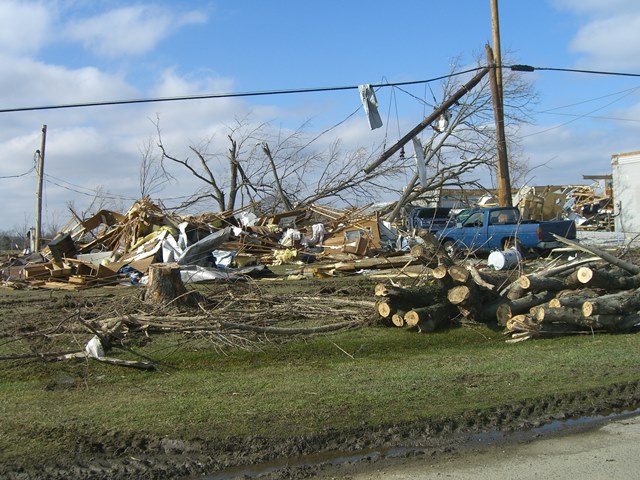
English: Severe damage was caused by an EF3 tornado that tore through a 50-mile path from northeast of Nashville to southern Kentucky. The image was taken by NWS Survey Team in Macon County, TN during the damage surveys. 22 were killed by this tornado, making it the deadliest tornado since the Evansville Tornado in November 2006. Courtesy of NWS Nashville, TN |
| Date | 4 March 2008 (original upload date) |
| Source | http://www.srh.noaa.gov/ohx/surveys/images/020508/macon_county/ss080205_macon.php Transferred from en.wikipedia to Commons by Atmoz using CommonsHelper. (dead link; now appears on https://www.weather.gov/ohx/20080205 (direct image link) |
| Author | The original uploader was JForget at English Wikipedia. |
| Camera location | | View this and other nearby images on: OpenStreetMap |
|---|
Licensing
[edit]
| This file is in the public domain in the United States because it was solely created by the National Weather Service (including its name from 1870–1970, the United States Weather Bureau).
As a file created by an employee of the NWS (formerly USWB) in the course of their official duties, whether hosted
this work is in the public domain in the United States because it is a work prepared by an officer or employee of the United States Government as part of that person’s official duties under the terms of Title 17, Chapter 1, Section 105 of the US Code. |
||
 |
Warnings:
|
Original upload log
[edit]
The original description page was here. All following user names refer to en.wikipedia.
- 2008-03-04 03:23 JForget 640×480× (97543 bytes) Severe damage was caused by an EF3 tornado that tore through a 50-mile path from northeast of Nashville to southern Kentucky. The image was taken by NWS Survey Team in Macon County, TN during the damage surveys. 22 were killed by this tornado, making it t
File history
Click on a date/time to view the file as it appeared at that time.
| Date/Time | Thumbnail | Dimensions | User | Comment | |
|---|---|---|---|---|---|
| current | 16:54, 5 August 2010 | | 640 × 480 (95 KB) | Atmoz (talk | contribs) | {{Information |Description={{en|Severe damage was caused by an EF3 tornado that tore through a 50-mile path from northeast of Nashville to southern Kentucky. The image was taken by NWS Survey Team in Macon County, TN during the damage surveys. 22 were kil |
You cannot overwrite this file.
File usage on Commons
There are no pages that use this file.