File:Dairy herd above Ringstead - geograph.org.uk - 266918.jpg
From Wikimedia Commons, the free media repository
Jump to navigation
Jump to search
Dairy_herd_above_Ringstead_-_geograph.org.uk_-_266918.jpg (640 × 480 pixels, file size: 78 KB, MIME type: image/jpeg)
File information
Structured data
Captions
Summary
[edit]DescriptionDairy herd above Ringstead - geograph.org.uk - 266918.jpg |
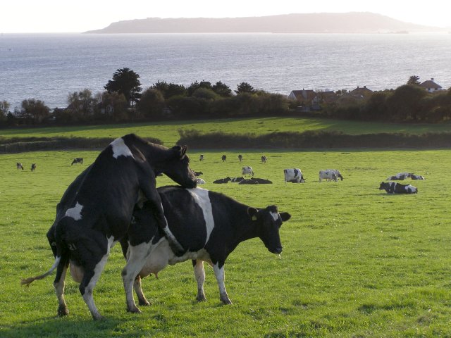
English: Dairy herd above Ringstead. A lot of the farmland in this area is used as dairy pasture - this particular herd is in a gently sloping field south of Ringstead Dairy. In the foreground a cow is indulging in a bit of domination over one of its peers. In the distance the Isle of Portland looms in the late afternoon haze. |
||
Date | |||
Source | geograph.org.uk | ||
Author | Jim Champion | ||
Permission (Reusing this file) |
This file is licensed under the Creative Commons Attribution-Share Alike 2.0 Generic license. Attribution: Jim Champion
|
||
Attribution (required by the license) InfoField | Jim Champion / Dairy herd above Ringstead / | ||
InfoField | Jim Champion / Dairy herd above Ringstead |
Object location | 50° 38′ 12″ N, 2° 20′ 49″ W | View this and other nearby images on: OpenStreetMap | 50.636700; -2.347000 |
---|
File history
Click on a date/time to view the file as it appeared at that time.
Date/Time | Thumbnail | Dimensions | User | Comment | |
---|---|---|---|---|---|
current | 15:26, 12 December 2010 | 640 × 480 (78 KB) | GeographBot (talk | contribs) | == {{int:filedesc}} == {{Information |description={{en|1=Dairy herd above Ringstead A lot of the farmland in this area is used as dairy pasture - this particular herd is in a gently sloping field south of Ringstead Dairy. In the foreground a cow is indul |
You cannot overwrite this file.
File usage on Commons
There are no pages that use this file.
Metadata
This file contains additional information such as Exif metadata which may have been added by the digital camera, scanner, or software program used to create or digitize it. If the file has been modified from its original state, some details such as the timestamp may not fully reflect those of the original file. The timestamp is only as accurate as the clock in the camera, and it may be completely wrong.
Image title | OLYMPUS DIGITAL CAMERA |
---|---|
Camera manufacturer | OLYMPUS IMAGING CORP. |
Camera model | SP500UZ |
Exposure time | 1/250 sec (0.004) |
F-number | f/4 |
ISO speed rating | 80 |
Date and time of data generation | 16:55, 24 October 2006 |
Lens focal length | 16.6 mm |
Orientation | Normal |
Horizontal resolution | 72 dpi |
Vertical resolution | 72 dpi |
Software used | Version 1.1 |
File change date and time | 16:55, 24 October 2006 |
Y and C positioning | Co-sited |
Exposure Program | Creative program (biased toward depth of field) |
Exif version | 2.21 |
Date and time of digitizing | 16:55, 24 October 2006 |
Image compression mode | 2 |
APEX exposure bias | 0 |
Maximum land aperture | 2.97 APEX (f/2.8) |
Metering mode | Pattern |
Light source | Unknown |
Flash | Flash did not fire, compulsory flash suppression |
Color space | sRGB |
Custom image processing | Normal process |
Exposure mode | Auto exposure |
White balance | Auto white balance |
Digital zoom ratio | 0 |
Scene capture type | Standard |
Contrast | Normal |
Saturation | Normal |
Sharpness | Normal |
Structured data
Items portrayed in this file
depicts
some value
24 October 2006
50°38'12.1"N, 2°20'49.2"W
0.004 second
16.6 millimetre
image/jpeg
53adfa56198c254719a0f1d87544513415a7b203
80,107 byte
480 pixel
640 pixel
Hidden categories:
- CC-BY-SA-2.0
- Images from Geograph Britain and Ireland
- Images from Geograph Britain and Ireland missing SDC coordinates of the point of view
- Information field template with formatting
- Files with coordinates missing SDC location of creation (50° N, 3° W)
- Images by Jim Champion
- United Kingdom photographs taken on 2006-10-24