File:Dagestan-tsumadinsky.png
Jump to navigation
Jump to search

Size of this preview: 419 × 599 pixels. Other resolutions: 168 × 240 pixels | 336 × 480 pixels | 537 × 768 pixels | 716 × 1,024 pixels | 2,000 × 2,860 pixels.
Original file (2,000 × 2,860 pixels, file size: 835 KB, MIME type: image/png)
Captions
Captions
Add a one-line explanation of what this file represents
Summary
[edit]
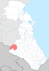
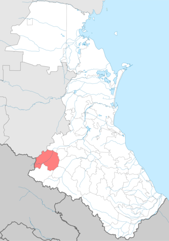
Tsumadinsky district in Dagestan map
Цумадинский район на карте Дагестана
| Description |
Suomi: Tsumadan piiri Dagestanin kartalla. |
| Date | |
| Source | Own work |
| Author | Koryakov Yuri |
Licensing
[edit]
| I, the copyright holder of this work, release this work into the public domain. This applies worldwide. In some countries this may not be legally possible; if so: I grant anyone the right to use this work for any purpose, without any conditions, unless such conditions are required by law. |
File history
Click on a date/time to view the file as it appeared at that time.
| Date/Time | Thumbnail | Dimensions | User | Comment | |
|---|---|---|---|---|---|
| current | 09:37, 14 July 2022 | | 2,000 × 2,860 (835 KB) | Takhirgeran Umar (talk | contribs) | . |
| 23:53, 13 July 2022 |  | 744 × 1,064 (221 KB) | Takhirgeran Umar (talk | contribs) | . | |
| 11:26, 19 September 2011 |  | 1,439 × 2,117 (138 KB) | Takhirgeran Umar (talk | contribs) | изменение границы Казбековского района | |
| 21:54, 26 February 2007 |  | 1,439 × 2,117 (49 KB) | Koryakov Yuri (talk | contribs) |
You cannot overwrite this file.
File usage on Commons
The following page uses this file:
File usage on other wikis
The following other wikis use this file:
- Usage on ar.wikipedia.org
- Usage on av.wikipedia.org
- Usage on ce.wikipedia.org
- Usage on cv.wikipedia.org
- Usage on en.wikipedia.org
- Usage on et.wikipedia.org
- Usage on fi.wikipedia.org
- Usage on hu.wikipedia.org
- Usage on hy.wikipedia.org
- Usage on it.wikipedia.org
- Usage on kk.wikipedia.org
- Usage on lez.wikipedia.org
- Usage on nl.wikipedia.org
- Usage on os.wikipedia.org
- Usage on pl.wikipedia.org
- Usage on ru.wikipedia.org
- Usage on ru.wikinews.org
- Usage on sco.wikipedia.org
- Usage on uk.wikipedia.org
- Usage on www.wikidata.org
- Usage on zh-min-nan.wikipedia.org