File:DXN Bridge over Missouri River.jpg
Jump to navigation
Jump to search

Size of this preview: 769 × 600 pixels. Other resolutions: 308 × 240 pixels | 616 × 480 pixels | 985 × 768 pixels | 1,280 × 998 pixels | 2,560 × 1,997 pixels | 4,709 × 3,673 pixels.
Original file (4,709 × 3,673 pixels, file size: 2.26 MB, MIME type: image/jpeg)
Captions
Captions
Add a one-line explanation of what this file represents
|
This is an image of a place or building that is listed on the National Register of Historic Places in the United States of America. Its reference number is 85000419. |
| Camera location | | View this and other nearby images on: OpenStreetMap |
|---|
| Description |
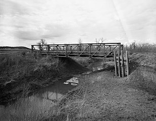
English: Southern side of the DXN Bridge over Missouri River, which carries County Road 18-200 over a tributary of the Missouri River near Hulett in Crook County, Wyoming, United States. Built in 1920, this Pratt pony truss bridge is listed on the National Register of Historic Places. |
||||
| Date | |||||
| Source | Library of Congress, Prints and Photograph Division HAER: WYO,6-HUL.V,1-1 | ||||
| Author | Clayton B. Fraser | ||||
| Permission (Reusing this file) |
|

|
This image is available from the United States Library of Congress's Prints and Photographs division
under the digital ID hhh.wy0146. This tag does not indicate the copyright status of the attached work. A normal copyright tag is still required. See Commons:Licensing.
|
File history
Click on a date/time to view the file as it appeared at that time.
| Date/Time | Thumbnail | Dimensions | User | Comment | |
|---|---|---|---|---|---|
| current | 15:25, 27 April 2009 | | 4,709 × 3,673 (2.26 MB) | Martin H. (talk | contribs) | High res; cropped |
| 05:25, 25 April 2009 |  | 1,024 × 821 (147 KB) | Nyttend (talk | contribs) | {{Location|44|58|59|N|104|29|39|W}} {{Information |Description={{en|Southern side of the {{w|DXN Bridge over Missouri River}}, which carries County Road 18-200 over a tributary of the {{w|Missouri River}} near {{w|Hulett, Wyoming|Hulett}} in {{w|Crook Cou |
You cannot overwrite this file.
File usage on Commons
The following page uses this file:
File usage on other wikis
The following other wikis use this file:
- Usage on de.wikipedia.org
- Usage on en.wikipedia.org
- Usage on www.wikidata.org
Metadata
Categories:
- Bridges in the United States completed in 1920
- Built in Wyoming in 1920
- 1920s bridges in Wyoming
- Bridges in Crook County, Wyoming
- Bridges over the Missouri River
- Clayton B. Fraser
- National Register of Historic Places in Crook County, Wyoming
- Bridges on the National Register of Historic Places in Wyoming
- Truss bridges in Wyoming
- 1982 in Wyoming