File:DME and ICE route map.JPG
Jump to navigation
Jump to search
No higher resolution available.
DME_and_ICE_route_map.JPG (626 × 408 pixels, file size: 41 KB, MIME type: image/jpeg)
Captions
Captions
Add a one-line explanation of what this file represents
Summary
[edit]| Description |
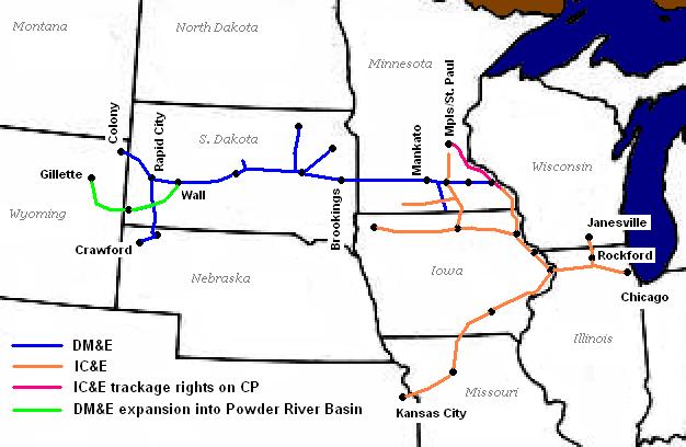
English: Route map of the Dakota and the Iowa as of 2002
State and lake outlines extracted from Perry-Castañeda Library Map Collection; the Library's FAQ asserts public domain status on the original map. Railroad outlines and city and state labels by Sean Lamb (User:Slambo), January 20 2005; created using Microsoft Paint, based on a map published in the May 2002 issue of Trains Magazine (p. 14). |
| Date | 21 January 2005 (original upload date) |
| Source | Transferred from en.wikipedia to Commons by Sreejithk2000 using CommonsHelper. |
| Author | Slambo at English Wikipedia |

|
This transport map image could be re-created using vector graphics as an SVG file. This has several advantages; see Commons:Media for cleanup for more information. If an SVG form of this image is available, please upload it and afterwards replace this template with
{{vector version available|new image name}}.
It is recommended to name the SVG file “DME and ICE route map.svg”—then the template Vector version available (or Vva) does not need the new image name parameter. |


Licensing
[edit]
| This work has been released into the public domain by its author, Slambo at English Wikipedia. This applies worldwide. In some countries this may not be legally possible; if so: Slambo grants anyone the right to use this work for any purpose, without any conditions, unless such conditions are required by law. |
Original upload log
[edit]
The original description page was here. All following user names refer to en.wikipedia.
- 2005-01-21 02:34 Slambo 626×408× (42355 bytes) Route map of the [[Dakota, Minnesota and Eastern Railroad]] and the [[Iowa, Chicago and Eastern Railroad]] as of [[2002]]
File history
Click on a date/time to view the file as it appeared at that time.
| Date/Time | Thumbnail | Dimensions | User | Comment | |
|---|---|---|---|---|---|
| current | 01:46, 3 June 2010 | | 626 × 408 (41 KB) | File Upload Bot (Magnus Manske) (talk | contribs) | {{BotMoveToCommons|en.wikipedia|year={{subst:CURRENTYEAR}}|month={{subst:CURRENTMONTHNAME}}|day={{subst:CURRENTDAY}}}} {{Information |Description={{en|Route map of the en:Dakota, Minnesota and Eastern Railroad and the [[:en:Iowa, Chicago and Easter |
You cannot overwrite this file.
File usage on Commons
There are no pages that use this file.
File usage on other wikis
The following other wikis use this file:
- Usage on de.wikipedia.org
- Usage on en.wikipedia.org