File:DFmex TERRITORIO 1862 2.svg
Jump to navigation
Jump to search

Size of this PNG preview of this SVG file: 599 × 600 pixels. Other resolutions: 240 × 240 pixels | 480 × 480 pixels | 767 × 768 pixels | 1,023 × 1,024 pixels | 2,046 × 2,048 pixels | 2,195 × 2,197 pixels.
Original file (SVG file, nominally 2,195 × 2,197 pixels, file size: 130 KB)
Captions
Captions
Add a one-line explanation of what this file represents
Summary
[edit]
| Description |
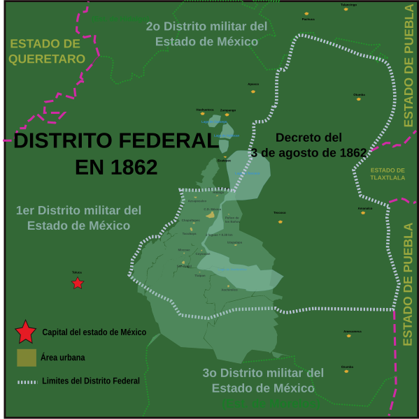
English: Extension of the Federal District by the decree of August 3, 1862 by President Benito Juárez, based on descriptions and http://mapserver.inegi.gob.mx/geografia/espanol/estados/edomex/imgs15/datoshis.pdf and Javier Romero Quiroz book, Territorial division and heraldry of the state of Mexico of 1977, published in Mexico by the state government of Mexico, no ISBN, pages 72 to 73.
Español: Extensión del Distrito Federal por el decreto del 3 de agosto de 1862 del presidente Benito Juárez, basado en las descripciones de http://mapserver.inegi.gob.mx/geografia/espanol/estados/edomex/imgs15/datoshis.pdf y del libro de Javier Romero Quiroz, División territorial y heráldica del estado de México del año 1977, publicado en México por el Gobierno del estado de México, sin ISBN, páginas de 72 a 73. |
| Source | Own work |
| Author | Sarumo74 |
Licensing
[edit]
I, the copyright holder of this work, hereby publish it under the following licenses:

|
Permission is granted to copy, distribute and/or modify this document under the terms of the GNU Free Documentation License, Version 1.2 or any later version published by the Free Software Foundation; with no Invariant Sections, no Front-Cover Texts, and no Back-Cover Texts. A copy of the license is included in the section entitled GNU Free Documentation License. |
This file is licensed under the Creative Commons Attribution 3.0 Unported license.
- You are free:
- to share – to copy, distribute and transmit the work
- to remix – to adapt the work
- Under the following conditions:
- attribution – You must give appropriate credit, provide a link to the license, and indicate if changes were made. You may do so in any reasonable manner, but not in any way that suggests the licensor endorses you or your use.
You may select the license of your choice.
File history
Click on a date/time to view the file as it appeared at that time.
| Date/Time | Thumbnail | Dimensions | User | Comment | |
|---|---|---|---|---|---|
| current | 21:25, 11 May 2011 | | 2,195 × 2,197 (130 KB) | Sarumo74 (talk | contribs) | Error en el área de impresión de archivo svg, mismas referencias. Error in the printing area svg file, the same references. |
| 21:22, 11 May 2011 |  | 544 × 549 (130 KB) | Sarumo74 (talk | contribs) | {{Information |Description ={{en|1=Extension of the Federal District by the decree of August 3, 1862 by President Benito Juárez, based on descriptions and http://mapserver.inegi.gob.mx/geografia/espanol/estados/edomex/imgs15/datoshis.pdf and Javier Ro |
You cannot overwrite this file.
File usage on Commons
There are no pages that use this file.
File usage on other wikis
The following other wikis use this file:
- Usage on es.wikipedia.org