File:DEU Ohligs COA.svg
Jump to navigation
Jump to search

Size of this PNG preview of this SVG file: 323 × 546 pixels. Other resolutions: 142 × 240 pixels | 284 × 480 pixels | 454 × 768 pixels | 606 × 1,024 pixels | 1,211 × 2,048 pixels.
Original file (SVG file, nominally 323 × 546 pixels, file size: 51 KB)
Captions
Captions
Add a one-line explanation of what this file represents
Summary
[edit]
| Description |
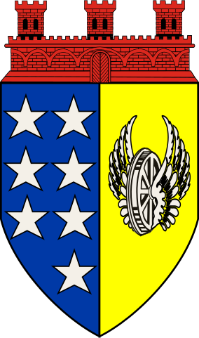
English: The municipality of Merscheid was founded in 1808, received city rights in 1856 and was renamed Ohligs in 1891.
Ohligs developed around the railway lines and a symbol for the railways should thus be included. The original design showed three fields, the winged wheel for the railway, the red lion of the Counts of Berg, who ruled the area for centuries, and some small stars, indicating that the city developed from many different villages and hamlets. In the final design the lion was removed and only the wheel and stars remained.
Deutsch: "Das Ohligser Stadtwappen zeigt im linken Feld einen senkrecht stehenden gespaltenen gotischen Schild mit sieben Silbersternen auf blauem Grund und rechts ein schwarzes Flügelrad auf goldenem Grund. Der obere Rand trägt eine dreitürmige Mauerkrone mit einem Tor in der Mitte, die Ohligs als Kleinstadt ausweist.“
Die Silbersterne repräsentieren die Vielzahl der Höfe, aus denen die Stadt hervorgegangen ist. Das Flügelrad symbolisiert Eisenbahn und Geschäftsverkehr. |
| Date | |
| Source | www.zeitspurensuche.de and www.ngw.nl |
| Author | Stadt Ohligs - constructed and added by Jürgen Krause |
Licensing
[edit]
This file depicts the coat of arms of a German Körperschaft des öffentlichen Rechts (corporation governed by public law). According to § 5 Abs. 1 of the German Copyright law, official works like coats of arms are in the public domain.
Note: The usage of coats of arms is governed by legal restrictions, independent of the copyright status of the depiction shown here.
|
 |
File history
Click on a date/time to view the file as it appeared at that time.
| Date/Time | Thumbnail | Dimensions | User | Comment | |
|---|---|---|---|---|---|
| current | 19:57, 1 September 2012 | | 323 × 546 (51 KB) | MaxxL (talk | contribs) | contour added |
| 19:52, 1 September 2012 |  | 323 × 546 (51 KB) | MaxxL (talk | contribs) | winged wheel redrawn | |
| 20:34, 30 August 2012 |  | 323 × 546 (37 KB) | Jürgen Krause (talk | contribs) | == {{int:filedesc}} == {{Information |Description={{en|1=The municipality of Merscheid was founded in 1808, received city rights in 1856 and was renamed Ohligs in 1891. Ohligs developed around the railway lines and a symbol for the railways should thus... |
You cannot overwrite this file.
File usage on Commons
The following page uses this file:
File usage on other wikis
The following other wikis use this file:
- Usage on de.wikipedia.org
- Ohligs
- Schloss Caspersbroich
- Eisenbahn in der Heraldik
- Dahl (Solingen)
- Garzenhaus
- Flügelrad (Eisenbahn)
- Loch (Solingen)
- Untenitter
- Vorlage:Navigationsleiste Hofschaften in der Stadt Merscheid/Ohligs
- Hübben
- Waardt
- Bavert
- Tiefendick
- Hülsen (Solingen)
- Riefnacken
- Aufderbech
- Altenufer
- Neuenufer
- Scharrenberg (Solingen)
- Engelsberg (Solingen)
- Heidufer
- Scheuer (Solingen)
- Maubes
- Dunkelnberg
- Obenmankhaus
- Poschheide
- Poschheider Mühle
- Hüttenhaus
- Rennpatt
- Schleifersberg
- Suppenheide
- Kullen (Ohligs)
- Deusberg
- Siebels (Solingen)
- Heipertz (Solingen)
- Pohligshof (Solingen)
- Schwarzenhäuschen
- Börkhaus
- Wiefeldick
- Auenberg (Solingen)
- Rosenkamp (Solingen)
- Capelle (Solingen)
- Pfaffenbusch (Solingen)
- Maubeshaus
- Trotzhilden
- Löhdorf
- Neu-Löhdorf
- Greuel (Solingen)
- Jammertal (Solingen)
- Straßen (Solingen)
View more global usage of this file.