File:DDZ Bridge over New Fork River.jpg
Jump to navigation
Jump to search

Size of this preview: 765 × 600 pixels. Other resolutions: 306 × 240 pixels | 612 × 480 pixels | 980 × 768 pixels | 1,280 × 1,004 pixels | 2,560 × 2,007 pixels | 4,656 × 3,651 pixels.
Original file (4,656 × 3,651 pixels, file size: 1.81 MB, MIME type: image/jpeg)
Captions
Captions
Add a one-line explanation of what this file represents
|
This is an image of a place or building that is listed on the National Register of Historic Places in the United States of America. Its reference number is 85000437. |
| Camera location | | View this and other nearby images on: OpenStreetMap |
|---|
| Description |
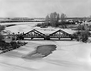
English: Southern side of the DDZ Bridge over New Fork River, which carries County Road 136 over the New Fork River near Boulder in Sublette County, Wyoming, United States. Built in 1917, it is the only two-span Kingpost timber truss bridge in the state, and it is listed on the National Register of Historic Places. |
||||
| Date | |||||
| Source |
Library of Congress, Prints and Photograph Division HAER: WYO,18-BOUL.V,1-3
|
||||
| Author | Clayton B. Fraser | ||||
| Permission (Reusing this file) |
|

File history
Click on a date/time to view the file as it appeared at that time.
| Date/Time | Thumbnail | Dimensions | User | Comment | |
|---|---|---|---|---|---|
| current | 16:11, 27 April 2009 | | 4,656 × 3,651 (1.81 MB) | Martin H. (talk | contribs) | High res; cropped |
| 15:18, 25 April 2009 |  | 1,024 × 820 (148 KB) | Nyttend (talk | contribs) | {{Location|42|45|2|N|109|43|33|W}} {{Information |Description={{en|Southern side of the {{w|DDZ Bridge over New Fork River}}, which carries County Road 136 over the {{w|New Fork River}} near {{w|Boulder, Wyoming|Boulder}} in {{w|Sublette County, Wyoming|S |
You cannot overwrite this file.
File usage on Commons
The following page uses this file:
File usage on other wikis
The following other wikis use this file:
- Usage on de.wikipedia.org
- Usage on en.wikipedia.org
- Usage on www.wikidata.org
- Usage on zh.wikipedia.org
Metadata
Categories:
- Built in Wyoming in 1917
- Bridges in the United States completed in 1917
- 1910s bridges in Wyoming
- 1982 in Wyoming
- Clayton B. Fraser
- National Register of Historic Places in Sublette County, Wyoming
- Bridges on the National Register of Historic Places in Wyoming
- Rivers of Wyoming
- Snow in Wyoming
- Through truss bridges in Wyoming