File:D16 Hohe Dubrau, Quarzitstruktur.JPG
Original file (2,070 × 1,163 pixels, file size: 2.23 MB, MIME type: image/jpeg)
Captions
Captions
Summary
[edit]DescriptionD16 Hohe Dubrau, Quarzitstruktur.JPG |
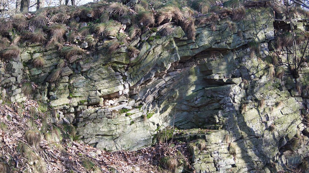
Deutsch: Quarzitstruktur mit Beulenrippen und Faltungsflächen. Beinhaltet Flachwasserfossilien. Entstehungszeit 450 Mio.Jahre im Ordovicium. Mächtigkeit der Lagen von 50 cm bis 150 m. |
Date | |
Source | Own work |
Author | PilzUlli |
Camera location | 51° 15′ 42.72″ N, 14° 41′ 13.07″ E ![]() | View this and other nearby images on: OpenStreetMap | ![]() |
---|
Licensing
[edit]![w:en:Creative Commons](https://upload.wikimedia.org/wikipedia/commons/thumb/7/79/CC_some_rights_reserved.svg/90px-CC_some_rights_reserved.svg.png)
![attribution](https://upload.wikimedia.org/wikipedia/commons/thumb/1/11/Cc-by_new_white.svg/24px-Cc-by_new_white.svg.png)
![share alike](https://upload.wikimedia.org/wikipedia/commons/thumb/d/df/Cc-sa_white.svg/24px-Cc-sa_white.svg.png)
- You are free:
- to share – to copy, distribute and transmit the work
- to remix – to adapt the work
- Under the following conditions:
- attribution – You must give appropriate credit, provide a link to the license, and indicate if changes were made. You may do so in any reasonable manner, but not in any way that suggests the licensor endorses you or your use.
- share alike – If you remix, transform, or build upon the material, you must distribute your contributions under the same or compatible license as the original.
![]() |
This image was uploaded as part of Wiki Loves Earth 2015.
aragonés | العربية | asturianu | azərbaycanca | беларуская (тарашкевіца) | български | বাংলা | brezhoneg | català | čeština | Cymraeg | Deutsch | Ελληνικά | English | español | eesti | euskara | فارسی | français | galego | עברית | hrvatski | հայերեն | Bahasa Indonesia | italiano | 日本語 | ქართული | 한국어 | latviešu | македонски | മലയാളം | मराठी | Bahasa Melayu | norsk bokmål | नेपाली | Nederlands | norsk | polski | português | português do Brasil | русский | sicilianu | shqip | slovenščina | српски / srpski | svenska | ไทย | Türkçe | українська | اردو | 中文 | 中文(台灣) | +/− |
![]() |
File history
Click on a date/time to view the file as it appeared at that time.
Date/Time | Thumbnail | Dimensions | User | Comment | |
---|---|---|---|---|---|
current | 07:22, 29 May 2015 | 2,070 × 1,163 (2.23 MB) | PilzUlli (talk | contribs) | User created page with UploadWizard |
You cannot overwrite this file.
File usage on Commons
The following page uses this file:
Metadata
This file contains additional information such as Exif metadata which may have been added by the digital camera, scanner, or software program used to create or digitize it. If the file has been modified from its original state, some details such as the timestamp may not fully reflect those of the original file. The timestamp is only as accurate as the clock in the camera, and it may be completely wrong.
Image title | SONY DSC |
---|---|
Camera manufacturer | SONY |
Camera model | SLT-A55V |
Exposure time | 1/60 sec (0.016666666666667) |
F-number | f/5 |
ISO speed rating | 100 |
Date and time of data generation | 15:06, 3 March 2012 |
Lens focal length | 35 mm |
Latitude | 51° 15′ 42.72″ N |
Longitude | 14° 41′ 13.07″ E |
Altitude | 146 meters above sea level |
Orientation | Normal |
Horizontal resolution | 350 dpi |
Vertical resolution | 350 dpi |
Software used | SLT-A55V v1.10 |
File change date and time | 15:06, 3 March 2012 |
Y and C positioning | Co-sited |
Exposure Program | Normal program |
Exif version | 2.3 |
Date and time of digitizing | 15:06, 3 March 2012 |
Meaning of each component |
|
Image compression mode | 2 |
APEX brightness | 5.37 |
APEX exposure bias | 0 |
Maximum land aperture | 4.64 APEX (f/4.99) |
Metering mode | Pattern |
Light source | Unknown |
Flash | Flash did not fire, auto mode |
Supported Flashpix version | 1 |
Color space | sRGB |
File source | Digital still camera |
Scene type | A directly photographed image |
Custom image processing | Normal process |
Exposure mode | Auto exposure |
White balance | Auto white balance |
Focal length in 35 mm film | 52 mm |
Scene capture type | Standard |
Contrast | Normal |
Saturation | Normal |
Sharpness | Normal |
GPS time (atomic clock) | 14:06 |
Receiver status | Measurement in progress |
Measurement mode | 3-dimensional measurement |
Speed unit | Kilometers per hour |
Speed of GPS receiver | 2.7 |
Reference for direction of movement | True direction |
Direction of movement | 198.61 |
Geodetic survey data used | WGS-84 |
GPS date | 3 March 2012 |
GPS differential correction | 0 |
GPS tag version | 0.0.3.2 |
Structured data
Items portrayed in this file
depicts
51°15'42.72502"N, 14°41'13.07400"E
3 March 2012
image/jpeg
88f2458d56d5f909c52d2fb13b97c0f0c3eed37a
2,342,654 byte
1,163 pixel
2,070 pixel
- Files with coordinates missing SDC location of creation
- CC-BY-SA-3.0
- Self-published work
- Images from Wiki Loves Earth 2015
- Images from Wiki Loves Earth 2015 in Germany
- Images from Wiki Loves Earth missing SDC depicts
- Images from Wiki Loves Earth missing SDC location of creation
- Images from Wiki Loves Earth 2015, DE-SN
- Uploaded via Campaign:wle-de-sn
- Germany photographs taken on 2012-03-03
- Pages with maps