File:D-6-78-157-3 Pfarrhaus Michelau im Steigerwald.jpg
Original file (4,360 × 3,330 pixels, file size: 4.32 MB, MIME type: image/jpeg)
Captions
Summary
[edit]DescriptionD-6-78-157-3 Pfarrhaus Michelau im Steigerwald.jpg |
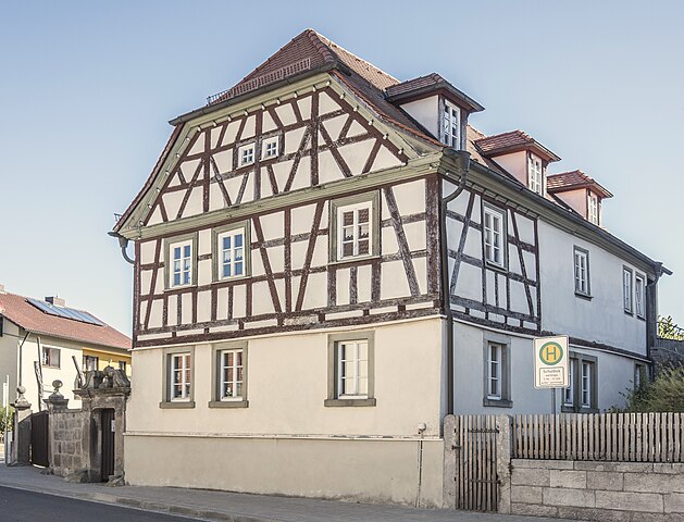
Deutsch: Altes Pfarrhaus, zweigeschossiger giebelständiger Halbwalmdachbau mit Fachwerkobergeschoss, 18. Jahrhundert; Hoftor mit Pforte, bezeichnet „1782“; vor der Einfahrt in Teilen erhaltenes historisches Ortspflaster This is a photograph of an architectural monument. It is on the list of cultural monuments of Bayern, no. D-6-78-157-3. |
Date | |
Source | Own work |
Author | Stephan van Helden |
Openstreetmap entry InfoField | Link to Openstreetmap |
Object location | 49° 54′ 27.69″ N, 10° 25′ 51.74″ E | View this and other nearby images on: OpenStreetMap | 49.907691; 10.431040 |
---|
Camera location | 49° 54′ 27.19″ N, 10° 25′ 50.45″ E | View this and other nearby images on: OpenStreetMap | 49.907552; 10.430680 |
---|
Licensing
[edit]- You are free:
- to share – to copy, distribute and transmit the work
- to remix – to adapt the work
- Under the following conditions:
- attribution – You must give appropriate credit, provide a link to the license, and indicate if changes were made. You may do so in any reasonable manner, but not in any way that suggests the licensor endorses you or your use.
- share alike – If you remix, transform, or build upon the material, you must distribute your contributions under the same or compatible license as the original.
This image was uploaded as part of Wiki Loves Monuments 2020.
Afrikaans ∙ Alemannisch ∙ العربية ∙ جازايرية ∙ azərbaycanca ∙ Bikol Central ∙ беларуская ∙ беларуская (тарашкевіца) ∙ български ∙ বাংলা ∙ brezhoneg ∙ bosanski ∙ català ∙ čeština ∙ Cymraeg ∙ dansk ∙ Deutsch ∙ Zazaki ∙ Ελληνικά ∙ English ∙ Esperanto ∙ español ∙ eesti ∙ euskara ∙ فارسی ∙ suomi ∙ français ∙ Frysk ∙ Gaeilge ∙ galego ∙ עברית ∙ हिन्दी ∙ hrvatski ∙ magyar ∙ հայերեն ∙ Bahasa Indonesia ∙ Ido ∙ italiano ∙ 日本語 ∙ ქართული ∙ 한국어 ∙ кыргызча ∙ Lëtzebuergesch ∙ latviešu ∙ Malagasy ∙ македонски ∙ മലയാളം ∙ Bahasa Melayu ∙ Malti ∙ norsk bokmål ∙ नेपाली ∙ Nederlands ∙ norsk nynorsk ∙ norsk ∙ polski ∙ português ∙ português do Brasil ∙ română ∙ русский ∙ sicilianu ∙ davvisámegiella ∙ slovenčina ∙ slovenščina ∙ shqip ∙ српски / srpski ∙ svenska ∙ ไทย ∙ Tagalog ∙ Türkçe ∙ українська ∙ اردو ∙ oʻzbekcha / ўзбекча ∙ Yorùbá ∙ 中文 ∙ 中文(中国大陆) ∙ 中文(简体) ∙ 中文(繁體) ∙ 中文(香港) ∙ 中文(臺灣) ∙ +/− |
This image has been assessed using the Quality image guidelines and is considered a Quality image.
العربية ∙ جازايرية ∙ беларуская ∙ беларуская (тарашкевіца) ∙ български ∙ বাংলা ∙ català ∙ čeština ∙ Cymraeg ∙ Deutsch ∙ Schweizer Hochdeutsch ∙ Zazaki ∙ Ελληνικά ∙ English ∙ Esperanto ∙ español ∙ eesti ∙ euskara ∙ فارسی ∙ suomi ∙ français ∙ galego ∙ עברית ∙ हिन्दी ∙ hrvatski ∙ magyar ∙ հայերեն ∙ Bahasa Indonesia ∙ italiano ∙ 日本語 ∙ Jawa ∙ ქართული ∙ 한국어 ∙ kurdî ∙ Lëtzebuergesch ∙ lietuvių ∙ македонски ∙ മലയാളം ∙ मराठी ∙ Bahasa Melayu ∙ Nederlands ∙ Norfuk / Pitkern ∙ polski ∙ português ∙ português do Brasil ∙ rumantsch ∙ română ∙ русский ∙ sicilianu ∙ slovenčina ∙ slovenščina ∙ shqip ∙ српски / srpski ∙ svenska ∙ தமிழ் ∙ తెలుగు ∙ ไทย ∙ Tagalog ∙ toki pona ∙ Türkçe ∙ українська ∙ vèneto ∙ Tiếng Việt ∙ 中文 ∙ 中文(简体) ∙ 中文(繁體) ∙ +/− |
File history
Click on a date/time to view the file as it appeared at that time.
Date/Time | Thumbnail | Dimensions | User | Comment | |
---|---|---|---|---|---|
current | 06:44, 8 December 2023 | 4,360 × 3,330 (4.32 MB) | Plozessor (talk | contribs) | Quality fixes (perspective, color, sharpness) | |
05:47, 15 October 2023 | 4,320 × 3,330 (4.27 MB) | Plozessor (talk | contribs) | Quality fixes (perspective, color, sharpness) | ||
06:24, 12 September 2020 | 4,320 × 3,330 (4.27 MB) | Plozessor (talk | contribs) | Uploaded own work with UploadWizard |
You cannot overwrite this file.
File usage on Commons
The following 7 pages use this file:
- User talk:Plozessor/Archive/2023-12
- Commons:Files used on OpenStreetMap/164
- Commons:Quality images/Subject/Architecture/Residential Buildings/Archive 2023
- Commons:Quality images candidates/Archives December 11 2023
- File:D-6-78-157-3 Pfarrhaus.jpg (file redirect)
- Category:Balthasar-Neumann-Straße 12 (Michelau im Steigerwald)
File usage on other wikis
The following other wikis use this file:
- Usage on de.wikipedia.org
- Usage on www.wikidata.org
Metadata
This file contains additional information such as Exif metadata which may have been added by the digital camera, scanner, or software program used to create or digitize it. If the file has been modified from its original state, some details such as the timestamp may not fully reflect those of the original file. The timestamp is only as accurate as the clock in the camera, and it may be completely wrong.
Camera manufacturer | FUJIFILM |
---|---|
Camera model | XF10 |
Exposure time | 1/1,000 sec (0.001) |
F-number | f/2.8 |
ISO speed rating | 200 |
Date and time of data generation | 10:50, 9 September 2020 |
Lens focal length | 18.5 mm |
Latitude | 49° 54′ 27.19″ N |
Longitude | 10° 25′ 50.45″ E |
Altitude | 289.935 meters above sea level |
City shown | Michelau im Steigerwald |
Width | 4,320 px |
Height | 3,330 px |
Bits per component |
|
Pixel composition | RGB |
Orientation | Normal |
Number of components | 3 |
Horizontal resolution | 300 dpi |
Vertical resolution | 300 dpi |
Software used | Adobe Photoshop CS6 (Windows) |
File change date and time | 07:43, 8 December 2023 |
Y and C positioning | Co-sited |
Exposure Program | Normal program |
Exif version | 2.3 |
Date and time of digitizing | 10:47, 9 September 2020 |
Meaning of each component |
|
Image compression mode | 3.2 |
APEX shutter speed | 9.965784 |
APEX aperture | 2.970854 |
APEX brightness | 7.1 |
APEX exposure bias | 0 |
Maximum land aperture | 2.97 APEX (f/2.8) |
Metering mode | Pattern |
Light source | Unknown |
Flash | Flash did not fire, compulsory flash suppression |
Supported Flashpix version | 1 |
Color space | Uncalibrated |
Focal plane X resolution | 2,553.2145996094 |
Focal plane Y resolution | 2,553.2145996094 |
Focal plane resolution unit | 3 |
Sensing method | One-chip color area sensor |
File source | Digital still camera |
Scene type | A directly photographed image |
Custom image processing | Normal process |
Exposure mode | Auto exposure |
White balance | Auto white balance |
Scene capture type | Standard |
Sharpness | Normal |
Subject distance range | Unknown |
GPS time (atomic clock) | 08:50 |
Geodetic survey data used | WGS-84 |
GPS date | 9 September 2020 |
GPS tag version | 0.0.2.2 |
Date metadata was last modified | 08:43, 8 December 2023 |
Rating (out of 5) | 0 |
Unique ID of original document | 909BE14BC343ED634A7D697DAEFA88B9 |
Code for country shown | DEU |
Sublocation of city shown | Michelau |
Country shown | Deutschland |
Province or state shown | Bayern |
IIM version | 1,023 |
Structured data
Items portrayed in this file
depicts
some value
49°54'27.187"N, 10°25'50.448"E
9 September 2020
0.001 second
2.8
18.5 millimetre
200
image/jpeg
90c0da09f892235150a2b7d989485f9e2264ca58
4,531,394 byte
3,330 pixel
4,360 pixel
49°54'27.6862"N, 10°25'51.7451"E
- On OSM
- Files with coordinates missing SDC location of creation (49° N, 10° E)
- CC-BY-SA-4.0
- Self-published work
- Images from Wiki Loves Monuments 2020
- Images from Wiki Loves Monuments 2020 in Germany
- Images from Wiki Loves Monuments missing SDC depicts
- Images from Wiki Loves Monuments missing SDC location of creation
- Images from Wiki Loves Monuments 2020, DE-BY
- Uploaded via Campaign:wlm-de-by
- Photos of cultural heritage monuments by Stephan van Helden
- Quality images from Wiki Loves Monuments 2020 in Germany
- Quality images by Stephan van Helden
- Quality images
- Quality images missing SDC depicts