File:D-6-74-180-58.jpg
Original file (3,000 × 4,000 pixels, file size: 4.58 MB, MIME type: image/jpeg)
Captions
Summary
[edit]DescriptionD-6-74-180-58.jpg |
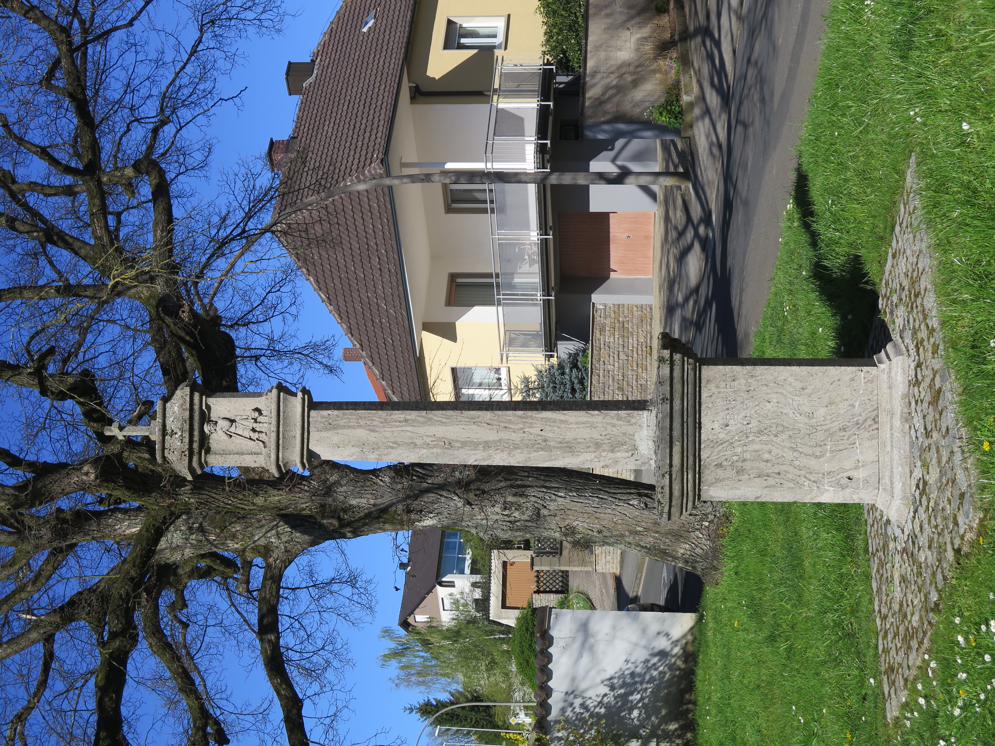
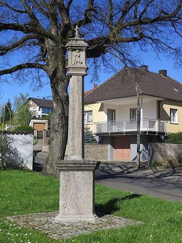
Deutsch: Bildstock, sechskantiger Pfeiler auf dreiseitigem Inschriftsockel, dreiseitiger reliefierter Aufsatz, Sandstein und Kalkstein, 1746/1946 This is a photograph of an architectural monument. It is on the list of cultural monuments of Bayern, no. D-6-74-180-58. |
Date | |
Source |
Own work This photo was taken with Canon PowerShot G16 |
Author | Stephan van Helden |
Camera location | 50° 01′ 07.16″ N, 10° 24′ 59.36″ E | View this and other nearby images on: OpenStreetMap | 50.018656; 10.416490 |
---|
Licensing
[edit]- You are free:
- to share – to copy, distribute and transmit the work
- to remix – to adapt the work
- Under the following conditions:
- attribution – You must give appropriate credit, provide a link to the license, and indicate if changes were made. You may do so in any reasonable manner, but not in any way that suggests the licensor endorses you or your use.
- share alike – If you remix, transform, or build upon the material, you must distribute your contributions under the same or compatible license as the original.
This image was uploaded as part of Wiki Loves Monuments 2016.
Afrikaans ∙ Alemannisch ∙ العربية ∙ جازايرية ∙ azərbaycanca ∙ Bikol Central ∙ беларуская ∙ беларуская (тарашкевіца) ∙ български ∙ বাংলা ∙ brezhoneg ∙ bosanski ∙ català ∙ čeština ∙ Cymraeg ∙ dansk ∙ Deutsch ∙ Zazaki ∙ Ελληνικά ∙ English ∙ Esperanto ∙ español ∙ eesti ∙ euskara ∙ فارسی ∙ suomi ∙ français ∙ Frysk ∙ Gaeilge ∙ galego ∙ עברית ∙ हिन्दी ∙ hrvatski ∙ magyar ∙ հայերեն ∙ Bahasa Indonesia ∙ Ido ∙ italiano ∙ 日本語 ∙ ქართული ∙ 한국어 ∙ кыргызча ∙ Lëtzebuergesch ∙ latviešu ∙ Malagasy ∙ македонски ∙ മലയാളം ∙ Bahasa Melayu ∙ Malti ∙ norsk bokmål ∙ नेपाली ∙ Nederlands ∙ norsk nynorsk ∙ norsk ∙ polski ∙ português ∙ português do Brasil ∙ română ∙ русский ∙ sicilianu ∙ davvisámegiella ∙ slovenčina ∙ slovenščina ∙ shqip ∙ српски / srpski ∙ svenska ∙ ไทย ∙ Tagalog ∙ Türkçe ∙ українська ∙ اردو ∙ oʻzbekcha / ўзбекча ∙ Yorùbá ∙ 中文 ∙ 中文(中国大陆) ∙ 中文(简体) ∙ 中文(繁體) ∙ 中文(香港) ∙ 中文(臺灣) ∙ +/− |
File history
Click on a date/time to view the file as it appeared at that time.
Date/Time | Thumbnail | Dimensions | User | Comment | |
---|---|---|---|---|---|
current | 06:42, 4 September 2016 | 3,000 × 4,000 (4.58 MB) | Plozessor (talk | contribs) | User created page with UploadWizard |
You cannot overwrite this file.
File usage on Commons
The following page uses this file:
File usage on other wikis
The following other wikis use this file:
- Usage on de.wikipedia.org
- Usage on www.wikidata.org
Metadata
This file contains additional information such as Exif metadata which may have been added by the digital camera, scanner, or software program used to create or digitize it. If the file has been modified from its original state, some details such as the timestamp may not fully reflect those of the original file. The timestamp is only as accurate as the clock in the camera, and it may be completely wrong.
Camera manufacturer | Canon |
---|---|
Camera model | Canon PowerShot G16 |
Author | Stephan van Helden |
Exposure time | 1/2,000 sec (0.0005) |
F-number | f/2.8 |
ISO speed rating | 100 |
Date and time of data generation | 16:24, 20 April 2016 |
Lens focal length | 10.52 mm |
Latitude | 50° 1′ 7.16″ N |
Longitude | 10° 24′ 59.37″ E |
Altitude | 224.801 meters above sea level |
City shown | Theres |
Orientation | Rotated 90° CCW |
Horizontal resolution | 180 dpi |
Vertical resolution | 180 dpi |
Software used | Microsoft Windows Photo Viewer 10.0.10586.0 |
File change date and time | 16:24, 20 April 2016 |
Y and C positioning | Co-sited |
Exif version | 2.3 |
Date and time of digitizing | 16:24, 20 April 2016 |
Meaning of each component |
|
Image compression mode | 3 |
APEX shutter speed | 10.96875 |
APEX aperture | 2.96875 |
APEX exposure bias | 0 |
Maximum land aperture | 2.28125 APEX (f/2.2) |
Metering mode | Pattern |
Flash | Flash did not fire, compulsory flash suppression |
Supported Flashpix version | 1 |
Color space | sRGB |
Focal plane X resolution | 13,745.704467354 |
Focal plane Y resolution | 13,698.630136986 |
Focal plane resolution unit | inches |
Sensing method | One-chip color area sensor |
File source | Digital still camera |
Custom image processing | Normal process |
Exposure mode | Auto exposure |
White balance | Auto white balance |
Digital zoom ratio | 1 |
Scene capture type | Standard |
GPS time (atomic clock) | 14:24 |
Geodetic survey data used | WGS-84 |
GPS date | 20 April 2016 |
GPS tag version | 2.2.0.0 |
Code for country shown | DEU |
Sublocation of city shown | Untertheres |
Country shown | Deutschland |
Province or state shown | Bayern |
IIM version | 4 |
Structured data
some value
20 April 2016
50°1'7.162"N, 10°24'59.364"E
image/jpeg
52add4f25eb30fac47e40dd261eb1875187d62fa
4,802,859 byte
4,000 pixel
3,000 pixel
- Taken with Canon PowerShot G16
- Files with coordinates missing SDC location of creation (50° N, 10° E)
- CC-BY-SA-4.0
- Self-published work
- Images from Wiki Loves Monuments 2016
- Images from Wiki Loves Monuments 2016 in Germany
- Images from Wiki Loves Monuments missing SDC location of creation
- Images from Wiki Loves Monuments 2016, DE-BY
- Uploaded via Campaign:wlm-de-by
- Photos of cultural heritage monuments by Stephan van Helden