File:Döbling (Wien) - Karl-Marx-Hof.JPG
Jump to navigation
Jump to search
Size of this preview: 800 × 566 pixels. Other resolutions: 320 × 226 pixels | 640 × 453 pixels | 1,024 × 724 pixels | 1,280 × 905 pixels | 2,560 × 1,810 pixels | 3,937 × 2,784 pixels.
Original file (3,937 × 2,784 pixels, file size: 9.17 MB, MIME type: image/jpeg)
Captions
Captions
Add a one-line explanation of what this file represents
Summary
[edit]| Description |
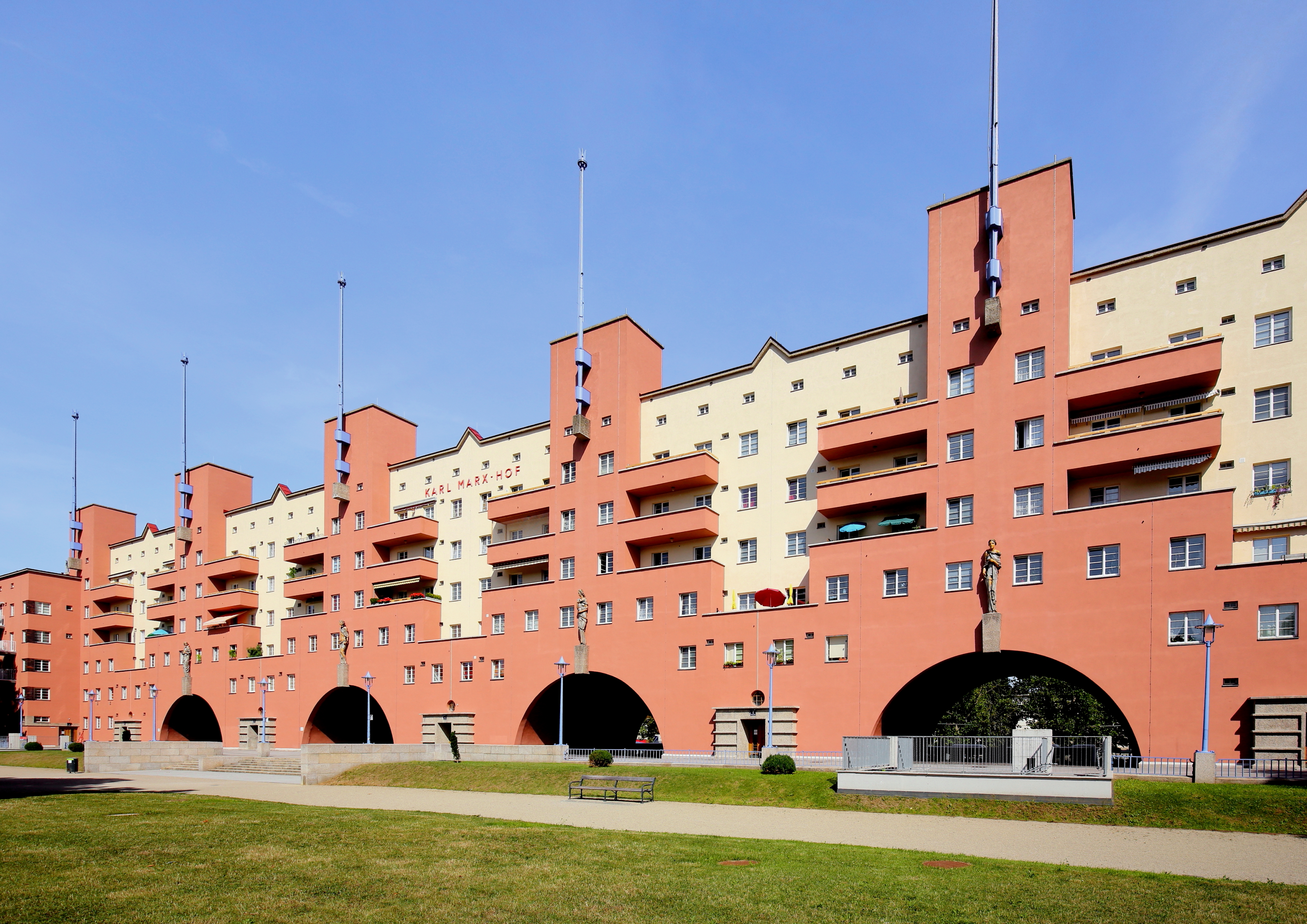
Deutsch: Der stark zurückversetzte Mitteltrakt mit seinen sechs monumentalen Türmen der denkmalgeschützten Wohnhausanlage Karl-Marx-Hof der Gemeinde Wien im 19. Wiener Gemeindebezirk Döbling.
Der Bau mit 1382 (aktuell rd. 1270) Wohneinheiten wurde von 1927 bis 1933 nach Plänen des Architekten Karl Ehn errichtet (die offizielle Eröffnung der Anlage fand am 12. Oktober 1930 statt). Er ist wohl der repräsentativste, sicherlich aber der bekannteste kommunale Wohnbau der Stadt Wien als Musterbeispiel eines monumentalen Superblocks. Er erstreckt sich über 1.100 Meter entlang der Heiligenstädter Straße und ist damit der längste zusammenhängende Wohnbau der Welt. Die vier Figuren über den Rundbögen sind Werke des Bildhauers Josef Franz Riedl (1884–1965) und symbolisieren die „Freiheit“, die „Fürsorge“, die „Aufklärung“ und die „Körperkultur“. |
| Date | |
| Source | Own work |
| Author | C.Stadler/Bwag |
| Permission (Reusing this file) |
Deutsch: Hallo, du darfst meine Fotos kostenlos nutzen, aber nenne mich bitte als Fotograf, beispielsweise „Foto: C.Stadler/Bwag“ oder © C.Stadler/Bwag; CC-BY-SA-4.0. Auf mehr Angaben bestehe ich nicht - im Gegensatz zu manch anderen, die die Vorgaben der unten angeführten Lizenzierung auf Punkt und Beistrich einfordern. English: Feel free to use my photos, but please mention me as the author like © C.Stadler/Bwag or © C.Stadler/Bwag; CC-BY-SA-4.0 (that's good enough) and if you want send me a message: bwag@gmx.net. |
| Other versions |
|
_-_Karl-Marx-Hof_(2).JPG)
_-_Karl-Marx-Hof.JPG&action=edit§ion=1)
| Object location | | View this and other nearby images on: OpenStreetMap |
|---|
_-_Karl-Marx-Hof.JPG¶ms=048.249353_N_0016.364310_E_globe:Earth_class:object_type:object__&language=en)
| Camera location | | View this and other nearby images on: OpenStreetMap |
|---|
_-_Karl-Marx-Hof.JPG¶ms=048.248998_N_0016.363621_E_globe:Earth_type:camera_heading:55.00&language=en)
Licensing
[edit]_-_Karl-Marx-Hof.JPG&action=edit§ion=2)
I, the copyright holder of this work, hereby publish it under the following license:
This file is licensed under the Creative Commons Attribution-Share Alike 4.0 International license.
- You are free:
- to share – to copy, distribute and transmit the work
- to remix – to adapt the work
- Under the following conditions:
- attribution – You must give appropriate credit, provide a link to the license, and indicate if changes were made. You may do so in any reasonable manner, but not in any way that suggests the licensor endorses you or your use.
- share alike – If you remix, transform, or build upon the material, you must distribute your contributions under the same or compatible license as the original.

|
This image was uploaded as part of Wiki Loves Monuments 2015.
|
File history
Click on a date/time to view the file as it appeared at that time.
| Date/Time | Thumbnail | Dimensions | User | Comment | |
|---|---|---|---|---|---|
| current | 20:17, 6 September 2017 | | 3,937 × 2,784 (9.17 MB) | Bwag (talk | contribs) | b |
| 16:42, 24 April 2017 |  | 3,937 × 2,784 (9.18 MB) | Bwag (talk | contribs) | wb | |
| 16:38, 1 September 2015 |  | 3,937 × 2,784 (9.03 MB) | Bwag (talk | contribs) | {{Information |Description= {{de|1=Der stark zurückversetzte Mitteltrakt mit seinen sechs monumentalen Türmen der denkmalgeschützte Wohnhausanlagen ''Karl-Marx-Hof'' der Gemeinde Wien im 19. Wiener Gemeindebezirk... |
You cannot overwrite this file.
File usage on Commons
The following 5 pages use this file:
File usage on other wikis
The following other wikis use this file:
- Usage on af.wikipedia.org
- Usage on arz.wikipedia.org
- Usage on be.wikipedia.org
- Usage on cs.wikipedia.org
- Usage on da.wikipedia.org
- Usage on de.wikipedia.org
- Karl Marx
- 12. Oktober
- Geschichte Wiens
- Karl-Marx-Hof
- Heiligenstadt (Wien)
- Diskussion:Karl-Marx-Hof
- Liste technischer Rekorde
- Karl Ehn
- Liste der Wiener Gemeindebauten
- Liste der denkmalgeschützten Objekte in Wien/Döbling/Grinzing–Neustift am Wald
- Liste der Wiener Gemeindebauten/Innere Stadt
- Vorlage:Navigationsleiste Wiener Gemeindebauten
- Liste der Wiener Gemeindebauten/Leopoldstadt
- Liste der Wiener Gemeindebauten/Landstraße
- Liste der Wiener Gemeindebauten/Wieden
- Liste der Wiener Gemeindebauten/Margareten
- Liste der Wiener Gemeindebauten/Mariahilf
- Liste der Wiener Gemeindebauten/Neubau
- Liste der Wiener Gemeindebauten/Josefstadt
- Liste der Wiener Gemeindebauten/Alsergrund
- Liste der Wiener Gemeindebauten/Brigittenau
- Liste der Wiener Gemeindebauten/Penzing
- Liste der Wiener Gemeindebauten/Döbling
- Liste der Wiener Gemeindebauten/Liesing
- Liste der Wiener Gemeindebauten/Simmering
- Liste der Wiener Gemeindebauten/Floridsdorf
- Liste der Wiener Gemeindebauten/Donaustadt
- Liste der Wiener Gemeindebauten/Währing
- Liste der Wiener Gemeindebauten/Hernals
- Liste der Wiener Gemeindebauten/Ottakring
- Liste der Wiener Gemeindebauten/Rudolfsheim-Fünfhaus
- Liste der Wiener Gemeindebauten/Hietzing
- Liste der Wiener Gemeindebauten/Meidling
- Liste der Wiener Gemeindebauten/Favoriten
- Wikipedia:Wiki Loves Monuments Österreich/Tagdesdenkmals 2016/Wien
- Benutzer:Carl Ha/AAA
- Emil Swoboda
- Portal:Österreich/RegiowikiAT Redundanzen
- Wikipedia:WikiProjekt Österreich/WD/Döbling
- Wikipedia:WikiProjekt Österreich/checks/Wiener Gemeindebauten/WP - WD diffs 01
- Usage on de.wikivoyage.org
- Usage on el.wikipedia.org
- Usage on en.wikipedia.org
View more global usage of this file.
_-_Karl-Marx-Hof.JPG)
_-_Karl-Marx-Hof.JPG&oldid=781868920)