File:Cyprus districts mk.svg
Jump to navigation
Jump to search

Size of this PNG preview of this SVG file: 800 × 487 pixels. Other resolutions: 320 × 195 pixels | 640 × 389 pixels | 1,024 × 623 pixels | 1,280 × 779 pixels | 2,560 × 1,558 pixels | 1,060 × 645 pixels.
Original file (SVG file, nominally 1,060 × 645 pixels, file size: 188 KB)
Captions
Captions
Add a one-line explanation of what this file represents
Summary
[edit]| Description |
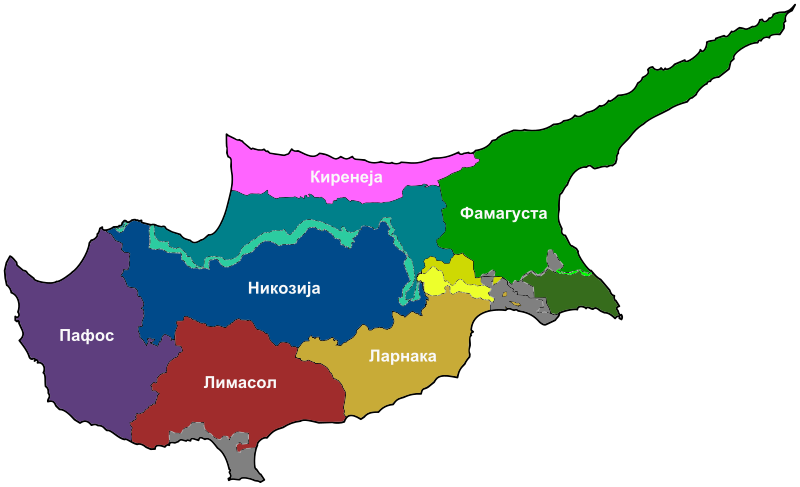
Македонски: Карта на окрузите во Кипар.
English: Map in Macedonian showing the districts of Cyprus. |
| Date | (UTC) |
| Source |
This file was derived from: Cyprus districts.svg: |
| Author |
|
| Other versions |
[]
|


| This is a retouched picture, which means that it has been digitally altered from its original version. Modifications: Translated to Macedonian. The original can be viewed here: Cyprus districts.svg:
|
Licensing
[edit]
I, the copyright holder of this work, hereby publish it under the following license:
This file is licensed under the Creative Commons Attribution 3.0 Unported license.
- You are free:
- to share – to copy, distribute and transmit the work
- to remix – to adapt the work
- Under the following conditions:
- attribution – You must give appropriate credit, provide a link to the license, and indicate if changes were made. You may do so in any reasonable manner, but not in any way that suggests the licensor endorses you or your use.
Original upload log
[edit]
This image is a derivative work of the following images:
- File:Cyprus_districts.svg licensed with Cc-by-3.0
- 2011-03-30T18:21:45Z Ufo karadagli 1060x645 (154135 Bytes) British bases colored gray, color of [[w:Kokkina exclave|]] corrected and code cleaned up.
- 2011-03-20T16:17:57Z Chipmunkdavis 1060x645 (161691 Bytes) Standardising the difference between the north and south, making the south darker, while highlighting the UN buffer zone. Blanking Akrotiri and Dhekelia.
- 2011-03-12T11:36:35Z Ufo karadagli 1060x645 (160637 Bytes) {{Information |Description={{en|1=Map of Cyprus showing districts}} |Source=*[[:File:Cyprus_districts.jpg|]] |Date=2011-03-12 11:00 (UTC) |Author=*[[:File:Cyprus_districts.jpg|]]: [[User:NeoCy|Alexander-Michael Hadjilyra]] *d
Uploaded with derivativeFX
File history
Click on a date/time to view the file as it appeared at that time.
| Date/Time | Thumbnail | Dimensions | User | Comment | |
|---|---|---|---|---|---|
| current | 01:36, 14 March 2013 | | 1,060 × 645 (188 KB) | Bjankuloski06en (talk | contribs) | == {{int:filedesc}} == {{Information |Description={{mk|1=Карта на окрузите во Кипар.}} {{en|1=Map in Macedonian showing the districts of Cyprus.}} |Source={{Derived from|Cyprus_districts.svg|di... |
You cannot overwrite this file.
File usage on Commons
The following 4 pages use this file:
File usage on other wikis
The following other wikis use this file:
- Usage on mk.wikipedia.org