File:Cyprus - Envisat.jpg
Jump to navigation
Jump to search

Size of this preview: 563 × 600 pixels. Other resolutions: 225 × 240 pixels | 451 × 480 pixels | 721 × 768 pixels | 961 × 1,024 pixels | 1,923 × 2,048 pixels | 3,000 × 3,195 pixels.
Original file (3,000 × 3,195 pixels, file size: 8.43 MB, MIME type: image/jpeg)
Captions
Captions
Add a one-line explanation of what this file represents
Summary
[edit]| Cyprus | |
|---|---|
| Photographer |
Envisat satellite |
| Title |
Cyprus |
| Description |
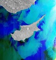
English: Covering part of the Eastern Mediterranean this Envisat image is dominated by the island of Cyprus. The capital and largest city, Nicosia, is located near the centre of the image. Around Nicosia we see a concentration of white specks. This is the typical appearance of built-up areas in radar images, since the radar beam is reflected by buildings and other constructions. Similar concentrations are seen south east of Nicosia, where the seafront city of Larnaca lies, and further west along the coast to Limassol, the island’s second largest city.
This image is a compilation of three images from Envisat’s radar, acquired on 27 September, 27 October and 26 November 2011. |
| Depicted place | Cyprus |
| Date | between 27 September 2011 and 26 November 2011 |
| Collection | European Space Agency |
| Accession number |
279938 |
| Credit line | ESA |
| Source | http://www.esa.int/spaceinimages/Images/2012/10/Cyprus |
| Other versions |
|
Licensing
[edit]
This file is licensed under the Creative Commons Attribution-ShareAlike 3.0 IGO license.
Attribution: ESA
- You are free:
- to share – to copy, distribute and transmit the work
- to remix – to adapt the work
- Under the following conditions:
- attribution – You must give appropriate credit, provide a link to the license, and indicate if changes were made. You may do so in any reasonable manner, but not in any way that suggests the licensor endorses you or your use.
- share alike – If you remix, transform, or build upon the material, you must distribute your contributions under the same or compatible license as the original.
File history
Click on a date/time to view the file as it appeared at that time.
| Date/Time | Thumbnail | Dimensions | User | Comment | |
|---|---|---|---|---|---|
| current | 08:33, 22 February 2017 | | 3,000 × 3,195 (8.43 MB) | Revent (talk | contribs) | =={{int:filedesc}}== {{Photograph |photographer = Envisat satellite |title = Cyprus |description = {{en|Covering part of the Eastern Mediterranean this Envisat image is dominated by the island of Cyprus. The capital and lar... |
You cannot overwrite this file.
File usage on Commons
The following 4 pages use this file: