File:Cyprus. LOC 2010588613.jpg
Jump to navigation
Jump to search

Size of this preview: 766 × 599 pixels. Other resolutions: 307 × 240 pixels | 613 × 480 pixels | 981 × 768 pixels | 1,280 × 1,002 pixels | 2,560 × 2,003 pixels | 4,324 × 3,384 pixels.
Original file (4,324 × 3,384 pixels, file size: 1.51 MB, MIME type: image/jpeg)
Captions
Captions
Add a one-line explanation of what this file represents
Summary
[edit]| Description |
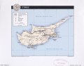
English: General-content map also showing "United Nations buffer zone" and U.K. sovereign areas. "803203AI (G00532) 7-10." Available also through the Library of Congress Web site as a raster image. Includes location map (inset). |
||
| Title | Cyprus. | ||
| Shelf ID | G7450 2010 .U5 | ||
| Date | |||
| Source | https://www.loc.gov/item/2010588613/ | ||
| Author | United States. Central Intelligence Agency | ||
| Permission (Reusing this file) |
|
||
| Other versions |
|
||
| Location | Cyprus | ||
| Part of | American Memory · General Maps · Catalog · Geography And Map Division | ||
| Subject | Maps · Cyprus |

Licensing
[edit]
| This image is a work of a Central Intelligence Agency employee, taken or made as part of that person's official duties. As a Work of the United States Government, this image or media is in the public domain in the United States.
|

|
File history
Click on a date/time to view the file as it appeared at that time.
| Date/Time | Thumbnail | Dimensions | User | Comment | |
|---|---|---|---|---|---|
| current | 13:35, 8 June 2018 | | 4,324 × 3,384 (1.51 MB) | Fæ (talk | contribs) | LOC Maps https://www.loc.gov/item/2010588613/ #8734 |
You cannot overwrite this file.
File usage on Commons
The following page uses this file: