File:Cyclone Gonu TRMM Image (2007).jpg

Original file (1,024 × 1,024 pixels, file size: 793 KB, MIME type: image/jpeg)
Captions
Captions
Summary
[edit]| DescriptionCyclone Gonu TRMM Image (2007).jpg |
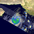
At one time, Cyclone Gonu was a powerful Category 5 storm packing sustained winds of 255 km/h (160 miles/h), according to the Joint Typhoon Warning Center, and on a course towards Oman. This made it the most powerful cyclone ever to threaten the Arabian Peninsula since record keeping began back in 1945. Tropical cyclones do on occasion form in the Arabian Sea, but they rarely exceed tropical storm intensity. In 2006, Tropical Storm Mukda was the only system to form in the region, and it remained well out to sea before dissipating. Gonu became a tropical storm in the morning (local time) of June 2, 2007, in the east-central Arabian Sea. After some initial fluctuations in direction, the storm settled on a northwesterly track and began to intensify. Gonu went from tropical storm intensity to a Category 2 Tropical Cyclone on the night of June 3. Overnight, it developed into a Category 4 storm with winds estimated at 210 km/h (132 mph). The Tropical Rainfall Measuring Mission (TRMM) captured this image of Gonu as the storm was moving northwest over the central Arabian Sea. The image was taken at 6:23 a.m. local time (03:23 UTC) on June 4, 2007, when Gonu was a Category 4 storm. It shows the horizontal distribution of rain intensity looking down on the storm. The distribution of rain within the storm reveals the storm’s structure, and in this case, Gonu displays all of the tell-tale signs of a potent storm. Not only did Gonu have a complete, well-formed, symmetrical eye surrounded by an intense eyewall (innermost red ring), this inner eyewall was surrounded by a concentric outer eyewall (outermost red and green ring). This double eyewall structure only occurs in very intense storms. Eventually the outer eyewall will contract and replace the inner eyewall, a process known as eyewall replacement. The image was made with data from several sensors on the TRMM satellite. Rain rates in the center of the swath are from the TRMM Precipitation Radar, while those in the outer portion are from the TRMM Microwave Imager. The rain rates are overlaid on infrared data from the TRMM Visible Infrared Scanner. Several hours after this image was taken, Gonu reached Category 5 intensity, the very peak of possible storm strengths. The system remained in this high state through the day, then began weakening during the night of June 4 as it continued to approach the coast of Oman. The center remained just offshore of the northeast coast of Oman as a Category 1 storm before turning northward towards Iran, where it was expected to make landfall as a tropical storm, according to forecasts made on June 6, 2007. The TRMM satellite was placed into service in November 1997. From its low-earth orbit, TRMM provides valuable images and information on storm systems around the tropics using a combination of passive microwave and active radar sensors, including the first precipitation radar in space. TRMM is a joint mission between NASA and the Japanese space agency, JAXA. |
||||||
| Date | |||||||
| Source | http://earthobservatory.nasa.gov/NaturalHazards/Archive/Jun2007/gonu_trmm_2007155_lrg.jpg | ||||||
| Author | Images produced by Hal Pierce (SSAI/NASA GSFC) and caption by Steve Lang (SSAI/NASA GSFC). | ||||||
| Permission (Reusing this file) |
|
File history
Click on a date/time to view the file as it appeared at that time.
| Date/Time | Thumbnail | Dimensions | User | Comment | |
|---|---|---|---|---|---|
| current | 22:57, 9 June 2007 |  | 1,024 × 1,024 (793 KB) | A7x (talk | contribs) | At one time, Cyclone Gonu was a powerful Category 5 storm packing sustained winds of 255 kilometers per hour (160 miles per hour), according to the Joint Typhoon Warning Center, and on a course towards Oman. This made it the most powerful cyclone ever to |
You cannot overwrite this file.
File usage on Commons
There are no pages that use this file.
Metadata
This file contains additional information such as Exif metadata which may have been added by the digital camera, scanner, or software program used to create or digitize it. If the file has been modified from its original state, some details such as the timestamp may not fully reflect those of the original file. The timestamp is only as accurate as the clock in the camera, and it may be completely wrong.
| Width | 1,024 px |
|---|---|
| Height | 1,024 px |
| Compression scheme | Uncompressed |
| Pixel composition | RGB |
| Orientation | Normal |
| Number of components | 3 |
| Horizontal resolution | 72 dpi |
| Vertical resolution | 72 dpi |
| Data arrangement | chunky format |
| Software used | Adobe Photoshop CS2 Macintosh |
| File change date and time | 10:44, 7 June 2007 |
| Color space | Uncalibrated |

