File:Cut Map of the Hala'ib triangle.jpg
Jump to navigation
Jump to search

Size of this preview: 800 × 353 pixels. Other resolutions: 320 × 141 pixels | 640 × 283 pixels | 1,024 × 452 pixels | 1,280 × 565 pixels | 2,560 × 1,130 pixels | 8,567 × 3,782 pixels.
Original file (8,567 × 3,782 pixels, file size: 21.78 MB, MIME type: image/jpeg)
Captions
Captions
Add a one-line explanation of what this file represents
| Description |
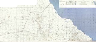
Deutsch: Karte des Hala’ib-Dreiecks English: Map of the Hala'ib triangle |
| Date | Original:1954 Edited:2010-06-19 17:01 (UTC) |
| Source | |
| Author |
|
| This is a retouched picture, which means that it has been digitally altered from its original version. Modifications: cut to smaller size, legend elements pasted to top right. The original can be viewed here: Map of the Hala'ib triangle.jpg:
|
This file is a work of a U.S. Army soldier or employee, taken or made as part of that person's official duties. As a work of the U.S. federal government, it is in the public domain in the United States.
|
 |
Original upload log
[edit]
This image is a derivative work of the following images:
- File:Map_of_the_Hala'ib_triangle.jpg licensed with PD-USGov-Military-Army
- 2010-06-17T20:47:01Z Chumwa 12962x6841 (17578828 Bytes) {{Information |Description= {{de|Karte des Hala’ib-Dreiecks}} {{en|Map of the Hala'ib triangle}} |Source=The following map sheets of the North Africa 1:250,000 Series P502 by the U.S. Army Map Service: * [[:Image:Txu-oclc-
Uploaded with derivativeFX
File history
Click on a date/time to view the file as it appeared at that time.
| Date/Time | Thumbnail | Dimensions | User | Comment | |
|---|---|---|---|---|---|
| current | 17:09, 19 June 2010 | | 8,567 × 3,782 (21.78 MB) | Ratzer (talk | contribs) | {{Information |Description={{de|Karte des Hala’ib-Dreiecks}} {{en|Map of the Hala'ib triangle}} |Source=*File:Map_of_the_Hala'ib_triangle.jpg |Date=2010-06-19 17:01 (UTC) |Author=*File:Map_of_the_Hala'ib_triangle.jpg: [[:de:User:Chumwa|Maxim |
You cannot overwrite this file.
File usage on Commons
There are no pages that use this file.
File usage on other wikis
The following other wikis use this file:
- Usage on ar.wikipedia.org
- Usage on az.wikipedia.org
- Usage on ca.wikipedia.org
- Usage on de.wikipedia.org
- Usage on en.wikipedia.org
- Usage on es.wikipedia.org
- Usage on fi.wikipedia.org
- Usage on fr.wikipedia.org
- Usage on he.wikipedia.org
- Usage on it.wikipedia.org
- Usage on ja.wikipedia.org
- Usage on nl.wikipedia.org
- Usage on no.wikipedia.org
- Usage on ru.wikipedia.org
- Usage on so.wikipedia.org
- Usage on sr.wikipedia.org
- Usage on uk.wikipedia.org
- Usage on zh.wikipedia.org