File:Custer Battlefield marked on the 1851 De Smet map of the Indian territories as defined in the Fort Laramie treaty (1851).png
Jump to navigation
Jump to search

Size of this preview: 800 × 536 pixels. Other resolutions: 320 × 214 pixels | 640 × 429 pixels | 1,024 × 686 pixels | 1,280 × 857 pixels | 2,560 × 1,714 pixels | 4,255 × 2,849 pixels.
Original file (4,255 × 2,849 pixels, file size: 15.64 MB, MIME type: image/png)
Captions
Captions
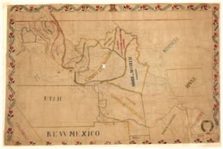
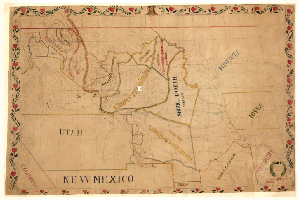
Father De Smets 1851 map of the native territories as put down in the Fort Laramie treaty (1851). The white X marks the Custer Battlefield at the Little Bighorn River (1876) in treaty defined territory of the Crow
Summary
[edit].png&action=edit§ion=1)
| Description |
Dansk: De Smets forvrængede kort over de forskellige præriestammers territorier som fastlagt i 1851 med Fort Laramie traktaten. Custer slaget ved Little Bighorn River i 1876 mellem lakotaer og den amerikanske hær er markeret med hvidt. Kampen fandt sted i hjertet af et område anerkendt af lakotaerne som deres fjender i crow-stammens territorium i 1851
English: De Smets twisted map of the territories of the plains tribes as agreed upon in the Fort Laramie treaty (1851). The white X marks the Custer Battlefield at the Little Bighorn River (1876) between the Lakotas and the U.S. Army in the heart of a territory recognized by the Lakota as the land of their enemies in the Crow Nation in 1851 |
| Date | |
| Source | Library of Congress. hdl.loc.gov/loc.gmd/g4050.ct000883. “Map of the Upper Great Plains and Rocky Mountains region.” (The map is adapted to show the Custer Battlefield in Crow treaty defined territory (Fort Laramie Treaty 1851)) |
| Author | Father De Smet (1801-1873). |
Licensing
[edit].png&action=edit§ion=2)
This work is in the public domain in the United States because it was published (or registered with the U.S. Copyright Office) before January 1, 1929.
Public domain works must be out of copyright in both the United States and in the source country of the work in order to be hosted on the Commons. If the work is not a U.S. work, the file must have an additional copyright tag indicating the copyright status in the source country.
Note: This tag should not be used for sound recordings. |

|
This is a file uploaded through the Danish Wikipedia, which has not been reviewed on Commons:
|
File history
Click on a date/time to view the file as it appeared at that time.
| Date/Time | Thumbnail | Dimensions | User | Comment | |
|---|---|---|---|---|---|
| current | 09:07, 18 September 2022 | | 4,255 × 2,849 (15.64 MB) | Indianertosset (talk | contribs) | Uploaded a work by Father De Smet (1801-1873). from Library of Congress. hdl.loc.gov/loc.gmd/g4050.ct000883. “Map of the Upper Great Plains and Rocky Mountains region.” (The map is adapted to show the Custer Battlefield in Crow treaty defined territory (Fort Laramie Treaty 1851)) with UploadWizard |
You cannot overwrite this file.
File usage on Commons
There are no pages that use this file.
File usage on other wikis
The following other wikis use this file:
- Usage on da.wikipedia.org
.png&oldid=876389131)