File:Curtis Bay Depot D3C1219-300947A001.jpg
Jump to navigation
Jump to search

Size of this preview: 800 × 483 pixels. Other resolutions: 320 × 193 pixels | 640 × 387 pixels | 1,024 × 619 pixels | 1,280 × 773 pixels | 2,264 × 1,368 pixels.
Original file (2,264 × 1,368 pixels, file size: 756 KB, MIME type: image/jpeg)
Captions
Captions
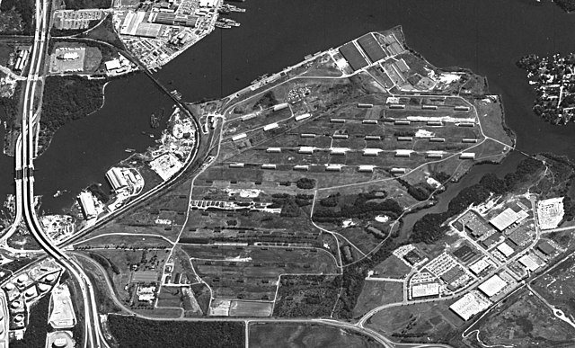
Curtis Bay Depot in 1984
Summary
[edit]
| Description |
English: Oblique view of Curtis Bay Depot, Defense Logistics Agency site, in 1984. Ordnance Road is along the bottom, and north is to the left. The highway along the left edge is I-695, the Baltimore Beltway. The channel in upper left is Curtis Creek, and the stream at right is Back Creek. Many of the buildings adjacent to Ordnance Road have been demolished to create a sports park with multiple baseball fields. Most other buildings on the site are in disrepair and are collapsing (as of 2021), but some close to the riverfront are still in use. |
| Date | |
| Source | EarthExplorer, USGS. Declassified panoramic camera image. |
| Author | NASA/USGS |
Licensing
[edit]
This work is in the public domain in the United States because it is a work prepared by an officer or employee of the United States Government as part of that person’s official duties under the terms of Title 17, Chapter 1, Section 105 of the US Code.
Note: This only applies to original works of the Federal Government and not to the work of any individual U.S. state, territory, commonwealth, county, municipality, or any other subdivision. This template also does not apply to postage stamp designs published by the United States Postal Service since 1978. (See § 313.6(C)(1) of Compendium of U.S. Copyright Office Practices). It also does not apply to certain US coins; see The US Mint Terms of Use.
|
 | |
| This file has been identified as being free of known restrictions under copyright law, including all related and neighboring rights. | ||
File history
Click on a date/time to view the file as it appeared at that time.
| Date/Time | Thumbnail | Dimensions | User | Comment | |
|---|---|---|---|---|---|
| current | 02:28, 25 February 2021 | | 2,264 × 1,368 (756 KB) | Jstuby (talk | contribs) | Uploaded a work by NASA/USGS from [https://earthexplorer.usgs.gov/ EarthExplorer], USGS. Declassified panoramic camera image. with UploadWizard |
You cannot overwrite this file.
File usage on Commons
There are no pages that use this file.
File usage on other wikis
The following other wikis use this file:
- Usage on en.wikipedia.org
- Usage on www.wikidata.org