File:Current US military deployments.png
Jump to navigation
Jump to search
No higher resolution available.
Current_US_military_deployments.png (800 × 353 pixels, file size: 42 KB, MIME type: image/png)
Captions
Captions
Add a one-line explanation of what this file represents

|
This military map image could be re-created using vector graphics as an SVG file. This has several advantages; see Commons:Media for cleanup for more information. If an SVG form of this image is available, please upload it and afterwards replace this template with
{{vector version available|new image name}}.
It is recommended to name the SVG file “Current US military deployments.svg”—then the template Vector version available (or Vva) does not need the new image name parameter. |
Summary
[edit]
| Description |
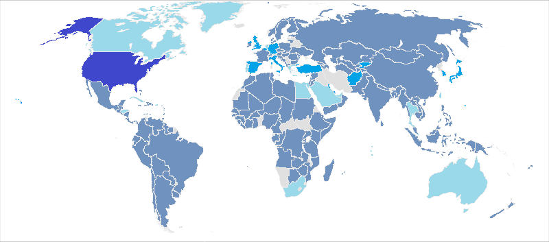
English: This map, using information from the Defense Manpower Data Center is an update of a map previously used for the webpage, United States military deployments by Lokal_Profil with information from 2007. This map has those listed as part of Overseas Contingency Operation Deployments integrated in, while military dependents and civilian personnel are omitted. Legend:
No US military men
Less than a hundred US military men
More than a hundred military men
More than 1,000 military men
United States
For the map itself, most of those deployments that are less than 100 troops are usually less than fifty military personnel, just for public knowledge. |
| Date | |
| Source |
|
| Author | Wikiedebs |
| Permission (Reusing this file) |
I, the copyright holder of this work, hereby publish it under the following license: This file is licensed under the Creative Commons Attribution-Share Alike 2.5 Generic license.
|
File history
Click on a date/time to view the file as it appeared at that time.
| Date/Time | Thumbnail | Dimensions | User | Comment | |
|---|---|---|---|---|---|
| current | 03:13, 9 March 2016 | | 800 × 353 (42 KB) | Mahogany115 (talk | contribs) | Reverted to version as of 03:11, 9 March 2016 (UTC) |
| 03:12, 9 March 2016 |  | 800 × 353 (57 KB) | Mahogany115 (talk | contribs) | marked the location of united states | |
| 03:11, 9 March 2016 |  | 800 × 353 (42 KB) | Mahogany115 (talk | contribs) | marked united states | |
| 13:35, 15 April 2015 |  | 800 × 353 (63 KB) | Prinsgezinde (talk | contribs) | Made a new file instead of updating this one | |
| 08:38, 15 April 2015 |  | 4,500 × 2,234 (208 KB) | Prinsgezinde (talk | contribs) | Own variation based on previous version. Original picture was of a resolution too low to be very helpful. The colors it used to portray the presence were also somewhat confusing, not clearly indicating a pattern in intensity. I took a larger world map... | |
| 23:31, 16 November 2014 |  | 800 × 353 (63 KB) | Zhitelew (talk | contribs) | clean up | |
| 22:28, 9 December 2013 |  | 800 × 353 (55 KB) | Wikiedebs (talk | contribs) | User created page with UploadWizard |
You cannot overwrite this file.
File usage on Commons
There are no pages that use this file.
File usage on other wikis
The following other wikis use this file:
- Usage on ar.wikipedia.org
- Usage on ro.wikipedia.org
- Usage on zh.wikipedia.org
- Usage on zh.wikinews.org