File:Cup and ring marks.jpg
Jump to navigation
Jump to search
Size of this preview: 450 × 600 pixels. Other resolutions: 180 × 240 pixels | 600 × 800 pixels.
Original file (600 × 800 pixels, file size: 125 KB, MIME type: image/jpeg)
Captions
Captions
Add a one-line explanation of what this file represents
| Description |
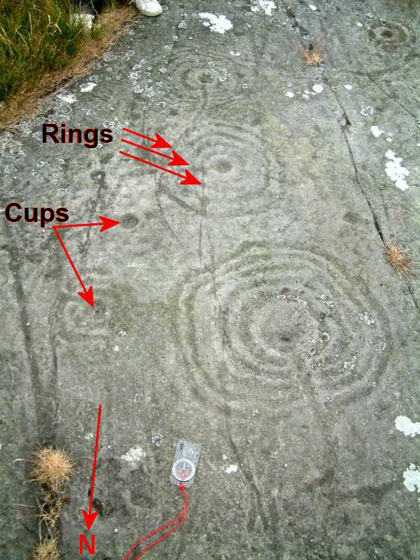
English: Typical cup-and-rings marks. These are located in Northumberland.
|
||||
| Date | |||||
| Source | Photo created by Ian Tresman on 25 July 2005. | ||||
| Author | Ian Tresman |
This file is licensed under the Creative Commons Attribution 2.5 Generic license.
- You are free:
- to share – to copy, distribute and transmit the work
- to remix – to adapt the work
- Under the following conditions:
- attribution – You must give appropriate credit, provide a link to the license, and indicate if changes were made. You may do so in any reasonable manner, but not in any way that suggests the licensor endorses you or your use.
File history
Click on a date/time to view the file as it appeared at that time.
| Date/Time | Thumbnail | Dimensions | User | Comment | |
|---|---|---|---|---|---|
| current | 14:50, 29 June 2022 | | 600 × 800 (125 KB) | Belbury (talk | contribs) | black text for legibility |
| 20:32, 21 August 2005 |  | 600 × 800 (86 KB) | Iantresman (talk | contribs) | Typical cup-and-rings marks. These are located in Northumberland, at 55.54754N 1.99632W [http://maps.google.co.uk/maps?q=55.54754N+1.99632W&spn=0.020343,0.028783&hl=en Google Maps]. {{cc-by-2.5}} Photo created by Ian Tresman on 25 July 2005. |
You cannot overwrite this file.
File usage on Commons
The following page uses this file:
- File:Annotated.jpg (file redirect)
File usage on other wikis
The following other wikis use this file:
- Usage on de.wikipedia.org
- Usage on en.wikipedia.org