File:Cup-marked boulder - geograph.org.uk - 1210994.jpg
Cup-marked_boulder_-_geograph.org.uk_-_1210994.jpg (640 × 480 pixels, file size: 142 KB, MIME type: image/jpeg)
Captions
Captions
Summary
[edit]
| Description |
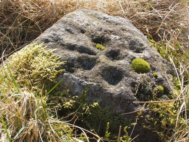
English: Cup-marked boulder. This boulder is described in the Canmore database: http://canmore.rcahms.gov.uk/en/site/43260/details/round+wood/
The pattern described there, of five cups surrounding a sixth, is still clearly visible; the photo shows the boulder backlit by the sun, making the marks more evident. Of the five cups surrounding the centre, one is wholly plugged with moss, and another is less so, but the pattern is still clear. For the context of the stone, see 1734453. Canmore also mentions a nearby boulder that bears a single cup mark; I looked for that stone, but did not find it; it has probably been overgrown during the more than thirty years since the Canmore report. This hilltop area (see 1213685) is still enclosed by the iron fence mentioned in the database. The smaller enclosure within it, outlined by boulders, is not immediately evident either on the ground or in satellite images, and it requires some patience to locate a sufficient number of boulders to discern its outline; many of the rocks can only be felt underfoot, through the vegetation. The cup-marked stone in this photograph lies near the southern end of the enclosure, and, with some care, the boundary can be followed from that point. |
| Date | |
| Source | From geograph.org.uk |
| Author | Lairich Rig |
| Camera location | | View this and other nearby images on: OpenStreetMap |
|---|
_heading:202.00&language=en)
| Object location | | View this and other nearby images on: OpenStreetMap |
|---|
_heading:202.00&language=en)
Licensing
[edit]

|
This image was taken from the Geograph project collection. See this photograph's page on the Geograph website for the photographer's contact details. The copyright on this image is owned by Lairich Rig and is licensed for reuse under the Creative Commons Attribution-ShareAlike 2.0 license.
|
- You are free:
- to share – to copy, distribute and transmit the work
- to remix – to adapt the work
- Under the following conditions:
- attribution – You must give appropriate credit, provide a link to the license, and indicate if changes were made. You may do so in any reasonable manner, but not in any way that suggests the licensor endorses you or your use.
- share alike – If you remix, transform, or build upon the material, you must distribute your contributions under the same or compatible license as the original.
File history
Click on a date/time to view the file as it appeared at that time.
| Date/Time | Thumbnail | Dimensions | User | Comment | |
|---|---|---|---|---|---|
| current | 06:21, 26 February 2011 | | 640 × 480 (142 KB) | GeographBot (talk | contribs) | == {{int:filedesc}} == {{Information |description={{en|1=Cup-marked boulder This boulder is described in the Canmore database: http://canmore.rcahms.gov.uk/en/site/43260/details/round+wood/ The pattern described there, of five cups surrounding a sixth, |
You cannot overwrite this file.
File usage on Commons
There are no pages that use this file.