File:Cuneiforme sites.svg
Jump to navigation
Jump to search

Size of this PNG preview of this SVG file: 800 × 434 pixels. Other resolutions: 320 × 174 pixels | 640 × 347 pixels | 1,024 × 555 pixels | 1,280 × 694 pixels | 2,560 × 1,388 pixels | 2,298 × 1,246 pixels.
Original file (SVG file, nominally 2,298 × 1,246 pixels, file size: 4.43 MB)
Captions
Captions
Add a one-line explanation of what this file represents
Summary
[edit]
| Description |
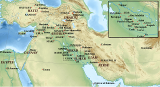
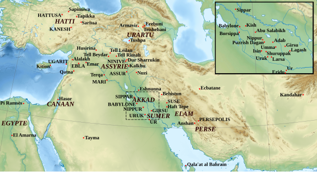
English: Location map of the archaeological sites which provided the majority of known cuneiform tablets (especially those in capitals), and some of the peripheral sites where cuneiform texts have been found in order to show the extension of the use of the cuneiform script. Français : Carte localisant les sites archéologiques qui ont livré le plus de tablettes cunéiformes (en particulier ceux en capitales) et quelques uns des sites périphériques où des textes cunéiformes ont été trouvés, illustrant l'extension de l'utilisation du cunéiforme. |
| Date | (UTC) |
| Source | |
| Author |
|
| This is a retouched picture, which means that it has been digitally altered from its original version. Modifications: Ajout des régions et villes.. The original can be viewed here: Middle East topographic map-blank.svg:
|
Licensing
[edit]
I, the copyright holder of this work, hereby publish it under the following licenses:
This file is licensed under the Creative Commons Attribution-Share Alike 3.0 Unported, 2.5 Generic, 2.0 Generic and 1.0 Generic license.
- You are free:
- to share – to copy, distribute and transmit the work
- to remix – to adapt the work
- Under the following conditions:
- attribution – You must give appropriate credit, provide a link to the license, and indicate if changes were made. You may do so in any reasonable manner, but not in any way that suggests the licensor endorses you or your use.
- share alike – If you remix, transform, or build upon the material, you must distribute your contributions under the same or compatible license as the original.

|
Permission is granted to copy, distribute and/or modify this document under the terms of the GNU Free Documentation License, Version 1.2 or any later version published by the Free Software Foundation; with no Invariant Sections, no Front-Cover Texts, and no Back-Cover Texts. A copy of the license is included in the section entitled GNU Free Documentation License. |
You may select the license of your choice.
Original upload log
[edit]
This image is a derivative work of the following images:
- File:Middle_East_topographic_map-blank.svg licensed with Cc-by-sa-3.0,2.5,2.0,1.0, GFDL
- 2010-11-03T17:52:56Z Sémhur 3097x1938 (10510751 Bytes) == {{int:filedesc}} == {{Information |Description={{Multilingual description |en= Blank physical map of the [[:en:Middle East|Middle East]] |fr= Carte physique vierge du [[:fr:Moyen-Orient|Moyen-Orient]]. }} |Source={{own}}.
Uploaded with derivativeFX
File history
Click on a date/time to view the file as it appeared at that time.
| Date/Time | Thumbnail | Dimensions | User | Comment | |
|---|---|---|---|---|---|
| current | 18:13, 17 December 2011 | | 2,298 × 1,246 (4.43 MB) | Zunkir (talk | contribs) | == {{int:filedesc}} == {{Information |Description={{Multilingual description |en= Location map of the archaeological sites which provided the majority of known cuneiform tablets (especially those in capitals), and some of the peripheral sites where cuneif |
You cannot overwrite this file.
File usage on Commons
The following page uses this file:
File usage on other wikis
The following other wikis use this file:
- Usage on ca.wikipedia.org
- Usage on fr.wikipedia.org
- Usage on he.wikipedia.org
- Usage on pl.wikipedia.org