File:Culverted beck alongside Castle Carrock Reservoir - geograph.org.uk - 1433223.jpg
Jump to navigation
Jump to search
No higher resolution available.
Culverted_beck_alongside_Castle_Carrock_Reservoir_-_geograph.org.uk_-_1433223.jpg (640 × 480 pixels, file size: 421 KB, MIME type: image/jpeg)
Captions
Captions
Add a one-line explanation of what this file represents
Summary
[edit]
| Description |
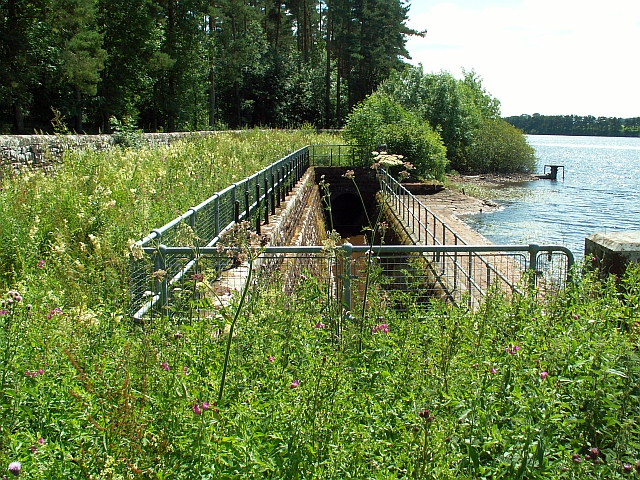
English: Culverted beck alongside Castle Carrock Reservoir. Castle Carrock is a storage reservoir - the water is piped by gravity from streams and springs in Geltsdale, 3 or 4km away (see 461858 ) . The source was chosen for its purity, but from a geological point of view the most suitable place to build a reservoir was in the valley of the Castle Carrock Beck. The beck that was originally here flowed through agricultural land, so not good for drinking water. The solution was to divert it through an underground culvert around the edge of the reservoir. This photo shows a small section which is uncovered, before the culvert goes underneath the dam. The beck comes out beside the water works *LINK photo* , then continues as normal round the edge of Castle Carrock village. (Information from guided tour, also from booklet "Castle Carrock Reservoir Centenary, 1909-2009" by Tom Speight - see http://downloads.bbc.co.uk/cumbria/castle_carrock_reservoir.pdf ). |
| Date | |
| Source | From geograph.org.uk |
| Author | Rose and Trev Clough |
| Attribution (required by the license) | Rose and Trev Clough / Culverted beck alongside Castle Carrock Reservoir / |
| Camera location | | View this and other nearby images on: OpenStreetMap |
|---|
_heading:202.00&language=en)
| Object location | | View this and other nearby images on: OpenStreetMap |
|---|
_heading:202.00&language=en)
Licensing
[edit]

|
This image was taken from the Geograph project collection. See this photograph's page on the Geograph website for the photographer's contact details. The copyright on this image is owned by Rose and Trev Clough and is licensed for reuse under the Creative Commons Attribution-ShareAlike 2.0 license.
|
This file is licensed under the Creative Commons Attribution-Share Alike 2.0 Generic license.
Attribution: Rose and Trev Clough
- You are free:
- to share – to copy, distribute and transmit the work
- to remix – to adapt the work
- Under the following conditions:
- attribution – You must give appropriate credit, provide a link to the license, and indicate if changes were made. You may do so in any reasonable manner, but not in any way that suggests the licensor endorses you or your use.
- share alike – If you remix, transform, or build upon the material, you must distribute your contributions under the same or compatible license as the original.
File history
Click on a date/time to view the file as it appeared at that time.
| Date/Time | Thumbnail | Dimensions | User | Comment | |
|---|---|---|---|---|---|
| current | 22:26, 1 March 2011 | | 640 × 480 (421 KB) | GeographBot (talk | contribs) | == {{int:filedesc}} == {{Information |description={{en|1=Culverted beck alongside Castle Carrock Reservoir Castle Carrock is a storage reservoir - the water is piped by gravity from streams and springs in Geltsdale, 3 or 4km away (see 461858 ) . The s |
You cannot overwrite this file.
File usage on Commons
There are no pages that use this file.