File:Cuenca-111-B.svg

Original file (SVG file, nominally 2,206 × 1,365 pixels, file size: 10.26 MB)
Captions
Captions
Summary
[edit]
| Description |
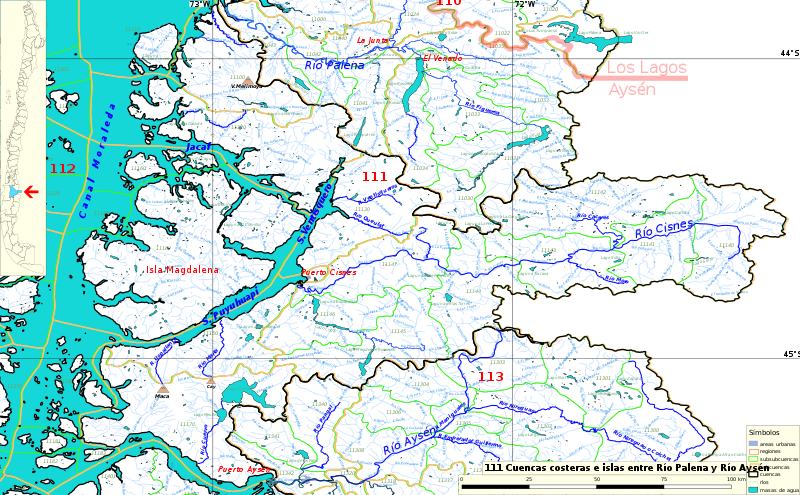
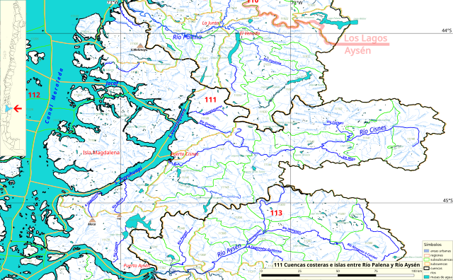
Español: Cuenca 11 (río Cisnes, río Picacho) del inventario de cuencas de Chile.
Este mapa se elaboró con información extraída de:
Donde BNC, MMA y cedeus significan:
Los datos fueron procesados con QGIS version 2.18.17, exportados al formato SVG con las opciones "render map labels as outlines" desconectada pero "export map layers as svg groups" conectada. Con Inkscape 0.92 se eliminó la excesiva repetición de nombres, los nombres fueron colocados paralelos a los ríos o lagos y en lugares más visibles. Nombres y números que el editor no pudo asociar a objeto alguno fueron borrados. Finalmente se redujo el volumen de datos por medio de svgo (svg-optimizer). |
| Date | |
| Source | Own work |
| Author | Juan Villalobos |
Licensing
[edit]
- You are free:
- to share – to copy, distribute and transmit the work
- to remix – to adapt the work
- Under the following conditions:
- attribution – You must give appropriate credit, provide a link to the license, and indicate if changes were made. You may do so in any reasonable manner, but not in any way that suggests the licensor endorses you or your use.
- share alike – If you remix, transform, or build upon the material, you must distribute your contributions under the same or compatible license as the original.
File history
Click on a date/time to view the file as it appeared at that time.
| Date/Time | Thumbnail | Dimensions | User | Comment | |
|---|---|---|---|---|---|
| current | 12:00, 19 December 2022 | | 2,206 × 1,365 (10.26 MB) | Juan Villalobos (talk | contribs) | More names |
| 09:10, 26 June 2019 |  | 2,206 × 1,365 (7.29 MB) | Juan Villalobos (talk | contribs) | svgcleaner, mar azul, divisiones adm., marco negro para simbolos. | |
| 21:23, 15 February 2019 |  | 2,353 × 1,456 (4.67 MB) | Juan Villalobos (talk | contribs) | User created page with UploadWizard |
You cannot overwrite this file.
File usage on Commons
The following 2 pages use this file:
File usage on other wikis
The following other wikis use this file:
- Usage on arz.wikipedia.org
- Usage on es.wikipedia.org
- Río Cisnes
- Termas de Puyuhuapi
- Canal Puyuhuapi
- Categoría:Cuencas costeras e islas entre Río Palena y Río Aysén (111)
- Río Queulat
- Río Cáceres
- Cuenca del río Cisnes
- Río Uspallante
- Río Cuervo (Fiordo Aysén)
- Lago Meullín
- Lago Yulton
- Río Grande (Cisnes)
- Río Moro
- Río Picacho
- Lago Presidente Roosevelt
- Lago Copa
- Laguna Escondida (Picacho)
- Lago Las Torres
- Río Ventisquero (al sur del fiordo Ventisquero)
- Río Macá
- Cuencas costeras e islas entre río Palena y río Aysén
- Río Magdalena (Cáceres)
- Usage on www.wikidata.org