File:Cuenca-060-B.svg

Original file (SVG file, nominally 1,301 × 841 pixels, file size: 8.04 MB)
Captions
Captions
Summary
[edit]
| Description |
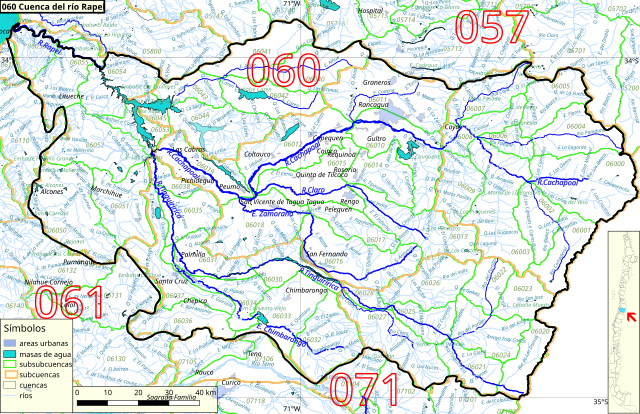
Español: Cuenca 060, del río Rapel, del inventario nacional de cuencas de Chile
Este mapa se elaboró con información extraída de:
Donde BNC, MMA y cedeus significan:
Los datos fueron procesados con QGIS version 2.18.17, exportados al formato SVG con las opciones "render map labels as outlines" desconectada pero "export map layers as svg groups" conectada. Con Inkscape 0.92 se eliminó la excesiva repetición de nombres, los nombres fueron colocados paralelos a los ríos o lagos y en lugares más visibles. Nombres y números que el editor no pudo asociar a objeto alguno fueron borrados. Finalmente se redujo el volumen de datos por medio de svgo (svg-optimizer). |
| Date | |
| Source | Own work |
| Author | Juan Villalobos |
Licensing
[edit]
- You are free:
- to share – to copy, distribute and transmit the work
- to remix – to adapt the work
- Under the following conditions:
- attribution – You must give appropriate credit, provide a link to the license, and indicate if changes were made. You may do so in any reasonable manner, but not in any way that suggests the licensor endorses you or your use.
- share alike – If you remix, transform, or build upon the material, you must distribute your contributions under the same or compatible license as the original.
File history
Click on a date/time to view the file as it appeared at that time.
| Date/Time | Thumbnail | Dimensions | User | Comment | |
|---|---|---|---|---|---|
| current | 15:43, 26 August 2019 | | 1,301 × 841 (8.04 MB) | Juan Villalobos (talk | contribs) | agrego "Río Cachapoal" en la cordillera. |
| 18:57, 18 June 2019 |  | 1,301 × 841 (4.71 MB) | Juan Villalobos (talk | contribs) | svgcleaner, rios importantes con letras mas grandes. | |
| 14:12, 27 May 2019 |  | 1,301 × 841 (4.77 MB) | Juan Villalobos (talk | contribs) | svgcleaner, lat+long, Quebrada-->Q. etc. | |
| 18:35, 6 February 2019 |  | 1,388 × 896 (3.7 MB) | Juan Villalobos (talk | contribs) | limpieza | |
| 08:58, 1 February 2019 |  | 1,388 × 896 (3.75 MB) | Juan Villalobos (talk | contribs) | User created page with UploadWizard |
You cannot overwrite this file.
File usage on Commons
The following page uses this file:
File usage on other wikis
The following other wikis use this file:
- Usage on es.wikipedia.org
- Río Cachapoal
- Lago Rapel
- Río Rapel
- Río Tinguiririca
- Central hidroeléctrica Rapel
- Termas del Flaco
- Laguna El Encanto
- Laguna de Tagua Tagua
- Embalse Convento Viejo
- Laguna de los Cristales
- Río Claro de Rengo
- Embalse Carén
- Categoría:Cuenca del río Rapel (060)
- Río Claro (Tinguiririca)
- Cuenca del río Rapel
- Estero Alhué
- Canal Teno-Chimbarongo
- Estero Carén (Alhué)
- Estero Chimbarongo
- Estero La Cadena (Cachapoal)
- Estero Zamorano
- Canal Zamorano
- Central hidroeléctrica Sauzal
- Central hidroeléctrica Sauzalito
- Estero La Cadena (Tinguiririca)
- Río Cortaderal
- Laguna Pejerreyes
- Laguna Matancilla
- Laguna del Yeso
- Río Azufre (Tinguiririca)
- Laguna Cauquenes
- Embalse Barahona I
- Canal de relaves Colón-Carén
- Río Las Leñas
- Río Damas (Tinguiririca)
- Río Palacios
- Río San José (Azufre)
- Río Portillo (San José)
- Arroyo de los Humos
- Río Seco (Cachapoal)
- Usage on sh.wikipedia.org
- Usage on www.wikidata.org