File:Cuenca-052-053-054-B.svg

Original file (SVG file, nominally 1,300 × 844 pixels, file size: 5.14 MB)
Captions
Captions
Summary
[edit]
| Description |
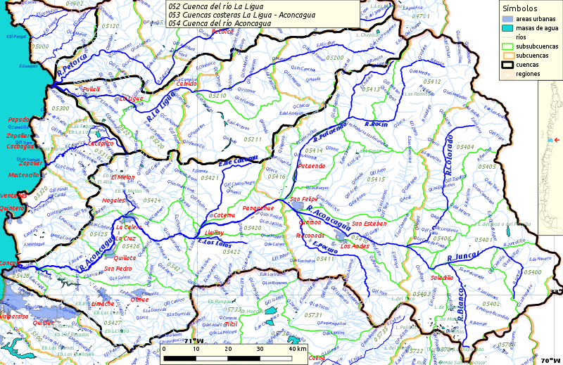
Español: Cuencas hidrográficas 052, 053 y 054 del inventario nacional de cuencas de Chile
Este mapa se elaboró con información extraída de:
Donde BNC, MMA y cedeus significan:
Los datos fueron procesados con QGIS version 2.18.17, exportados al formato SVG con las opciones "render map labels as outlines" desconectada pero "export map layers as svg groups" conectada. Con Inkscape 0.92 se eliminó la excesiva repetición de nombres, los nombres fueron colocados paralelos a los ríos o lagos y en lugares más visibles. Nombres y números que el editor no pudo asociar a objeto alguno fueron borrados. Finalmente se redujo el volumen de datos por medio de svgo (svg-optimizer). |
| Date | |
| Source | Own work |
| Author | Juan Villalobos |
Licensing
[edit]
- You are free:
- to share – to copy, distribute and transmit the work
- to remix – to adapt the work
- Under the following conditions:
- attribution – You must give appropriate credit, provide a link to the license, and indicate if changes were made. You may do so in any reasonable manner, but not in any way that suggests the licensor endorses you or your use.
- share alike – If you remix, transform, or build upon the material, you must distribute your contributions under the same or compatible license as the original.
File history
Click on a date/time to view the file as it appeared at that time.
| Date/Time | Thumbnail | Dimensions | User | Comment | |
|---|---|---|---|---|---|
| current | 10:27, 15 July 2019 | | 1,300 × 844 (5.14 MB) | Juan Villalobos (talk | contribs) | Creada con versión 3.4 de QGIS. Sin aplicación de svgo, svgclener u otro compresor. Mar, layers, etc. |
| 20:47, 14 July 2019 |  | 1,387 × 900 (3.18 MB) | Juan Villalobos (talk | contribs) | Reverted to version as of 08:45, 1 February 2019 (UTC) | |
| 20:45, 14 July 2019 |  | 1,300 × 844 (5.98 MB) | Juan Villalobos (talk | contribs) | Creada con versión 3.4 de QGIS. Sin aplicación de svgo, svgclener u otro compresor. Mar, layers, etc. | |
| 08:45, 1 February 2019 |  | 1,387 × 900 (3.18 MB) | Juan Villalobos (talk | contribs) | User created page with UploadWizard |
You cannot overwrite this file.
File usage on Commons
The following 2 pages use this file:
File usage on other wikis
The following other wikis use this file:
- Usage on es.wikipedia.org
- Río Aconcagua
- Río Juncal
- Río Putaendo
- Laguna del Inca
- Termas de Jahuel
- Estero Limache
- Embalse Los Aromos
- Embalse Chacrillas
- Río Colorado (Aconcagua)
- Río Leones (Blanco)
- Categoría:Cuenca del río Aconcagua (054)
- Río Blanco (Aconcagua)
- Cuenca del río Aconcagua
- Embalse Lliu-Lliu
- Central hidroeléctrica Hornitos
- Central hidroeléctrica Los Quilos
- Estero Pocuro
- Estero Los Loros
- Estero Catemu
- Estero Quilpué (Aconcagua)
- Estero Los Litres
- Río Rocín
- Río Juncalillo
- Canal Waddington
- Parque andino Juncal
- Quebrada Los Maquis
- Río Hidalgo
- Baños de Auco
- Río Tambillos (Rocín)
- Río Blanco (Colorado)
- Río Riecillos
- Río Leones (Riecillos)
- Estero El Cobre
- Tranque de relaves El Cobre
- Baños de Higuera
- Baños del Alto
- Baños de Lobo
- Usage on fr.wikipedia.org
- Usage on pl.wikipedia.org
- Usage on www.wikidata.org