File:Crumlin - geograph-2997256-by-Albert-Bridge.jpg
Jump to navigation
Jump to search
No higher resolution available.
Crumlin_-_geograph-2997256-by-Albert-Bridge.jpg (547 × 514 pixels, file size: 102 KB, MIME type: image/jpeg)
Captions
Captions
Add a one-line explanation of what this file represents
Summary
[edit]
| Description |
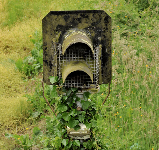
English: Signal, Crumlin station A disused and ivy-covered signal, at the Lisburn/Belfast end of the loop J1576 : Railway, Crumlin (2) on the “mothballed” line, at Crumlin J1576 : Railway, Crumlin (1). When needed the line is worked as one section. When open it had three sections: Lisburn – Ballinderry, Ballinderry – Crumlin and Crumlin – Antrim. For comparison see J1576 : Crumlin station - August 2014(2) after remedial work to retain the line in a safe running order. |
| Date | |
| Source | From geograph.org.uk |
| Author | Albert Bridge |
| Permission (Reusing this file) |
Creative Commons Attribution Share-alike license 2.0 |
| Attribution (required by the license) | Albert Bridge / Signal, Crumlin station / |
| Camera location | | View this and other nearby images on: OpenStreetMap |
|---|
_region:GB-NIR_heading:202.00&language=en)
| Object location | | View this and other nearby images on: OpenStreetMap |
|---|
_region:GB-NIR_heading:202.00&language=en)
Licensing
[edit]

|
This image was taken from the Geograph project collection. See this photograph's page on the Geograph website for the photographer's contact details. The copyright on this image is owned by Albert Bridge and is licensed for reuse under the Creative Commons Attribution-ShareAlike 2.0 license.
|
This file is licensed under the Creative Commons Attribution-Share Alike 2.0 Generic license.
Attribution: Albert Bridge
- You are free:
- to share – to copy, distribute and transmit the work
- to remix – to adapt the work
- Under the following conditions:
- attribution – You must give appropriate credit, provide a link to the license, and indicate if changes were made. You may do so in any reasonable manner, but not in any way that suggests the licensor endorses you or your use.
- share alike – If you remix, transform, or build upon the material, you must distribute your contributions under the same or compatible license as the original.
File history
Click on a date/time to view the file as it appeared at that time.
| Date/Time | Thumbnail | Dimensions | User | Comment | |
|---|---|---|---|---|---|
| current | 13:36, 2 December 2020 | | 547 × 514 (102 KB) | Lamberhurst (talk | contribs) | == {{int:filedesc}} == {{Information |Description={{en|1=<b>Signal, Crumlin station</b><br>A disused and ivy-covered signal, at the Lisburn/Belfast end of the loop J1576 : Railway, Crumlin (2) on the “mothballed” line, at Crumlin J1576 : Railway, Crumlin (1). When needed the line is worked as one section. When open it had three sections: Lisburn – Ballinderry, Ballinderry – Crum... |
You cannot overwrite this file.
File usage on Commons
The following 2 pages use this file: