File:Croick Old Parish Church - geograph.org.uk - 68634.jpg
Jump to navigation
Jump to search
No higher resolution available.
Croick_Old_Parish_Church_-_geograph.org.uk_-_68634.jpg (640 × 468 pixels, file size: 175 KB, MIME type: image/jpeg)
Captions
Captions
Add a one-line explanation of what this file represents
|
This is a photo of listed building number 7181. |
Summary
[edit]
| Description |
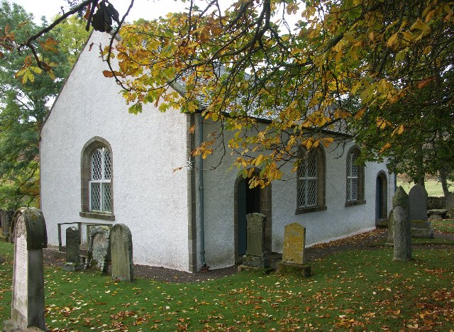
English: Croick Old Parish Church. Croick Church was built, with Government Grants, in 1827 at a cost of £1527 to plans by Thomas Telford.
Glencalvie was cleared in 1845 and the names of many of the people evicted can be seen scratched in the windows of the church. |
| Date | |
| Source | From geograph.org.uk |
| Author | J M Briscoe |
| Attribution (required by the license) | J M Briscoe / Croick Old Parish Church / |
| Camera location | | View this and other nearby images on: OpenStreetMap |
|---|
_&language=en)
| Object location | | View this and other nearby images on: OpenStreetMap |
|---|
_&language=en)
Licensing
[edit]

|
This image was taken from the Geograph project collection. See this photograph's page on the Geograph website for the photographer's contact details. The copyright on this image is owned by J M Briscoe and is licensed for reuse under the Creative Commons Attribution-ShareAlike 2.0 license.
|
This file is licensed under the Creative Commons Attribution-Share Alike 2.0 Generic license.
Attribution: J M Briscoe
- You are free:
- to share – to copy, distribute and transmit the work
- to remix – to adapt the work
- Under the following conditions:
- attribution – You must give appropriate credit, provide a link to the license, and indicate if changes were made. You may do so in any reasonable manner, but not in any way that suggests the licensor endorses you or your use.
- share alike – If you remix, transform, or build upon the material, you must distribute your contributions under the same or compatible license as the original.
File history
Click on a date/time to view the file as it appeared at that time.
| Date/Time | Thumbnail | Dimensions | User | Comment | |
|---|---|---|---|---|---|
| current | 14:23, 30 January 2010 | | 640 × 468 (175 KB) | GeographBot (talk | contribs) | == {{int:filedesc}} == {{Information |description={{en|1=Croick Old Parish Church. Croick Church was built, with Government Grants, in 1827 at a cost of £1527 to plans by Thomas Telford. Glencalvie was cleared in 1845 and the names of many of the people |
You cannot overwrite this file.
File usage on Commons
The following page uses this file:
File usage on other wikis
The following other wikis use this file:
- Usage on de.wikipedia.org
- Usage on en.wikipedia.org
- Usage on www.wikidata.org