File:Croatian homerule.png
Jump to navigation
Jump to search

Size of this preview: 619 × 599 pixels. Other resolutions: 248 × 240 pixels | 496 × 480 pixels | 793 × 768 pixels | 1,057 × 1,024 pixels | 1,809 × 1,752 pixels.
Original file (1,809 × 1,752 pixels, file size: 157 KB, MIME type: image/png)
Captions
Captions
Add a one-line explanation of what this file represents
Summary[edit]
| Description |
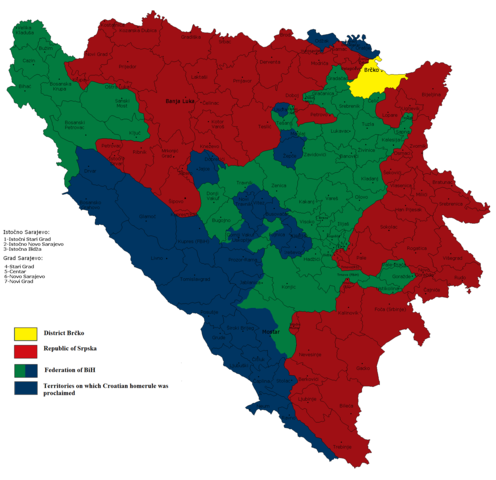
English: Territiories on which Croatian homerule was proclaimed
Hrvatski: Teritorij na kojemu je proglašena hrvatska samouprava |
| Date | 12.06.2009. |
| Source | Own work |
| Author | Ceha |
Licensing[edit]
| I, the copyright holder of this work, release this work into the public domain. This applies worldwide. In some countries this may not be legally possible; if so: I grant anyone the right to use this work for any purpose, without any conditions, unless such conditions are required by law. |
File history
Click on a date/time to view the file as it appeared at that time.
| Date/Time | Thumbnail | Dimensions | User | Comment | |
|---|---|---|---|---|---|
| current | 12:50, 10 February 2022 | | 1,809 × 1,752 (157 KB) | Ceha (talk | contribs) | Uskoplje Fojnica |
| 22:41, 1 February 2022 |  | 1,809 × 1,752 (157 KB) | Ceha (talk | contribs) | Dusina i Ždrimci | |
| 14:40, 23 January 2022 |  | 1,809 × 1,752 (157 KB) | Ceha (talk | contribs) | Uzmjene oko Mostara, Fojnice i Maglaja | |
| 22:01, 21 June 2015 |  | 1,809 × 1,752 (220 KB) | Ceha (talk | contribs) | Slight changes on the north of Mostar | |
| 21:58, 21 June 2015 |  | 1,809 × 1,752 (220 KB) | Ceha (talk | contribs) | Slight changes around Uskoplje and Fojnica | |
| 09:06, 2 December 2014 |  | 1,809 × 1,752 (156 KB) | Ceha (talk | contribs) | rv (colors) | |
| 11:10, 8 October 2014 |  | 1,809 × 1,752 (155 KB) | Gryffindor (talk | contribs) | {{Information |Description= |Source={{own}} |Date= |Author= Gryffindor |Permission= |other_versions= }} | |
| 19:30, 16 October 2013 |  | 1,809 × 1,752 (156 KB) | Ceha (talk | contribs) | Preciznija linija u Fojnici, Uskoplju i Novom Šeeru | |
| 10:09, 13 June 2009 |  | 1,809 × 1,752 (195 KB) | Ceha (talk | contribs) | Excluded parts which were not part of Croatian homerule... | |
| 19:10, 12 June 2009 |  | 1,809 × 1,752 (193 KB) | Ceha (talk | contribs) | {{Information |Description={{en|1=Territiories on which Croatian homerule was proclaimed}} {{hr|1=Teritorij na kojemu je proglašena hrvatska samouprava}} |Source=Vlastito djelo postavljača |Author=Ceha |Date=12.06.2009. |Permission= |other |
You cannot overwrite this file.
File usage on Commons
The following page uses this file:
File usage on other wikis
The following other wikis use this file:
- Usage on en.wikipedia.org
- Usage on fr.wikipedia.org
- Usage on hr.wikipedia.org
- Usage on sr.wikipedia.org
- Usage on uk.wikipedia.org